
-
 5326 Hits
-
 74.01% Score
-
 4 Votes
|
|
Route |
|---|---|
|
|
35.31793°N / 24.00255°E |
|
|
Hiking |
|
|
Spring, Summer, Fall, Winter |
|
|
Half a day |
|
|
Hike |
|
|
Overview
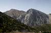
 Volakias and Gingilos with the Kallergi Hut up front Volakias and Gingilos with the Kallergi Hut up front |
The character of the normal route to Melindaou is a long hike - never difficult in any section, never exposed, but long and strenuous. From the trailhead at Xyloskalo the route takes roughly4h, 2h of which are needed for the approach to the starting point of the climb.
The climb itself is a long - sometimes steep -mountain path which heads for the south of the Melindaou summit. The only slightly tricky section is near the top where orientation gets difficult. The path to the summit is unmarked and - there is more than one way to the top. Since the summit plateau is broad and in no way difficult to reach orientation on the karst plateau is the only issue.
|


Getting There
 The Omalos Plain as seen from the trailhead at Xyloskalo
The trailhead is at Xyloscalo, the entrance point to the Samaria Gorge. See the main page for the information of how to reach it.
At Xyloscalo, at the eastern side of the parking lot, there is the starting point for a narrow mountain trail, which traverses a steep slope. It leads to the Kallergi Hut and cuts short the road ascent (which would descend in direction of Omalos, then ascend to the hut). It basically keeps the same height and joins the road to the hut further on eastwards. The road the ascends in long switchbacks to the hut.
Even if you don't plan to stay at the hut - take the extra efort to visit it. It is perched on a rock high above the Samaria Gorge, the only place where you actually can look down into the eyries of golden eagles. From the hut a path cuts short a long switchback in the road.This path heads down along the ridge towards the Samaria Gorge and again offers great views into the canyon below. You regain the road 200m beneath the hut and follow it for approximately 3 km. In another switchback you reach the Shepherd's Saddle, where another hut, this time a shepherds' one is perched above he abyss. While the Psrai / Mavri Ridge route turns off here to the right we follow the road for another 1km.
Route Description
 Northward view from the vicinity of Shepherds' Saddle
- Start altitude: 1300m
- Summit altitude: 2133m
- Prevailing exposure: N
- Type: 4h one way
- Protection: None
After the Shepherds's saddle we follow the route for another km passing an intersection to the summer village of Bouia. about 400m behind the intersection an E4-pole marks the way to Melindaou. Leave the road to the right and climb steeply across the talus until you gain the bed of a dried out creek. This bed will take you up to a beautiful high plateau - the typical type of the Levka Ori Range - flat, circular and surrounded by hills.
Hike to the far end of the plateau where a steep switch-backing route takes you up towards (still invisible) Melindaou. As you head out of the surrounding hills you get a first glimpse of the Melindaou north face, a steep scree slope, topped by a plateau. Instead of going directly for the summit, rather head for a saddle to the west of it, which you cross and - following E4 further on - you reach the summit south slopes. E4 turns off to the right but rather follow a narow path for the remaining 100m to the broad summit plateau of the mountain.