
|
|
Route |
|---|---|
|
|
Download GPX » View Route on Map |
|
|
Hiking, Mountaineering, Scrambling |
|
|
Winter |
|
|
Expedition |
|
|
Class 3 |
|
|
Very hard |
|
|
III |
|
|
 At the extreme south part of the east border lies the distant Giant Peak of Itatiaia. Pretty hard to get to. We tried from six different spots but the woods were brave...
The East Border od Itatiaia NP bring you the oportunity to summit some challenging (very!) brazilian mountains. Mountains that are not like the west border (too much touristic). The mountains on that side, the often visited side, get summited pretty much every day. By winter, Agulhas Negras can be summited by 100 people in one single day.
At the east side, mountains rarely get visiters, so its summit register shows how few are brave enough to reach its tops. Some of them like Gorila, or Lion's Head, or Female Lion's Head get summited just once or twice a year, truth.
As you can see the timeline goes as far as Gorila Peak, but the treklog at the image shows we went further away. Yes we did. We were trying to get to Giant Peak, really difficult to fight the woods for days and days. It took us five days and four nights in and out and we didn't make it to the top. You may cross the valley as the route on the sat image, but all you can get is close to the south summit (there are 5 of them) of Leoa Peak, cross a few ridges and valleys and stop with that very same view. This is the reason the route time is set for "expedition", because if you wanna enjoy the place, you'll need at least five days and four nights, and that means food for 5 days, clothing, extra socks, snacks, bla bla bla...Too much stuff.
Getting There
Depending on your choice, you have to get to different cities outside the limit of the park.By bus
From Minais Gerais/ São Paulo/ Rio de Janeiro, you have to take a bus to a city called Resende. Several bus companies can take you there. Once you get there, take another bus to Visconde de Mauá village, a smaller town at the bottom of the Sierra.
Route Sat Image Description
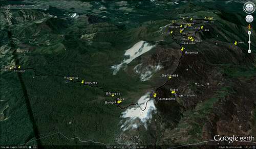 Info view of the route
The route (timeline like style)
You can start the trekking at Visconde de Mauá city, at Escorrega Waterfall (Cachoeira do Escorrega in Portuguese), there is a road at the left side of the waterfall, half an hour walking up you’ll get to a small farm. Ask nicely to the owner to cross his property and show you the trailhead. It is easy and well marked, impossible to get lost. The altitude gain to get to the base of Maromba Peak is around 1.200 meters. It's good to establish a base camp after so many walking and do the summit next morning. You’ll be camped at around 2.280 meters and that means you'll be camped at only a couple hundred meters lower than the summit itself, but don't think that will be easy, you will have to fight the woods, sometimes higher than you. Water nearby (60 or 70 meters away, that’s it).The image pretty much explains everything by itself. You'll be hiking up all the time towards Marombinha Peak, which is the north summit of Maromba Peak, highest summit of the whole east border. Marombinha is just where a huge cloud damaged the sat photo.
 First bivy spot at 1.950m high. This is next morning, gear up, on your feet, start hiking up!
 The approach will pretty much force you to take dozens of photos...
 Well, from this part the way is quite obvious, hike up the ridge all the way to Maromba Peak summit. The photo below shows the summit of Maromba in Splattski style
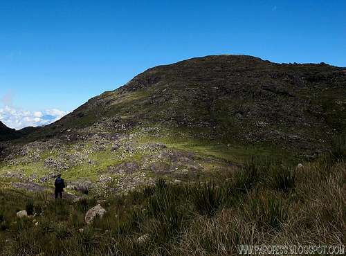 Everything changes from now on. You'll be at a real salvage part of the part, start the oposite descent from Maromba Peak summit, going by the southwest ridge. Going down the opposite ridge
 This is what you see at the bottom of the opposite ridge of Maromba Peak, folow the river until you find this. Down there you can find yourself several places to set your bivy. Note: There is no good places for tents here or anywhere else at the east border. In order to use a tent, you'll have to remove vegetation for 10 or 20 minutes.
 Time to get some sleep, you will need for next day!
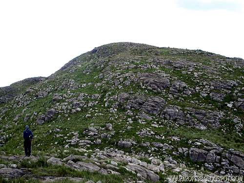 For starters, hike up Leoa Peak, easy from where you are.
 Looking west, this is the view you'll get.
 And when you least expect, Bam! You're at the summit looking west. Notice by Tacio Lion's Head Peak (with two summits). You can go on a straight line towards its summit. A couple hours from where you are now.
 Informative view, west view.Time to get some sleep one more time, you will need again for next day!
 Full belly, get up early and summit Gorila Peak, short hike up from the bivy spot
 Photos, photos...No need to save the camera, click on. The second summit of Gorila has amazing rocky walls...
 Once you get down, feel free to explore the area and find beauties like this one. A brazilian alpine flower of just 2cms.Time to get some sleep once more, next day you have to get back! After all, you just summited some of the most isolated brazilian mountains.
[img:789237:alignleft:medium:Time to get some sleep once more, next day you have to get back! After all, you just summited some of the most isolated brazilian mountains.]
Essential Gear
>Good hiking shoes>Down jacket
>Wind proof jacket/ water proof jacket
>Trekking poles (optional)
>Gloves
>2l of water (there is a creek cross on half the way but not always there is enough to colect)
>Sunglasses
>Suncream
>Snack
>Extra pair of socks
>Food for at least 5 days
Red Tape
If you go by the high entrance of the park, as soon as you get there register yourself and pay a fee of R$ 12,00 (about USD 7.00) for the entrance.Parking lot at the entrance;
Well marked trails (just to camp by Marombinha Peak and Maromba summit);
What’s forbidden:
At all costs, don't make fire or Deforest any places. Respect the nature and wildlife please!
BE CAREFUL ABOUT SNAKES AND POISONOUS SPIDERS (BROWN SPIDER)
A GPS is highly recommended for that part of the park, on a foggy day you will be lost in no time.
Weather Forecast
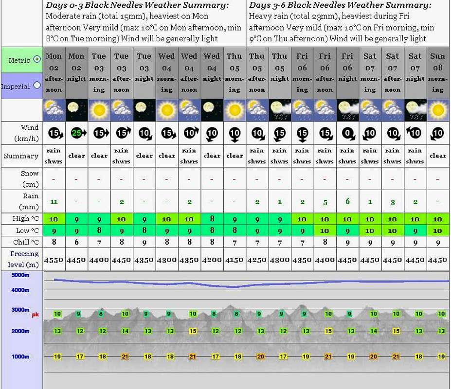
PS: The weather forecast on this link is not for this mountain but it will do just fine since the mountain from the forcast (Black Needles) is just a few kms away from it.
Legal Issues
To hike/ climb is a dangerous activity and requires proper equipment and clothing, the owner of this page cannot be blamed by injuries caused to anyone who read this page for its info about the mountain, and eventually got hurt by doing so with reckless behaviour or bad weather conditions.
Paulo Roberto Felipe Schmidt – AKA: PAROFES
External Links
A brazilian website to get mountains info, including gps files to download:http://www.rumos.net.br/rumos/My youtube channel: www.youtube.com/parofes - Now with 250+ videos online!
The biggest brazilian website about climbing and mountaineering, for which I'm a columnist: