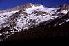
Approach
Use the eastside trailhead at Saddlebag Lake. Proceed downhill below the dam toward southwest, through a sparse forest. A use trail is sometimes visible but not consistent. When you reach the bottom of the valley follow the old dirt road going straight west toward Mount Conness, passing the Carnegie Institute storage shed. After about 2 miles get off the trail on the right and start ascending a 800 foot bench, through a grassy slope with cascades. Make sure you head straight west, and you'll reach Alpine Lake above the bench. Cross the right side of Alpine Lake through talus.
Route Description
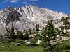
Ascend gentle slabs and talus in the basin west of Alpine Lake. The summit plateau of Mt. Conness is straight ahead, scramble up the ridge (the "East Ridge") on the right side of the basin, where you can overlook Conness Glacier. Ascend the ridge to a steep class 2-3 buttress (50-60 degrees), climb up following some use trails until you top out on the summit plateau. Mark the spot where you came up. The summit plateau is almost flat and half a mile wide. Walk towards the summit, which is connected to the plateau by a thin ridge. Follow it to the summit, passing through some exposed ledges on the left side.
Essential Gear
None if route is snow free.
GPS Track Log
A Google Earth track log of SP member
barneyzang's trip up the East Ridge from Alpine Lake route can be found
here.
Miscellaneous Info
If you have information about this route that doesn't pertain to any of the other sections, please add it here.


barneyzang - Sep 10, 2005 6:03 pm - Hasn't voted
Route CommentA Google Earth track log of my trip up the East Ridge from Alpine Lake route can be found here.
gordonye - Sep 12, 2005 1:37 pm - Hasn't voted
Route CommentWow, that is great! Thanks for posting!