
|
|
Route |
|---|---|
|
|
39.39700°N / 106.1°W |
|
|
Ski Descent |
|
|
Most of a day |
|
|
Intermediate (Backcountry) |
|
|
Approach
East Ridge Trailhead
From Highway 9, turn west onto Summit County 850, following signs to "Blue Lakes". Take an immediate right (north) onto McCullough Gulch Road (Summit County 851) and drive 1000 feet to the main trailhead. In winter and spring, closure will be right off the main road here, where a small parking area is plowed. Park here.
There has been some confusion about this trailhead recently. The "old" trailhead has been closed due to private property concerns and the CFI has built a new one. The new trail is closer to 850 than the old. Check out this helpful photo and use what is called the "main" trailhead.
Route Description
Backcountry skiers, this is one of the best!
Park your car at the snow closure, skin up, and click into your bindings. If you time it right, you should be able to go all the way to the summit without carrying your skis. You will follow the standard Quandary trail the entire way to the summit. You may vary this based on avy conditions or snowcover, but in general, you will simply follow the main trail.
The best time of year for this ski is in mid to late Spring, although it has been done often in winter in stable conditions. You can preview much of the route from CO 9. See the section below on avalanche information.
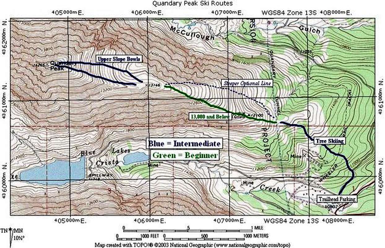
Ski Lines and Ratings Refer to TOPO! Below
For simplicity, I'll break this up into three sections:
(1) Car to Treeline Rating: Intermediate
This is quite easy going up with skins or bootpacking. On descent, this is usually very enjoyable if you are comfortable tree-skiing. If not, this forest can tend to be very tight and you might want to pack your skis out. The main trail is a little tight, but you can snowplow most of it comfortably. The angle is very low, but like I said, the trees are tight.
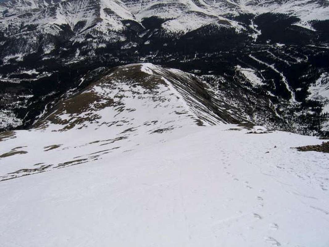
(2) Treeline to 13,000 feet Rating: Beginner
I use 13,000 feet here as a general term. At approximately this altitude, the terrain flattens out before the final steeper pitch.
In general here, stick to the main summer trail. There will be less avy danger if you stick close to the south side of the ridge. An avalanche was triggered here where the slope reaches 40 degrees, far to the north side. (See below for details.)
On the descent, just pick your line based on conditions. Most of the slope is 20 to 30 degrees, so this is definitely beginner terrain.
It might be a good idea to cache your skis above this slope and ski down from here if you are a beginner.
(3) 13,000 feet to summit Rating: Intermediate
This is the most difficult part to climb and ski. The max angle of this area is just about 38 degrees. The number 38 should get your avy senses tingling. Make sure your descent is safe. Climbing here can be very safe if you stick to the south side of the ridge and stay away from the bowls.
For the descent, pick one of two major bowls. (See photo below.) This is rated intermediate.
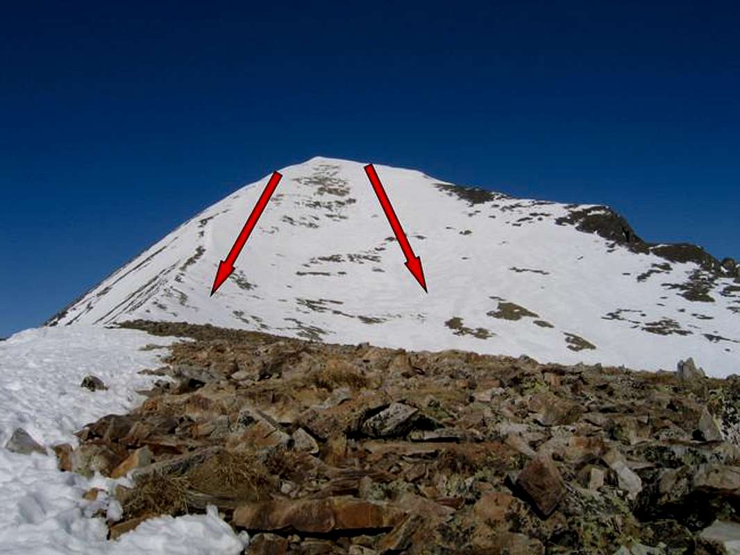
The Two Main Bowls on the Upper Quandary Slopes. Both are of similar difficulty.
This photo was taken in April 2005 from just below the summit, and shows the steepness of the upper slopes you will ski.
Does this look tougher than "intermediate?" See my disclaimer below.
 |  |  |
Essential Gear
Skis, of course.
If you use Randonee gear or Telemark gear, it is possible to skin all the way up the steep upper slopes. Ensure you have full-coverage skins if you try this. It does get very close to the steepness where skins no longer pull. Ski crampons will give you more security here, but I have never needed them.
If you use standard alpine gear, have fun with all that crap on your back! Seriously, though, I would be leery of climbing with my alpine boots on the upper slopes. Consider using crampons.
For all climbers, an ice axe might be necessary for the upper slopes. Poles usually suffice, but pack one just in case. If you use a good AT climbing boot, then I would forgo the crampons. If your Tele or Alpine boot has a plastic smooth sole, bring the crampons.
For backcountry skiing, a beacon, probe, and shovel are mandatory. This should be obvious...
Avalanche Information
Colorado Avalanche information Center's Website for current information on Quandary Peak's region.
Although this ridge ski is relatively safe most times of the season, it has been the site of several accidents. Most recently, a man's dog was buried on the steep slope just above treeline this year. The dog had a beacon, and was rescued.
The two big danger areas in my mind are the steep upper slopes and the small, steep slope below 13,000 feet. When in doubt, stick to the ridge on the south side. This should be very safe in most conditions.
Backcountry Ski Ratings and Disclaimer
Skiing in the backcountry is nothing like skiing at a resort. Ratings of "beginner," "intermediate," and "advanced" are backcountry ratings. They do not correspond to ski resorts. At ski resorts, beginner and intermediate runs are almost always groomed and cleared of obstacles. Not so in the backcountry. Expect to find rocks, trees, patchy snow, and all sorts of obstacles on the easiest of runs. Route selection and avalanche avoidance are also key to your safe navigation of backcountry ski terrain.
Don't think that you can safely ski a "beginner" backcountry route if you can ski green runs at resorts. It's like comparing apples and oranges. Being a "no falls" skier in all types of snow conditions is usually necessary before tackling backcountry terrain. Find an experienced partner or become an expert in resort terrain before trying backcountry.
Ok, lecture over. I just don't want anyone to get the wrong idea here and get hurt.
Hero Shots
Skiers, post your hero shots here of your Quandary descents!
 |  |