
|
|
Route |
|---|---|
|
|
39.39720°N / 106.1063°W |
|
|
Mountaineering, Skiing |
|
|
Spring, Winter |
|
|
Most of a day |
|
|
Class 3, Easy to Moderate Snow |
|
|
II |
|
|
Approach
 The approach for Quandary Couloir is via McCullough Trailhead.
The north side of Quandary Peak isn't explored too often. The north face, which offers fantastically rugged and jagged terrain on horribly loose rock almost seems like a different mountain all together especially when compared to the standard East Ridge, West Ridge and the Cristo located on the south.
The north face offers the technical rock climb of the Inwood Arete and of course, the long and enjoyable, Quandary Couloir, sometimes referred to as the North Couloir.
This trailhead is at 11,100ft (3,386m) and provides access to Quandary's north side. Quandary strikes a great profile from McCullough Gulch.
Head west on Summit County Road #850 (Blue Lakes Road) for about .1 mile. Turn right (northeast) onto County Road #851 and continue for an additional 2.2 miles.
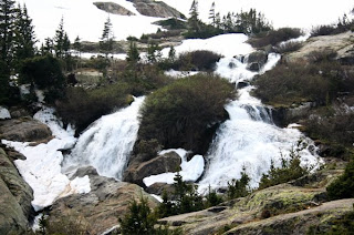
 Quandary's North Face- Inwood & Quandary Couloir
This dirt spur road will gradually curve around and end up on Quandarys north side. Stick to the road and stay left at mile 1.5 for mentioned reasons.
The road will end in a small parking area.
The approach trail is a mish-mash of easy to follow hardpack and meandering primitive.
There is some private property holdings on this side of the mountain. You'll notice plenty of private property signs and old mine shacks at 11,300ft (3,352m) on the left.
From what I've been told, don't intrude even out of curisoity. The owner doesn't suffer trespassers.
The trail courses through forest and weaves up a small rocky broken cliff and eventually tops out at an unnamed lake at 11,920ft (3,633m).
Quandary Couloir at this point will be immediately apparent as the major gully running from the higher summit ridge. It is located west (right) of the north face (Inwood Arete) route.
Simply scramble across the rocks and small stream to the apron of the couloir and get ready for some snow!
McCullough Trailhead is not maintained in winter and chances are, come spring, will still not be passable for vehicles. However, due to snowmobile and nordic ski tracks, a decent trail should be laid out for easier travel.
Climb/Route
 In the couloir
In heavy snow years, the apron will extend almost to the tarn. But in normal spring conditions, expect the apron to take up about ¼ of the total climb.
The couloir itself starts out pretty wide with a broad apron. However, even in the center of the gully, the couloir never really constricts in the sense of the word. There's a small section just below half-way where the pitch increases temporairly and narrows in between a prominant rock band and two smaller rock croppings on the left but the pitch lessens again past this 40ft section. Fact, it's fairly similar in width to Dead Dog Couloir on Torreys Peak.
There are a few mild twists and a very gentle dogleg that will prevent you from being able to clearly see the exit or the botton once 'committed'.
In the top ⅓ of the couloir, the angle will steepen slightly but open up again. A straight course with a slight, left-leaning angle to the exit will have the gentlest pitch. If you stay to the right near the rock bands, the pitch will steepen but nothing exceeding 45°-47°.
The couloir will exit on a rolling lip fairly close to the exit point for the Inwood Arete. From here, it's still another 10-15 minute walk to the summit.
Descend the East Ridge Route and walk the couple miles back to the McCullough Trailhead or where ever you parked along this road. If the snow conditions are good and stable, don't entirely rule out a fun glissade!

Quandary Couloir is a good choice for the more confident beginner snow-climber.
Equipment
 Quandary Couloir
Since this is your standard, typical moderate Colorado snow climb, other then the standard clothing for snow climbs, a mountaineering axe and crampons are the only necessary pieces of equipment you'll need.
Leave the ice tools and pro/rope at home.
As with all couloirs, expect higher winds and [possibly] warmer temperatures once you crest the top to the summit ridge.
Dress appropriately!
External Links
Interactive Topo Map via 14ers.com
Some really good graphical and topo information on McCullough Gulch and the approach.
Bicycling.com (I know, weird place for hiking beta. Takes a few minutes to load.)
Mountain Travel Guide
McCullough Gulch photos (summer time)
Good trip report from May of 2008
Miscellaneous
| USFS | Arapahoe National Forest |
| Pike National Forest | |
| USGS | Breckenridge |
| Quad | Breckenridge |
| County | Summit |