
|
|
Route |
|---|---|
|
|
43.11480°N / 42.46310°E |
|
|
Mountaineering |
|
|
Most of a day |
|
|
PD/1B |
|
|
Approach
 On the walk in
Uyatau is one of the easiest peaks to recognize in the valley. If in doubt, ask the rangers in the hut at BC. It may sound stupid, but I met people who had a target for the day, but couldn't navigate to it becasue of the density of peaks in the area.
Walk down to the main valley and either cross the river where you can find a fording place or walk up to where the glaciers starts and walk over it on the ice. Needless to say; you have to be careful using the second alternative, but sometimes it's necessary as the glacier melt-off can fill the river to its brim.
Regardless of which alternative you choose, you should aim for a steep scree section on the other side. Swithback trails are visible from far away, so you can't miss it.
When on top of the scree, walk right along the ridge until you hit snow and ice. Here you have to walk slightly to you left. Keep close to the cliffs here, but also pay attention to rock falls and falling peices of ice. Make a half circle around the little hill on your right and leave the rock face when the route towards Uyatau is obvious, i.e. when you see the peak again. You have to be careful crossing the glaciers to the foot of it. Some crevasses are completely hidden, some are visible.
Route Description
 On the climb
When at the foot of the west crest, have a close look at the route above you. I thought I had studied it quite well, but to my surprise I didn't see a middle sized crevasse on the lower section of the face. Crevasses come and go, but a good guess is that the large one just over some rocky outcroppings will be there for some more years. When you have crossed this one, traverse to the right hand side of the snow covered "mini-face". It gets steeper and steeper until you arrive at some rocks. I would say the slope has a maximum of 40 degrees at its steepest part.
Negotiate the rocks. Some of them felt a bit loose, like they could becam unloose on a warm day. Now it'll get flatter and flatter until you reach the summit. The last part is first a mild gradient snow walk and the final meters are on large rocks.
Enjoy the views of the nearby Gumachi!
Essential Gear
Crampons, ice ax, walking poles (preferable of the type where you can take off the basket, so it can double as a crevasse finder), glacier goggles and provisions for a day.Some may want to rope up on the steepest sections of the peak, as the fall will be long and fatal if something goes wrong. A mid-length snow stake may also come in handy, if you want to play it really safe.
Traversing or descending via other routes
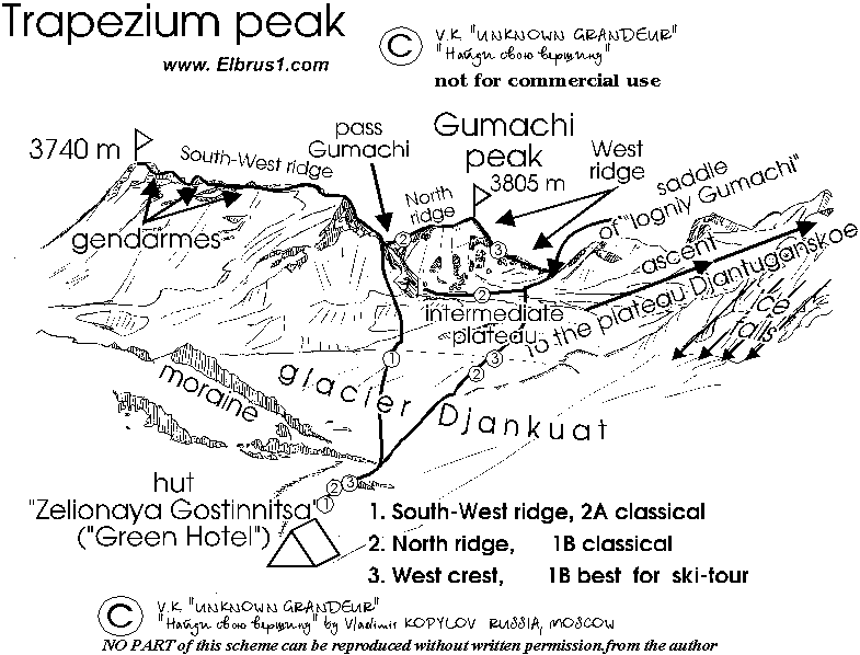
The peak offers some interesting alternatives and if you're a strong climber you may want to go for a second peak the same day. Here are some basic info about alternatives.A simple sketch of routes on Uyatau and also some on Gumachi and the rest of the valley.
Uyatau is called Trapezium on this sketch.