My 12-year-old son and I set out on August 14, 2009 to hike to Eccentric BM/Chepeta Peak. After reading the information on the SP website, we decided to take the Spirit Lake route rather than the apparently more popular Chepeta Lake route. It took us about 3 hours to get from Salt Lake City to Spirit Lake, using the directions on the SP website, traveling through Mountain View and Lonetree, Wyoming. Spirit Lake is a beautiful spot, and the roads up there are very good all the way. We saw plenty of passenger-type cars up there. Anyway, there is a Forest Service campground at Spirit Lake, as well as plentiful places to camp outside the official campground. We selected a spot in the campground, set up our tent, and cooked a nice evening meal. The weather was great, cool and crisp and nice. We turned in at about 9 pm, hoping the weather would hold.
But it didn't. Soon after we crawled into the tent, it began to rain, and rained heavy and steadily for several hours, with loud thunder and bright lightning and the constant patter of rain on the tent. We didn't get much sleep. When the alarm went off at 5.30, I crawled out of the tent and saw that the skies were clear, winds were calm, a quarter moon was out, and many stars were visible. The weather looked promising, so we decided to give it a go. We quickly ate some food, gathered our things, and were off at 6.15.
There is no trail at any point on this route, and route-finding skills are required.
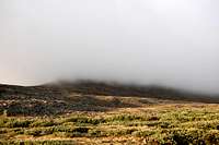
The route initially calls for a southeasterly course up through a forest to the top of the ridge east of Spirit Lake. We took a compass reading and headed into the trees headed SE. The forest is not dense and it is fairly easy going up to tree line at the top of the ridge. As we emerged from the trees, and onto the top of the ridge, we could see the sun rising in the east behind Flaming Gorge Reservoir. We could also see that the subpeak in front of us, known as Daggett Peak, was shrouded in what looked like wispy fog; these clouds were low and did not extend very far above the peak tops.
It looked to me like the fog was just residual leftovers from last night's storm and would burn off quickly once the sun rose. It certainly didn't look like anything to worry about, and we headed up the north slope of Daggett Peak.
Soon we were in the fog, and visibility was very low. The north side of Daggett Peak is largely composed of boulder fields that are very tedious to negotiate, and in the fog it was difficult to pick the most efficient path up through them. It took us a while, but we eventually reached the top of this subpeak.
There we found five or six cairns, some of which looked kind of spooky in the fog. We stopped for a brief rest, and headed down the south side of Daggett Peak.
After descending a few hundred feet down the grassier southern side of Daggett Peak, we came to a saddle and began to climb upward again. The route during this stretch was not hard to follow, even in the fog, because all we had to do was keep the cliff in sight on our left and gently round the corner and turn to our east. We climbed gently upward, over several different points that, in the fog, we thought were summits but turned out to be false ones. We just kept climbing steadily upward, thinking that the highpoint should be fairly easy to find: you just keep going up until you can't go up anymore.
After some time, we came to a big flat area that, in the fog, looked to be several hundred yards wide. Visibility was so low that we couldn't really tell if we were at the top, and the slope had become so gentle that we couldn't really tell if we were going upward or downward. We couldn't see any cairn or summit marker in the fog, and so we wandered around in the fog on the summit area for 15 or 20 minutes, searching for one of the two benchmarks that the map told us existed in the summit area. In our searching, we both got kind of turned around up there, and it became difficult to tell which way was north.
Finally we found the rock shelter housing the Eccentric BM. It was actually kind of a relief to find it, because for a few minutes there I began to doubt our ability to find it. It was 9.00 am when we finally found the BM, and we took a rest and had a snack and a drink.
We didn't want to stay very long, though, because it was cold up there in the fog.
![Eccentric BM]()
Ice crystals were developing on anything with even a bit of moisture on it: backpack straps, the edge of the camera lens, even my baseball hat that I had strapped to the back of my pack. I would guess that the temperature was right around freezing, maybe a bit below, with a little breeze making wind chill somewhere in the 20s. And this is in August! Anyway, we decided to leave and hike down, but we had a problem: in the fog, we had no idea which way was north, and couldn't really remember, after all of our wandering around the flat summit zone, which way we had come from. The sun was not at all visible through the fog, and it could lend no clue as to the direction. We had a compass with us, and took several readings, but it was acting funny until I figured out it didn't like my camera being in its immediate vicinity. We were still not quite sure about the compass, so we tried to locate the Chepeta BM to give us a bearing, but after 15 minutes or so of searching, were unable to find the Chepeta BM in the fog. Finally we decided to just trust the compass, and we headed off in what we thought was a westerly heading back toward Daggett Peak.
Nothing looked familiar in the fog, and we weren't 100% sure we were headed in the right direction until we came to the saddle and started back up the south slope of Daggett Peak. It was a relief to see those spooky cairns again and know for certain that we were on the right return path. By the time we got back to the subpeak, the wind had picked up, and we thought the weather might begin to worsen. When we had last been down on the northern slope of Daggett Peak near tree line, it had been a beautiful morning (at least below the fog line). But as we made the tedious descent down the north slope of Daggett Peak, through the boulder fields, we did not ever reach the fog line. The fog persisted.
Right as we reached tree line, we heard our first peal of thunder. About 5 minutes after we re-entered the forest, precipitation began to fall, but it wasn't rain, it was some sort of sleet-hail mixture, and it soon was coming down hard. I was very very glad we had reached tree line by the time the sleet started, and that we were no longer up on top.
We continued down through the forest, and the sleet continued.
We finally got back to our campsite at Spirit Lake at about 11.30 am. The campground had been about 2/3 full the night before, but it was deserted now, except for our tent, which now had a nice covering of snowy sleet on top of it. We still had to break camp and pack up the tent, and by the time we got all of that done there was a couple inches of the snowy sleet on the ground. It looked like a winter wonderland---in August.
Others who have taken the Spirit Lake route to Eccentric BM have said that it is a scenic and pleasant hike. And that may well be true, in good weather. But this hike was harder than we had bargained for, and came with plenty of route-finding stress in the fog. We managed to bag our 25th (out of 26) Utah county highpoint, but it was quite the adventure doing so. To be honest, we were plenty glad to put this one behind us.


Comments
Post a Comment