
-
 16874 Hits
-
 78.27% Score
-
 9 Votes
|
|
Canyon |
|---|---|
|
|
38.19522°N / 109.84764°W |
|
|
Hiking, Scrambling, Canyoneering |
|
|
Spring, Summer, Fall, Winter |
|
|
Overview
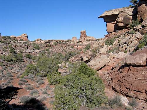
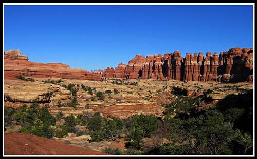
Elephant Canyon is a scenic canyon in the Needles District of Canyonlands National Park in Utah. This canyon drains northward with its headwaters located at the famous Druid Arch and flows through much of the Needles District and entering the Colorado River 3 miles north of the confluence with the Green River. The upper section of the drainage is hiked by thousands of people every year who head to see Druid Arch which is an incredible sight. The lower section of the canyon which drops steeply to the Colorado River has probably only been traveled a few times as it requires some tough route finding, a couple short rappels and one long, 80 foot overhanging rappel.
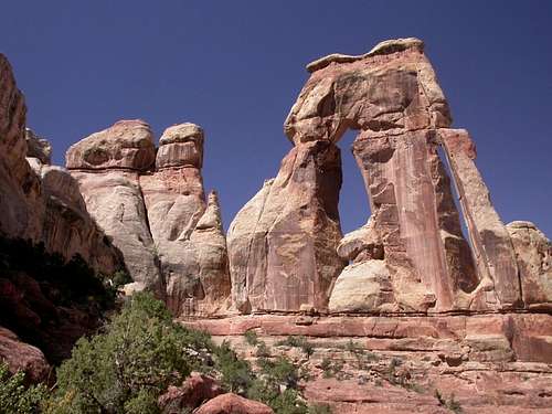 Druid Arch Druid Arch | 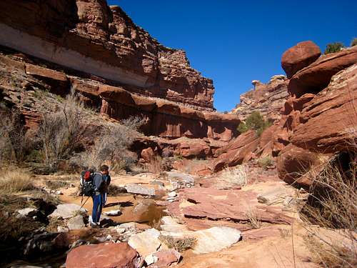 Elephant Canyon Elephant Canyon |
Getting There
This canyon is located in the Needles District of Canyonlands National Park. The nearest town is Monticello but the majority of people use Moab as a base for any adventures in all of southeastern Utah. There is a fantastic hostel in Moab called the Lazy Lizard Hostel which has beds for $11 per night and you almost always meet cool people who like to travel, hike and climb. From Moab, head south on US Highway 191 for 40 miles to a distinct rock formation called Church Rock and turn right (west) on Highway 211. If you continue past this junction for 15 more miles you'll come to the town of Monticello where you'll find a few places to eat and a couple motels. The visitors center in town allows you to park in their lot if you are meeting other party members there.
This canyon is pretty long and extends from Druid Arch in the southern portion of The Needles north to the Colorado River. Therefore there are two trailheads you can use depending on which part of the canyon you wish to visit. If you want to visit the upper portion which isn't much more than an easy hike in a wide dry wash, you'll use either the Squaw Flats or the Elephant Hill trailhead. For the lower part of the canyon which offers a moderate technical canyoneering adventure, use the Big Spring Canyon Overlook trailhead.
Lower Trailhead (Big Spring Canyon) - Head west on 211 and enjoy the scenery as you begin descending to Indian Creek. The Wingate sandstone walls all along this road offer some of the best crack climbing in the world so take the time to climb a few of the classics if you have some extra time. 35 miles from Highway 191 you will reach the Canyonlands NP visitor center and an entrance station where they charge $5 to enter the park. Continue west for an additional 5 miles to the end of the road at the Big Spring Canyon Overlook. Do not turn left on the road heading to the Elephant Hill Trailhead. Park here along the side of the road (there isn't an official parking lot).
Upper Trailheads - Once inside the park, pass the visitor center and just past the turnoff for Wooden Shoe Arch and the Cave Spring Cave trailhead, turn left onto the Elephant Hill Road. This is right as the main highway turns back to the north. For the Squaw Flats trailhead, simply drive about 1 mile to the end of the road where a large parking area is located. For the Elephant Hill Trailhead, turn right a quarter-mile from the highway and follow this narrow but paved road as it winds it way west, crossing the Big Spring Canyon drainage and ending in a gravel parking area at the base of Elephant Hill.
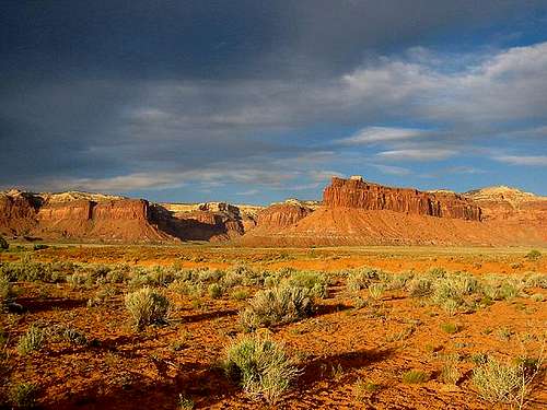 Indian Creek sunset Indian Creek sunset | 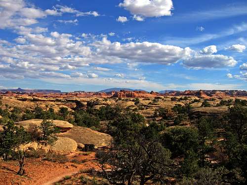 Elephant Hill Elephant Hill |
Lower Elephant Canyon
For the lower, technical part of Elephant Canyon, start at the Big Spring Overlook Trailhead and follow the Confluence Overlook Trail as it descends a couple hundred feet to the Big Spring Canyon bottom, crosses it and continues west up a side drainage. Pass through a narrow spot between a couple large rocks and continue west over a wide, flat bench. The trail crosses the Elephant Canyon drainage about 1.5 miles from the trailhead. Leave the trail here and turn north and follow the wide dry wash for an additional mile to the first big drop. you don't have to rappel this 150 foot drop but instead hike on the west rim about 700 feet to a very small side drainage and drop into it. Rappel 30 feet down the short overhang from one of the juniper trees. We found a good tree about 50 feet back from the lip and put a sling on it. Make sure you are able to pull the rope before everyone comes down.
 Leave trail here where it crosses Elephant Canyon Leave trail here where it crosses Elephant Canyon | 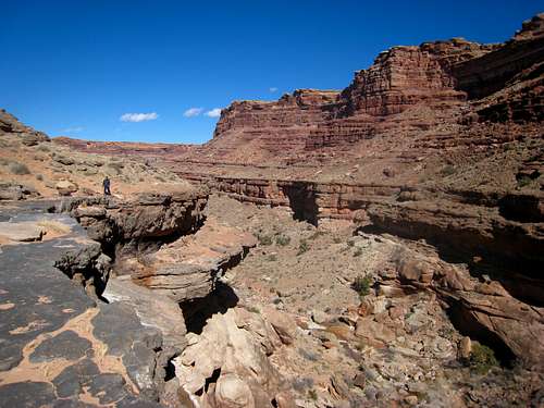 First big drop and hiking along the west rim First big drop and hiking along the west rim |
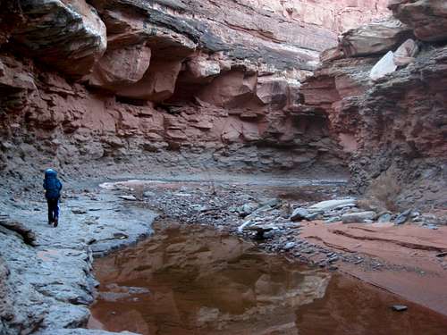
Once down, hike down boulders and scree back to the canyon floor and continue hiking down canyon. A half mile from the rappel you will notice a larger side canyon head off to the south (left) which offers an alternate entry or exit to the main canyon (pink line on map below). Just beyond this, reach the second big drop which also doesn't need to be directly rappelled but you can walk along the west rim again for 800 feet or so where you can scramble down and make a 12 foot down climb onto the talus below. This descent is tricky and it's best to lower the first one down and have them spot the remaining party members as they make the 5.4 climb down. Some people may be comfortable simply jumping down but that isn't recommended.
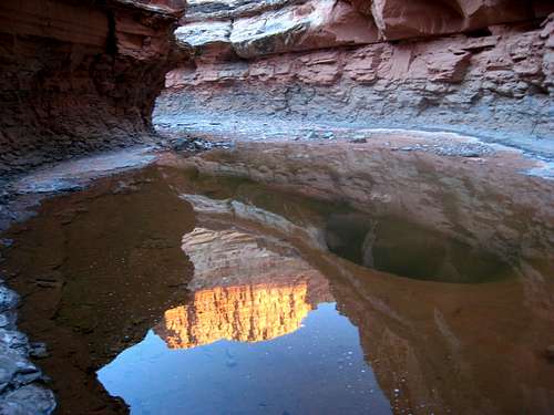
Once everyone is down, descend the talus to the canon bottom and continue hiking north until the canyon begins to narrow and you come to the unavoidable 80 foot rappel. Find the anchor by scrambling to the right side and over a small ledge to a large boulder sitting under an overhang. We put a black sling around an excellent horn on this car sized rock and made the overhanging rappel 80 feet to the pool of water below (which is easily avoided). Be careful on the start of the rappel and if you have overnight packs, consider lowering them first.
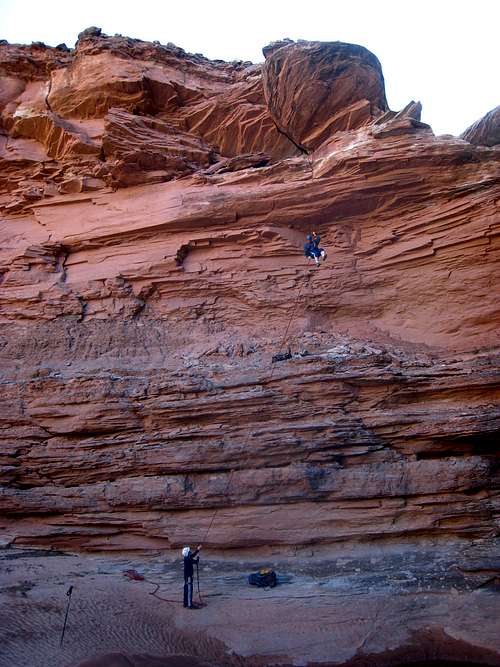 Scott making the 80 foot rappel
Once down the big rappel, the canyon opens up and there is a bunch of boulder hopping. Be sure to notice the fossils and chert found in nearly every boulder in the canyon. Thousands of Crinoids along with red and black chert. Just before reaching the Colorado River, there is one more drop you can bypass by hiking along the east rim to a talus slope which takes you down to the Tamarack bushes and green grass below. Right before you reach the river, look up 50 feet or so on the right side and locate some old indian ruins. Upon reaching the Colorado River, you have to decide your fate. The best way to return is to turn right and hike east for 0.5 mile up the river to the mouth of Salt Creek (Red line on map below). This half-mile hike really sucks and is only recommended in fall or winter when the river level is low. The bushwhacking through the Tamarack bushes and scrambling on loose rubble is tedious and requires some good route finding as you will have to climb up and over some small cliff bands. It will likely take at least an hour for this stretch.
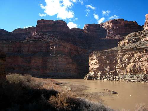 Colorado River at the mouth of Elephant Canyon Colorado River at the mouth of Elephant Canyon | 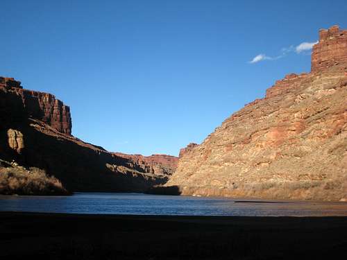 Colorado River at Salt Creek Colorado River at Salt Creek |
Salt Creek Return Route
Once you reach the mouth of Salt Creek, begin hiking up the wash which should be dry in fall and winter. Follow the deep canyon up as it makes a broad U turn and slowly works its way east. Salt Creek has five drops you will need to climb up. Four of them are easy scrambles but the second one as you head up canyon, located about 1.5 miles from the river, requires a 20 foot, 5.6 up climb which often has a waterfall flowing next to it. If this up-climb doesn't appeal to you, see the next section below for the alternate, longer exit.
This climb heads up the rock just to the right of the waterfall. Unfortunately, the rock is typically damp and doesn't have the best holds but it is certainly climbable. The only options for protection are some knife blades which fit very well into the very narrow cracks. Be sure the last climber removes them. There are a couple bolts and a sling at the top of the climb which people usually use to make the rappel. Use these bolts as a belay anchor.
 Salt Creek Salt Creek | 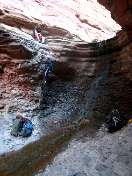 Salt Creek up-climb Salt Creek up-climb | 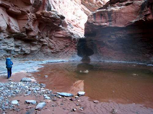 Salt Creek Salt Creek |
 Salt Creek reflection Salt Creek reflection | 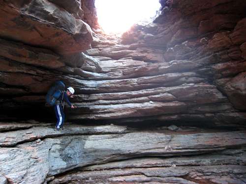 Scrambling up one of the easy drops in Salt Creek Scrambling up one of the easy drops in Salt Creek | 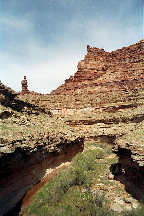 Lower Salt Creek Canyon Lower Salt Creek Canyon |
Once above the climb, continue up canyon as it gradually opens up and passes by three more short scrambles which may be damp. Water is easily found in this canyon most of the year which can be filtered for use. Excellent camping is found on a flat bench a few minutes above the up-climb. Most people would likely want to take two days for Elephant Canyon but it can certainly be done in a long day. One mile above the 20 foot climb there will be a large junction and you will want to turn right and continue south up the Big Spring Canyon drainage to return to your car at Big Spring Overlook. Do not continue up Salt Creek. A short ways further, turn right again at another junction to stay in Big Spring Canyon. You will come to a big drop you can avoid by hiking up a trail on the west side marked by a cairn. The final mile and a half gets rather bushy. Immediately below the parking area, you will one again have to climb 50 feet up a buttress on the southwest side of the canyon to bypass one last drop (which is the one seen from the parking area overlook). There is a short 4th class spot to gain a wide ledge which is followed around and above the canyon bottom. Once past the drop, descend back to the bottom and meet the trail back to the cars.
Gear Needed
For lower Elephant Canyon and a return in lower Salt Creek you will need one 60 meter rope, a couple knife blades (or just have someone spot the climber), harnesses, helmets, sturdy shoes and overnight gear if you plan to stay the night. A water filter is also a must have.
 Big Spring Canyon from the parking area - Photo Credit Adam Elliot
Alternate Exit
If you don't want to climb a wet, slippery 20 foot wall, there is another way you can climb out of Cataract Canyon and return to the parking lot, but it is longer and requires more hiking along the Colorado River. At the mouth of Elephant Canyon, instead of turning right and heading up river, turn left and begin hiking down river. Hike along the riverbank or perhaps have a raft and go 1.7 miles down river where you will reach a large side canyon just after a small rapid in the river where a huge rock slide constricts its flow. Start scrambling up this side canyon and when it forks at 4,200 feet, continue up the left fork. Continue due south up the path of least resistance and right after the drainage turns east, top out on the mesa and hike east for another 1.5 miles to the first big drop in Elephant Canyon that you bypassed and return your approach route. A topo map of this exit is shown below the overview map as the green line. Be prepared for lots of rough boulder hopping on this route which can be tedious with a heavy pack.
 Hiking up the rough side canyon on the alternate exit
Upper and Middle Elephant Canyon
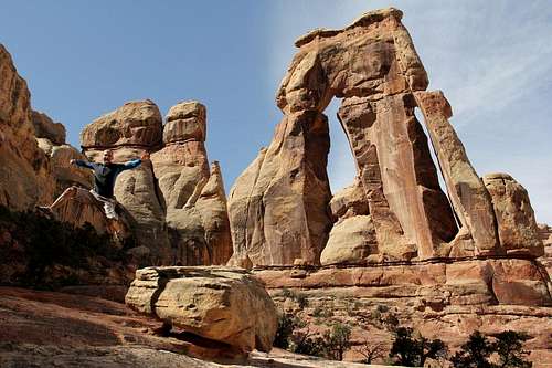
Upper and Middle Elephant Canyon is all easy hiking terrain in a wide canyon with beautiful scenery. Upper Elephant is a very popular hike as thousands of people every year hike to Druid Arch at the head of the canyon. This is one of the most unique arches in the entire state and a real marvel to see. Start at either the Squaw Flats or Elephant Hill trailheads and hike the network of trails to Druid Arch. If you start at Elephant Hill, you will head south on the Chesler Park Trail for 1.8 miles where it will meet the Elephant Canyon drainage where you can then continue south on the trail to Druid Arch. If you start at Squaw Flats, you'll hike the more scenic Big Spring Canyon Trail for 3.5 miles where it meets the Chesler Park trail a half mile before reaching Elephant Canyon. From the junction with the Upper Elephant Canyon trail, it is 3 more miles up Elephant Canyon to Druid Arch and you'll pass the Big Squaw Canyon Trail junction along the way.
Middle Elephant Canyon is not visited much but is the section between the trail to Druid Arch and the where Confluence Overlook Trail crosses it shortly before the first big drop in the lower section. It's isn't that exciting and a very sandy and hot hike.
 Druid Arch Druid Arch | 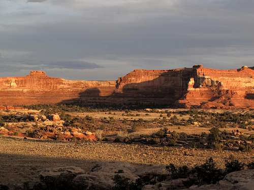 View from Squaw Flats TH View from Squaw Flats TH | 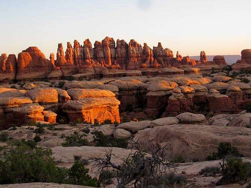 Classic Needles Classic Needles |
Overview Maps
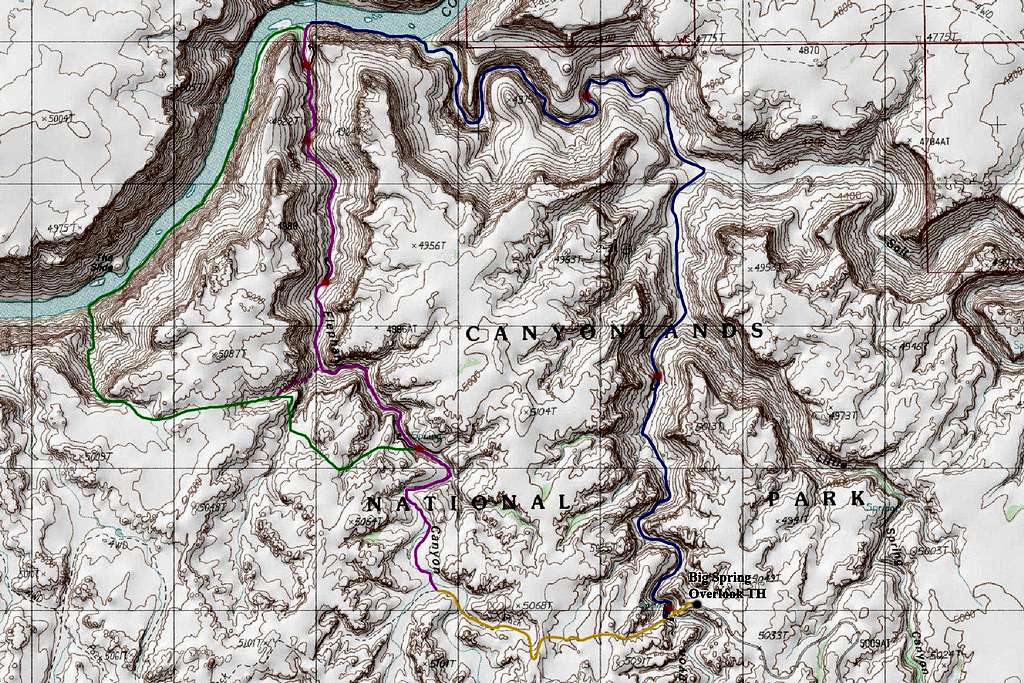
Shown below is a map of the entire Elephant Canyon drainage with key features labeled.
 Lower Elephant Canyon Detail Map
ORANGE: Confluence Overlook Trail Approach to Elephant Canyon
PURPLE: Lower Elephant Canyon
BLUE: Lower Salt Creek Return Route
GREEN: Alternate Return Route
RED DOTS W/BLACK ARROWS: Big Drops and the Bypass Route
RED AND BLACK DOUBLE DOTS: Big Drops that must be Rappelled/Climbed
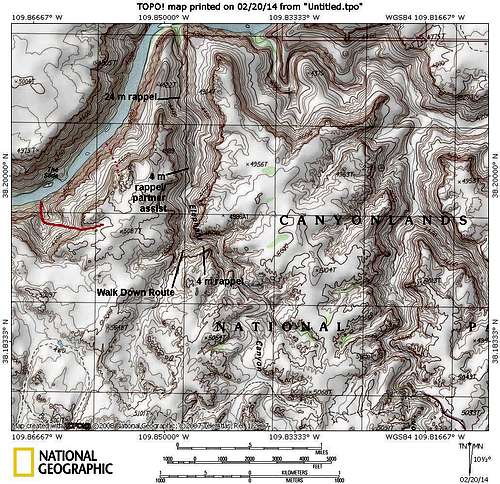 Another Elephant Canyon Map - By Scott
Camping/Red Tape
This is a national park so camping is regulated. However since this canyon is located off the trail system, you don't have to reserve a specific camping site. Just inform the ranger you will be in the Needles North Zone when you file for your permit. Unfortunately, camping permits cost $30 in Canyonlands National Park which is on top of the $5 entrance fee and you must obtain them at the ranger station or call ahead. If you come in winter though, you don't have to pay the fee to camp or enter the park as the visitor center is closed. Simply fill out the form at the self serve station at the visitor center parking lot and keep a copy with you.
Great camping can be found in Salt Creek above the 20 foot climb and along the Colorado River at the mouth of Salt Creek where a large sand bar is exposed when the river level is low. The river water is terrible though so it's probably best to camp somewhere in Salt Creek or along the mesa top on the alternate exit. Do not install bolts or leave pitons anywhere in the park. If you use pitons to protect the up-climb in Salt Creek, please remove them.
For more information on red tape, call the Backcountry Office at (435) 259-4351. Note that the rangers will tell you it is impossible to reach the Colorado River from the trailhead but that is complete bologna.
Seasons
Fall and winter are by far the best seasons for a trip into lower Elephant Canyon and Salt Creek. At this time, the Colorado River water level is low and makes it "manageable" to hike along the river bank. If you are sticking to the upper part of the canyon, anytime of year is good but July and August will be miserably hot with little shade relief and no water.
 Perfect conditions in October
External Links
Elephant Canyon on American Southwest