The first "Yankee" ascent
P. 112
A DESCRIPTION OF NATARDIN OR CATARDIN MOUNTAIN-BEING AN EXTRACT FROM A LETTER, WRITTEN BY CHARLES TURNER, JUN. Esq, IN THE SUMMER OF 1804, WHICH WAS ONE OF THE SEVERAL SEASONS IN WHICH HE HAS BEEN EMPLOYED IN THE INTERIOR, AND NORTH OFTHE DISTRICT MAINE, AS A SURVEYOR.
On Monday, August 13th, 1804, at 8 o’clock A.M. we left our canoes at the head of boat waters, in a small clear stream of spring water, which came in different rivulets from the mountain, the principal of which (as we afterwards found)issued from a large gully near the top of the mountain. At 5 o'clock, P. M we reached the summit of the mountain. Catardin is the southernmost and highest of a collection of eight or ten mountains, extending from it north east and north west. Round this mountain, on the west, south and east sides is a table land extending about four miles, rising gradually to the foot of the mountain. This table land is much elevated and overlooks all the country except the mountains; when viewed from the mountain however it appears like a plane. Leaving the tableland and following a ridge, we endeavoured to gain the summit, at the west end, which appeared most easy of access. From the head of the table land, which we considered as the base of the mountain, we ascended on an elevation, making an angle with the horizon of from 35 to 46 degrees, about two miles. This mountain is composed of rocks which appear to have been broken or split. The rocks, except at and near the top, are of a course grain, of light grey colour, and most of them are crumbling, and of these crumbles the soil, if such it may be called, is composed. The rocks near the top are of finer contexture and of a bluish colour. The table land was formerly covered with wood of various kinds; with hard woods near the streams where the soil was good: but with spruce in other parts, the trees lessening in height we approached and ascended the, mountain, until they came dwarfs of only two feet in height, and finally came to nothing at about a half mile from the summit. The rocks and soil in the ascent were covered with a deep green moss. The tableland and mountain on the south and east have been burnt over, and are entirely bare except near the springs and streams. The ridge between the streams on the west seemed to have escaped the fire, and this circumstance enabled us to ascend with greater facility. The south and east side were from their steepness inaccessible. Having reached the top, we found ourselves on a plane of rocks with coarse gravel in the interstices, and the whole covered with a dead bluish moss. This plane, the westerly part of which was very smooth,
16 yol VIII.
p. 114 DESCRIPTION Of MOUNT CATARDIN.
and descending a little to the northward, contained about eight hundred acres The elevation was so great as sensibly to effect respiration. The day was very calm and sultry, and our toil so great, that when we had found s springs of very clear cold water, oar company were inclined to drink of them too freely. Some felt the ill effects immediately, and others were taken with vomitting in the course of the night following; indeed our whole company, which consisted of eleven, found, on the following morning, our throats sore and inflamed. Whether this arose wholly from some ill quality in the water, ‘or partly from eating a variety of fruits, such as raspberries, blue whortleberries, black currants, boxberries an& bog cranberries, which we found in abundance from the place’ where ‘we left our boats to near the top, we could not determine. Though to us, in our thirsty and fatigued condition, the pure spring brought to our minds the fabled nectar of the poets, yet we found that it had a very perceptible astringent and appeared to be impregnated with minerals.
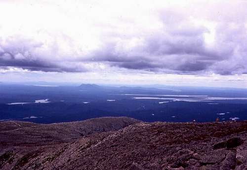
Having arrived at the highest point, which is towards the east end, we found ourselves above all the mountains within our horizon. We could not determine our actual elevation, not having instruments, nor being otherwise prepared to measure the height of the mountain. From this point our view was, enchanting; the air however had during the day become a little smoky, which prevented our distinguishing distant objects with that clearness which we could have wished. The plane on the top of the mountain, being nearly a mile and an half in length, would have afforded a base or leg, by which, with correct instruments, we might have determined with a great degree of exactness, the situation and distances of all the principal highlands and mountains in the District of Maine, and the situation and extent of the principal lakes. Here we could see, due north from us, the lake or cross pond, which is the main reservoir of the Aroostook branch of St. John’s River, and several smaller lakes. Here we could see, bearing N. W. the lake at the head of St. John’s River, (the lake that is sketched on our map
![Moosehead lake is the long...]()
DESCRIPTION OF :MOUNT CATARDIN. Page 115
Of the district of Maine, N. W. from Moose-head Lake.)
West from us, we could see the south end of Moose-head lake, and N.N.W. its north end, a chain of small mountains lying N. of Piscataquis mountains preventing our seeing its centre. Near the westerly part of the mountain which is connected with the Catardin, we could see Chesauncook lake extending N. N. E. and S.S.W. about twenty miles long and five miles broad which empties in to the Penobscot; and south of it; a large 1ake N. of. The E. end of the Piscataquis Mountains; which empties into the Piscataquis River. We counted sixty three lakes of different dimensions which discharge their waters by way of the Penobscot. S. W. from us lay the
Piscataquis Mountains extending E. and W. nearly, from the Penobscot to the Kennebec: and N. of the lands surveyed, lay a small ridge of mountains, about, twenty miles N. of the Piscataquis mountains amongst the collection of Mountains near the Catardin, is one lying N.N.W. called by the English Fort Mountain, from its shape: its base being an oblong square or parallelogram extending N.E. and S.W. and ascending at the sides and ends in an angle of about 45 degrees to a sharp ridge; which ridge is about one mile in length, and is covered with verdure. North of Fort Mountain appears an irregular mountain on the south side of which, and, near the top, appeared an extensive ledge of smooth white .rock which glittered like ising-glass. We could clearly discern the highlands, from the Bay of Chaleur westerly which divide the District of Maine from the Province of Quebec. E.N. E. from us lay Peaked Mountain, over which Bingham's easterly line runs. Mount Desert was also distinctly in view. We could clearly discern the range of high fertile lands extending No. and So. between the Penobscot and Scoodic waters; and those between the Penobscot and Aroostook waters, and the St. John’s River. But the sun was now declining in the west, and we took leave of the summit of the mountain after having deposited the initials of' our names(William Howe, Amos Patten, Joseph Treat, Samuel Call, William Rice Richard Winslow, Charles Turner Jun.) and the date cut upon sheet
p. 116 DESCRIPTION OF MOUNT CATARDIN
lead, and a bottle of rum corked and leaded, on the highest part. We descended the mountain with cautious steps, until we came among the low spruces, and the next day at noon we reached our canoes.
It is difficult by any orthography, precisely to express the name of this mountain, and convey the nasal sound which the natives give. No-tar-dn or Ca-ta-din is as near perhaps as the powers of the letters will admit.
The Indians have a superstition respecting this mountain, that an evil spirit, whom they call Pamola, inhabits it, at least in the winter, and flies off in the spring with tremendous rumbling noises. They have a tradition, that no person, i.e. native, who has attempted to ascend it, has lived to return. They allege, that many moons ago, seven Indians resolutely ascended the mountain, and that they were never heard of afterwards, having been undoubtedly killed by Pamola in the mountain. The two Indians, whom we hired to pilot and assist in ascending the mountain, cautioned us not to proceed if we should hear any uncommon noise; and when we came to the cold part of the mountain, they refused to proceed ahead —however, when they found that we were determined to proceed; even without them, they again went forward courageously, and seemed ambitious to be first on the summit. On our return to Indian Old Town, it was with difficulty that we could convince the natives that we had been upon the top of Mount Catardin, nor should we have been able to satisfy them of the fact, so superstitious were they, had it not been for the Indians who had accompanied us. END OF TURNER NARRATIVE
Charles Turner, of Scituate, Mass. was later elected to the U.S. House of Representatives and this extract from his letter was published in the Collections of the Massachusetts Historical Society Vol 8 (second series). The volume I got it from was vol 18 published about 1819-1820. It appears he followed the route of the Appalachian Trail. Turner Mountain is not named for Charles Tuner. His efforts were used by the U.S. and Massachusetts in the Maine Boundary dispute with Britain of 1783-1842. The mountain’s east side, basins and Knife Edge are not described save to say it’s steeper. The fire he mentions occurred in 1795. The mountain is John Gyles’ Teddon of 1690, Chadwick’s Mt. Todden of 1763 and Thoreau’s Ktaadn of 1846. I’ll paste in some pix later.
External Links
Add External Links text here.
Comments
No comments posted yet.