
-
 38540 Hits
-
 93.1% Score
-
 41 Votes
|
|
Route |
|---|---|
|
|
Hiking, Mountaineering |
|
|
Summer |
|
|
A long day |
|
|
Primarily GNP Class II and III |
|
|
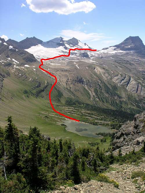
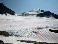
The portion of the route leading from Mary Baker Lake to Comeau Pass. Note in particular that on the initial ascent from the lake to the glacier basin, the best route remains in the meadows below the prominent bands of cliffs (the dark diagonals above and to the left of the red line). Photo by Glacierscrambler.
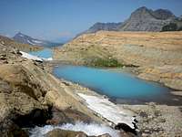
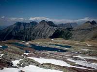
Meltponds below Sperry Glacier
Overview
The Floral Park route, which links Logan Pass (6646 ft.) to Lake McDonald (3153 ft.) via the Sperry Glacier basin and Comeau Pass, delivers a veritable checklist of things to see while you are on this earth: glacial lakes and melt-ponds in mind-bending shades of blue and green; snowfields and glacier stained red by snow algae and pockmarked by fallen ice and rock; mountain goats blithely traversing sheer rock-faces; and, of course, the stunningly defiant wildflowers that thrive in this seemingly so inhospitable alpine climate. Indeed, Floral Park is no misnomer: when spring finally thaws the high reaches of the Lewis and Clark Range (mid-July or even August, depending on conditions), wildflowers flourish in the steep meadows alongside Mary Baker Lake.
Hiking season in the area is not much longer than wildflower season: snow keeps the route virtually impassible until well into July, and winter can arrive as early as September. Begin early in the morning if you wish to finish without a headlamp, as the route covers about 20 miles of terrain, over half of which is off-trail. The net elevation loss from Logan Pass to Lake McDonald is approximately 3,500 ft, but prepare yourself for a yo-yo course that can only be summarized as up-down-up-down-up-down-up-up-down.
Floral Park's splendid isolation can also be deadly. It is highly unlikely that you will encounter other humans between Hidden Lake and Comeau Pass (except those high above in the woefully ubiquitous sight-seeing helicopters), so travel with sufficient emergency supplies and navigation skills.
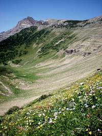
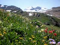 Snowy Gunsight Mountain is visible behind the flowers of Floral Park |
 Bearhat Mountain to the right of Hidden Lake. The route leads around the lake to the saddle to the left of Bearhat. |
 At the edge of the Sperry Glacier basin shortly before Comeau Pass. Left-of-center is Mount Cannon, with Clements at the highpoint on the ridge to its right. |
Route Description
Strictly speaking, Floral Park is just one segment of a much longer trek that also passes through Logan Pass and Hidden Lake, the Sperry Glacier Basin, and the dense old-growth forest to the west of Sperry Chalet. Backpacker Magazine published a sparse description of “Logan Pass to Sperry via Floral Park” in its April 2006 issue, but the authoritative source remains J. Gordon Edwards’s A Climber’s Guide to Glacier National Park, which supplies the “Hidden Lake Route” from Logan Pass to Sperry Chalets. The route that appears here adapts Edwards’s description to provide greater detail and a number of additional pointers for avoiding common pitfalls, but his guide remains an indispensable companion for off-trail travel in Glacier National Park.
The Floral Park route begins on a boardwalk. From Logan Pass, follow the Hidden Lake Trail for 3 miles over Hidden Pass and down to Hidden Lake. Ford Hidden Creek (cold, but shallow and slow-moving) and continue south along the well-worn but undesignated trail along the bank of the lake. Slightly before the lake wraps sharply to the southwest, scout the steep hillside to your right for passable drainages or meadows leading to the shoulder south of Bearhat Mountain. (Edwards describes a game trail here that is now marked with cairns, so keep an eye out; if you miss it, however, you will also do fine.)
 A final glimpse of Hidden Lake before reaching the saddle and dropping down to Floral Park. |
 In the background, the steep, grassy slopes leading from the saddle above Hidden Lake to Mary Baker Lake (lower left). In the foreground, the floral slopes leading to the glacier basin. |
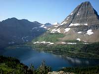
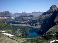
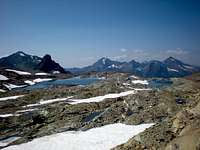
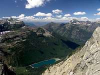 Avalanche Lake, and behind it Mount Brown. Across the valley to their right are Stanton (L) leading to Vaught (R) |
As you climb above the lake and begin wrapping around to the southwest, you will spot a broad, meadowed basin below the saddle between Hidden Lake and Floral Park. Although the prospect of dropping down to that basin may seem demoralizing after the steep scramble up from the lake, it is far easier to sacrifice the elevation than to traverse the loose scree and slick snowfields on high. Once you cross the basin, it is an easy upward stroll to the saddle.
As Edwards so memorably says here, “SURPRISE!” To spoil the surprise: from the ridge you will catch your first glimpse of Sperry Glacier, as well as most of the remainder of your route until Comeau Pass at the far end of the glacier. Detour a few hundred feet to the northwest (right, with your back to Hidden Lake) along the ridge for a vertiginous peek at Avalanche Lake approximately 4,000 ft below. When you are ready to drop down to Mary Baker Lake, continue in the opposite direction (southeast) until you find a good drainage descending steeply into Floral Park. (If you find yourself bushwhacking through dense alders along the flat ridge, you’ve gone too far.)
Mary Baker is perhaps less visually striking than turquoise-colored Avalanche Lake or the milky glacial ponds awaiting you above, but it makes for a remarkably serene place to stop for lunch or a nap. The lake is warm, shallow, and pleasantly clay-bottomed, and from the sun-soaked rock slabs on the far shore, you enjoy a fine view of the wildflowers of Floral Park.
From Mary Baker Lake, the approach to Sperry Glacier appears far more daunting than you will actually find it if you take the most direct upward course through the meadows. You may be tempted to traverse the base of the cliffs above you to the left; stifle this impulse. You will exhaust your downhill leg and waste precious time negotiating perilously brittle rock when you could be strolling through mellow fields of asters and paintbrush. Head up the meadows until you reach the lip of the glacier basin about 800 vertical ft above the lake.
The glacier basin greets you with silty meltponds that look as though they belong on the surface of another planet. Traverse along the smooth rock surrounding the ponds until you reach the rim of Sperry Glacier. Continue southeastward over the snowfields at the base of the glacier, connecting the dots between the islands of rock jutting through the snow. Your journey will be considerably smoother if you use the rim of the glacier as your guide rather than trying to stay off the snow by meandering around the gorgeous but steep and slippery meltponds below the glacier.
 A view from the traverse below Sperry Glacier, with Gunsight Mountain above. |
 To your right as you traverse is Little Matterhorn, here in the left foreground just beyond the glacier basin. |
 A dramatic reunion with the trail: the staircase leading down from Comeau Pass |
To reach the observation point above—where you will connect with cairns leading you to Comeau Pass and the trail below—you will need to climb up a short stretch of Sperry Glacier, but you can minimize that distance by traversing on relatively flat snowfields until the glacier begins to taper. On your left as you travel east, you will eventually reach a short, steep approach to the firm rock above; as you ascend the glacier, you will finally see the cairn marking the lookout. (Do not attempt to traverse all the way around the glacier and backtrack above it; the going is rough.)
When you reach Comeau Pass, enjoy a final glimpse of the Logan Pass-area peaks before descending into the man-made stairway carved into the rock. From here it’s a steep 2.5 miles of switchbacks down to a juncture slightly north of Sperry Chalet (where you can, if necessary, refresh your Snickers rations) and another 6 miles to the Lake McDonald trailhead.
Getting There
Ride the free park shuttle from Apgar or St. Mary (or designated points along Going-to-the-Sun Road) or drive to the Logan Pass Visitors’ Center. The Hidden Lake trailhead is located immediately behind the visitors’ center.
You may need to shuttle a car in advance to the Lake McDonald trailhead, as you will almost certainly finish your day after the last shuttle up to Logan Pass.
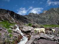 Mountain goats supervising the Comeau Pass trail leading down to Sperry Chalet. |
 A final view of the Logan Pass-area peaks, from near tiny Gem Lake at Comeau Pass |
 Akaiyan and Feather Woman Lakes, just below Comeau Pass. |
Essential Gear
An ice axe is not essential but may be desirable for crossing Sperry Glacier, as well snowfields earlier in the season. A hiking pole may also do for probing the surface of the glacier.
Water is plentiful along the route, but bring a pump or purifying tablets.
Bear spray is an excellent investment in grizzly country.
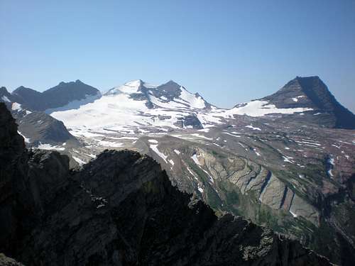
The "SURPRISE!" moment in Edwards' route description. Lying ahead are Sperry Glacier, with Edwards Mountain to the right and Gunsight Mountain to the left.
distressbark - Nov 23, 2009 11:42 am - Voted 10/10
game trail from Hidden Lake to Floral Park PassHasn't voted we were able to find the game trail leading from Hidden Lake to Floral Park Pass. we followed the west edge of Hidden Lake until the shoreline began to angle to the southeast; at this point, we cut off the climber's trail to the southwest, heading through a few wonderful small meadows with littered with large rock cairns. after a few minutes we found a very well-worn trail, which lead us uphill to a grassy, open area south of Bearhat Mountain. i'll post a few pictures to try and help with route finding.
NathalieLouise - Nov 28, 2009 10:25 am - Hasn't voted
Re: game trail from Hidden Lake to Floral Park PassThanks; good to know. I'd love to see photos of it.
alexblondeau - Dec 26, 2013 6:50 am - Hasn't voted
Re: game trail from Hidden Lake to Floral Park PassHere's a video showing the way up from Hidden Lake that we use. It may be of some help to those planning: http://www.youtube.com/watch?v=Qzsc6ShY3go
distressbark - Dec 10, 2009 8:55 am - Voted 10/10
posted two photos...that will help people find the game trail. one is of a gorgeous, lush meadow with large rock carins; after heading uphill through this meadow, you'll soon join up with the game trail. i also have a photo of Mount Reynolds behind Hidden Lake that shows the game trail in the foreground.