Prologue
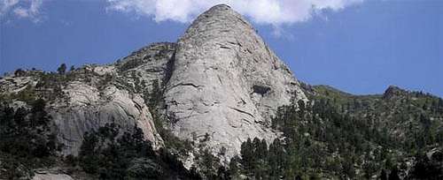
![Sugarloaf Panorama]() A view of the destination. Photo by Tom Lepinski
A view of the destination. Photo by Tom Lepinski
I have only lived in the small New Mexican city of Las Cruces for about 2.5 years, but every time I reach the crest of Highway 70 at San Augustin Pass and continue heading east I am stupefied by the giant hunk of white rock that juts into the sky on the east side of the Organ Mountains. The peak is named Sugarloaf Peak and it is so completely different from the rest of the Organ Mountains that it catches even the most casual observer’s eye. As R. L Ingraham wrote in his Climbing Guide to the Organs, “This strange peak, utterly unlike the main Organ peaks, stands in splendid isolation a mile or two to the northeast of the Needle. A cone, or sugarloaf, in form, distinctly white in hue, it is the veritable Glass Mountain of the Andersen fairy tale. The rock is hard and remarkably smooth, with occasional door knob protrusions which proliferate toward the top. It was one of the first technical climbs to be done in the Organs, conquered by the German "paper clip" scientists at White Sands Proving Ground in the far off years of the late forties.”
Originally I was under the impression that a climb of Sugarloaf would involve multiple pitches of very runout slab climbing. The only routes I had heard of on the peak were ~10 pitches and had 50-60 foot sections of runout 5.6 climbing. Coming straight off the couch after 45 hours a week of staring at computers that didn’t sound like something I was mentally ready to attack. Then out of the blue, a geocache was placed on the summit by a local hiker/cacher/climber.
I started geocaching after I moved to Ohio for a stint in grad school when it became obvious that most of my recreational activities were not going to involve mountains. It has provided a fun alternative and often gives me another excuse to get outside. Geocaching has also been a good method to help introduce my two young children to the outdoors. But I digress…
After talking to the person who placed the geocache I learned that there was a medium 4th class route that headed to the summit. I also found an older, brief description of the route on the “Climbing Guide to the Organs” website. I knew it was going to entail a long day of hiking, but I figured that a 4th class route shouldn’t offer too many challenges that Brian and I could not overcome. To ensure an early start we decided to camp at the pleasant Aguirre Springs campground located near the trailhead.
![Sugarloaf on the way to Aguirre Springs]() Sugarloaf on the drive into Aguirre Springs
Sugarloaf on the drive into Aguirre SpringsApproach Hike
We awoke at first light on Sunday morning and made the short drive over to the Indian Hollow TH. After applying sunscreen and stowing the appropriate vittles we locked the truck and started towards our dirt path. At the last second, we stopped, reconsidered our gear selection, and decided to add a few more pieces of protective gear (a couple more cams and some slings) just in case. (Author’s note: In literary parlance, I’ve been told that this is called foreshadowing).
The temperature was perfect as we started up the trail. The trail is a little difficult to follow, but previous trips on this trail allowed us to make great time for the first 2.5 miles that followed a fairly well worn trail and offered some great views of our upcoming challenges. The trail gains altitude slowly and crosses a few drainages that had a fairly steady trickle of water succumbing to the forces of gravity. After the first 2.5 miles the trail starts to become less distinct and it becomes obvious that most casual hikers make the turnaround near a large boulder on a small knoll. We took in the grandiose views of Sugarloaf, Organ Needle, and the Rabbit Ears before following the climbers path to the left towards the gully that funnels water off of the northeast side of Sugarloaf. We maintained contact with a serviceable climber’s route for a while but eventually began to follow the “path less traveled” above the gully on the east side.
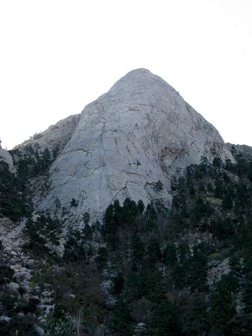
![Looking up Sugarloaf s North Face]() Occasionally we'd get a good look at the impressive North Face as we ascended
Occasionally we'd get a good look at the impressive North Face as we ascended
The progress slowed substantially as we dodged vegetation, slipped on scree, and scrambled around boulders. After a coupleof hours of uphill navigation we reached a large cairn at a wide choke point where all routes are forced to come together. I dropped off my trekking poles, which had become more of a hindrance than a help, and a liter of water.
![Choke Point on the Sugarloaf approach]() We rested and ate some snacks before continuing upward.
We rested and ate some snacks before continuing upward.
We then (wisely it turns out) decided to take the route heading to the left and scrambled up to a small saddle that offered views down into the main base at White Sands Missile Range. From here we encountered some climbing that became a little more tenuous and at one point, where the consequences of a misstep became severe, I changed into my climbing shoes for a short section.
![Terrain on the approach to Sugarloaf]() Typical terrain on the approach hike
Typical terrain on the approach hike
We gained a few hundred more vertical feet and when we encountered a large tree with numerous slings we knew that we were getting close. A short scramble brought us into the gully about 100’ below the NE saddle and we saw what looked like the “weakness in the wall” that signified the beginning of the 4th class climbing. Being accustomed to looking at a computer screen this weakness looked a little more difficult than I expected it to look. So I scrambled up to the saddle and out onto the east shoulder for a better look at the face. It quickly became obvious that the place we had identified was indeed our route. But strangely enough there also happened to be an old rope that hung down to w/in 25’ of the ground about 20 yards downhill from the start of our route.
![Start of the Climbing]() The large Ponderosa pine with slings is in the middle right of this picture. I'm standing at the start of the climb in this photo.
The large Ponderosa pine with slings is in the middle right of this picture. I'm standing at the start of the climb in this photo.Roped Climbing
![Start of 4th Class route]() This is the weakness in the cliffs that allows easier access to Sugarloaf's summit
This is the weakness in the cliffs that allows easier access to Sugarloaf's summitAt this point Brian and I had a brief discussion about whether or not we wanted to proceed upward. Neither of us had been on rock in recent memory, and though the climbing looked very doable here at the start, we did not know what to expect above the visible section. After fortifying myself with a Clif bar (nothing like a toughly named snack to increase self-confidence), I decided to take the sharp end of the rope and headed up. The climbing was easy, but I was certainly glad to have my climbing shoes and rock protection. In approach shoes and sans rope I would have been dealing with a totally different mental game, and I quickly became happy (quite possibly ecstatic) about my decision to bring a few more pieces of gear. I placed a few pieces along the way and eventually came upon an old ¼” bolt where I set up an anchor (in conjunction with a large slung rock outcrop).
Brian shoed up and made his way rapidly up the pitch to join me at the anchor. The next pitch traverses about 100’ out onto the north face of the Loaf. The pitch continued up and to the right where it intersected a set of tiny horizontal grooves of shelves. The grooves weren’t deep enough for protection and they didn’t offer much for handholds so I hesitated and looked down the 400’ face. That did nothing to increase my confidence! I examined the slab for a few more minutes and worked out how I wanted to proceed. Once I actually got on the rock the low angle made the climbing much easier than I thought it might be and a few minutes later I was at a precarious anchor just under a V-groove and a roof. Brian cleaned the anchor below and joined me at the anchor where we contemplated the way ahead.
Our main anchor here was a large slung rock that we were soon to find out wasn’t quite solid. To make matters worse the section above looked decidedly different than the 4th class rock that I have been on many times in the past. We briefly contemplated rapping off, but the tenuous anchor and the traverse made that seem like a more dangerous option than continuing upward. As I stepped on our slung rock anchor and grabbed the tuft of grass above me I noticed the slung rock starting to move a little bit. Yikes! Not only had I built a seriously bad anchor, but my good hold was a tuft of grass?! Luckily I was able to navigate through some more vertical vegetation and get into the large V-groove that offered numerous gear placement options. I placed 4 pieces and we removed our “movable anchor” from the equation. At this point I further realized how happy I was to have brought along some cams!
The small roof above me looked to be the easiest along the left side, so after checking my placements one more time I made my way up and over the small roof to easier climbing. I got to the end of the rope without any further difficulties and the summit was in sight. Brian made my contemplation on the pitch look a little silly as he quickly joined me at the anchor and we scrambled together over the final vertical 50’ and arrived safely at the summit.
![Sugarloaf Summit]() I'm trying to figure out how we're going to get down!
I'm trying to figure out how we're going to get down!Descent
As expected the topmost perch was quite impressive and we enjoyed a short rest and a moment of relaxation before contemplating our upcoming descent. I found the geocache quickly and signed the associated logbook to validate my arrival. Then we headed back down the NE shoulder to a large cairn that we had noticed on our final summit scramble. This cairn marked the rappel anchors that were about 25’ of very exposed 4th class climbing below. We decided to leave a sling and did a short rap down to the anchors which consisted of some weather worn slings, chains, and bolts. We replaced some of the old slings and set up our rappel not knowing exactly what the descent would be like.
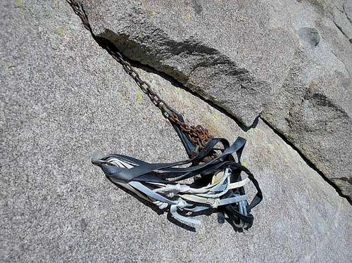
![Rappel anchors on Sugarloaf]() Here's what the anchors looked like before we replaced some of the slings
Here's what the anchors looked like before we replaced some of the slings
We had my older 50m rope and I had a couple prusiks just in case the rappel didn’t lead us to the appropriate location. So I started the descent slowly and about ¾ of the way down the rope it became pretty obvious that our rope was not going to be long enough to reach the next set of anchors (wherever they were located). However, our rope was long enough to reach a small ledge, and I figured I could rig an anchor there (leaving some gear) and we could continue our descent. I descended over the final lip and with a couple inches to spare my toes touched down on the small ledge. I quickly found placements for a few decent nuts and setup a three point anchor that I could clip into.
![Sugarloaf Rappel Route on the east face]() We were about 60' up this face and the anchors were about 50' up
We were about 60' up this face and the anchors were about 50' up
I yelled up to Brian to come on down and join the fun. (At this point Brian had no idea what he was rappelling into!). As Brian started his rap, I noticed another set of anchors about 30’ away down and to the descender’s right. My rope would not have reached those bolts, but a sketchy downclimb could get us there. As Brian approached my small ledge I let him know to be very careful coming over the final lip because he only had about four inches of rope to spare. He responded with a quizzical look and an expletive or two.
Once Brian reached my airy perch he belayed me down to the lower anchors and before we knew it we were back to the starting point of our roped climbing. With two 60m ropes one could rappel from the top anchors all the way to the saddle. Even with one 60m rope I think you could reach the intermediate anchors without having to unexpectedly reach the end of your rap rope.
For our descent we decided to take the gully abutting the east side of Sugarloaf and we ended up making 4 or 5 rappels off of well-slung trees. The first rappel leaves from a large Ponderosa pine tree that can’t be missed about 100 yards from the weakness that we ascended. Subsequent rappel anchors can be found just when the going starts to look pretty tough. At the end of our last rappel we weren’t too far above our stash of gear and we hightailed it down to the extra water in the dieing light of the evening.
![Sugarloaf on the Approach]() Looking back at Sugarloaf as the light faded on us
Looking back at Sugarloaf as the light faded on us
The remaining hike was slow, tedious, and sometimes damaging to my shins as we ended up in the dark for about 2hrs of off trail hiking before reaching the wonderful, wonderful trail. By the time we arrived back at the truck the climb had taken us 14hrs. It was a long day! What I did not know prior to the climb was that of the three other parties that Brian and I knew that had climbed the peak, two of them had spent the night on the mountain. When we finally arrived back at my house for the gear sorting, the Eagle Rare Bourbon and Johnny Walker Gold tasted awfully good going down.


Comments
Post a Comment