
-
 33267 Hits
-
 83.1% Score
-
 16 Votes
|
|
Area/Range |
|---|---|
|
|
31.90270°N / 106.49378°W |
|
|
Hiking, Sport Climbing, Toprope, Scrambling |
|
|
Spring, Summer, Fall, Winter |
|
|
7192 ft / 2192 m |
|
|
Overview
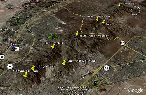
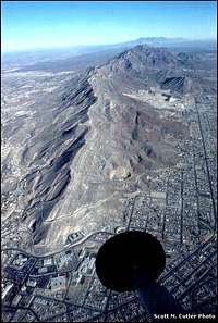
The Franklin Mountains are located primarily in far west Texas but extend into southern New Mexico. The range is approximately 23 miles long and 3 miles wide.
The mountains rise 3,400' above the surrounding city of El Paso. The highest peak is North Franklin Mountain which stands 7,191 feet above sea level.
The continuous north-south ridge line of the Franklin Mountains is separated by Anthonys Gap just north of the New Mexico state line.
The Organ Mountains to the north are separated from the the Franklin Mountains by the 4.5 mile Fillmore Pass.
The Franklin Mountains are named after Benjamin Franklin Coons who, in the 1850's, owned much of the land that is now known as El Paso.
The East and West sides of El Paso are separated by the Franklin Mountains. There are only two main ways to get from one side to the other, I-10 with runs south of the mountain range and Trans-Mountain Road (Loop 375) which runs through the mountains, between North and South Franklin.
The Franklin Mountains State Park encompasses most of the Franklin Mountains and comprises the largest urban park in the United States.
The Franklin Mountains were home to the only tin mining, milling, and smelting operation ever in the United States. The operation was active from 1910-1915.
Named Peaks and Canyons
The major, named peaks of the Franklin Mountains from north to south are:
 |
North Anthonys Nose | 5,388' |
 |
Anthonys Nose | 6,927' |
 |
Indian Peak | 6,544' |
 |
North Franklin Mountain | 7,192' |
 |
South Franklin Mountain | 6,791' |
 |
Mount Franklin | 6,135' |
 |
Sugarloaf Mountain | 5,226' |
 |
Ranger Peak | 5,632' |
 |
Comanche Peak | 5,225' |
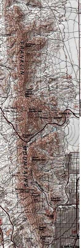
The major canyons of the range from north to south are:
Hitt Canyon (On the east side)
Vinton Canyon (On the west side)
Avispa Canyon (On the west side)
Fusselman Canyon (On the east side)
McKelligon Canyon (On the East Side)
The Franklin Mountains State Park
The Franklin Mountains State Park in El Paso, Texas is the largest urban park in the United States. It is comprised of 24,247 acres covering 37 square miles all within the city limits of El Paso.
The Park was created in 1979 by an Act of the Texas State Legislature. In 1981 the park was acquired by the Texas Parks and Wildlife Department and in 1987 it was opened to the public.
There is a fee of $4.00 for persons 13 and over to enter the park. Children 12 and under are free. There is a special group school-sponsored fee of $1.00 per person although you must contact the park to make arrangements. Holders of a Texas State Park Pass enter for free.
The Park is open from 8:00 a.m. until 5:00 p.m. most of the year. During the summer the park has extended hours and is open until 8:00 p.m. There is an additional $8.00 fee per site to camp.
Hiking in the Franklin Mountains

Aztec Caves
From Smugglers Pass off of Trans-Mountain Road (Loop 375):
The Ron Coleman Trail - A 3.8 mile one way, park maintained trail, which leads south from Trans-Mountain Rd, up to Elephant Rock, over South Franklin Mountain and down into McKelligon Canyon. The trail can also be hiked in reverse by starting in McKelligon Canyon.

West Cottonwood Spring
From the Tom Mays Unit:
Aztec Caves - A 1.5 mile round trip, steep trail leads up to the Aztec Caves.
West Cottonwood Spring - A steep 1.75 mile trail lead to the spring which has enough water to support on cottonwood tree. There is a bench under the tree making it ideal for a quick snack.
Mundys Gap - A well maintained, 3.5 mile round trip, trail up to the saddle allowing an unobstructed view of the northeast and east sides of El Paso. Continue on the trail past Mundys Gap to reach North Franklin Mountain, Indian Peak, and the Tin Mines.
From McKelligon Canyon:
The Ron Coleman Trail - The 3.8 mile one way trek starts at the end of McKelligon Canyon, traverses South Franklin Mountain, and ends on Trans-Mountain Rd.
Sugarloaf Mountain - From the intersection of McKelligon Canyon Road and Davis Seamon Road, at the enterance to McKelligon Canyon, a short bushwhack leads to the top of Sugarloaf Mountain.
From the end of Stanton St on the west side of El Paso:
Thousand Steps Trail - A 4 mile round trip hike which leads up to Ranger Peak, the Wyler Aerial Tramway, and a B-36 crash site.
Rock climbing and mountain biking in the Franklin Mountains
Rock Climbing

Sneed's Cory
Tom Mays Unit:
Sneed's Cory: 22 top rope routes ranging from 5.6-5.12.
McKelligon Canyon:
Flower Power Ledge: 10 top rope routes ranging from 5.7-5.13a.
Picnic Rock: A 5.10 top rope.
Peacepipe Arroyo: 7 top rope and trad routes ranging from 5.7-5.10 and up to 100 foot climbs.
Mountain biking

Mountain biking
Lower Sunset Trail: A 15.5 mile trail with many shortcuts which make shorter loops. The trail starts near the entrance to the Tom Mays Unit off to the left.
There are many other Mountain bike trail in the Franklin Mountains outside of the state park. The best source for information on bike trails is one of the local bike shops such as Crazy Cat Cyclery.
Camping and other activities in the Franklin Mountains
Camping
At the Tom Mays Unit there are 5 primitive sites and 5 sites for RV's (No water of electric hookups). There are no ground fires allowed within the park and there is no water available. There is an additional $8.00 fee per site to camp.
Other Activities

The Wtler Aerial Tramway on Ranger Peak is the only publicly accessible aerial tramway in the State of Texas. Admission is $7.00 for adults and $4.00 for children 12 and under.
An Amphitheater at McKelligon Canyon has performances during the summer. Upcoming events can be viewed at Ticket Master.
There are 2 gift shops in the Franklin Mountains, one on Ranger Peak and the other at McKelligon Canyon
When to enjoy
The Franklin Mountains can be enjoyed year round. El Paso has a semi-arid climate with very hot summers (with little or no humidity) and mild, dry winters.
Temperatures range from an average high of 55 F (13 °C) and an average low of 28 °F (-2 °C) in January to an average high of 97 °F (36 °C ) and an average low of 68 °F (20 °C) in August. The city's record high is 114 °F (45.5 °C), and its record low is -8 °F (-22 °C).
The sun shines 302 days per year on average in El Paso, 83 percent of daylight hours, according to the El Paso Weather Bureau. It is from this that the city is nicknamed, The Sun City.
Rainfall averages 8.74 inches (223 mm) per annum, most of which occurs during the summer from July through September. El Paso, at 3,800 feet elevation, is also capable of snow, but it is rare. The Franklin Mountains Wilderness Coalition In 1978, a year before the Franklin Mountains State Park was created, The Franklin Mountains Wilderness Coalition was formed. The Coalition is made up of organizations and individuals that, for the last 30 years, have worked to protect, preserve, and enlarge the State Park.
Currently the coalition is working to have the Castner Range added to the State park. They are also planning the 2009 Poppies Celebration, which should take place sometime in March.
You can find out more about the Franklin Mountains Wildlife Coalition including their history, upcoming events, next scheduled meeting, and more by visiting there website at www.iloveparks.com
External Links
Franklin Mountains on Wikipedia
Geological History of the Franklin Mountains from UTEP
Map of the Tom Mays Unit
Franklin Mountans State Park official website
Texas Parks and Wildlife Department
City of El Paso official website
VCRUX.com, the best source of information on rock climbing in the Franklin Mountains
The Franklin Mountains Wilderness Coalition