
-
 7151 Hits
-
 75.81% Score
-
 6 Votes
|
|
Route |
|---|---|
|
|
46.35925°N / 14.65714°E |
|
|
Mountaineering, Scrambling |
|
|
Summer, Fall |
|
|
Most of a day |
|
|
Walk-up |
|
|
Approach
Trailhead is at Roban's farm, 700 m. See the parent page!
Route Description
A decent macadam road goes through the beautiful valley till its end, to Robanova planina (Roban's pasture). This little less than 1 hour walk can be shortened by taking a mountain bike.
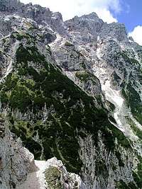
From the pasture you follow the marked path, which soon starts turning a bit towards the left, then crosses two ravines and finally reaches steep and rocky slopes of Velika Zelenica. In spring and early summer here's a snow field and a weak waterfall. From the waterfall the marked trail ascends steeper, allways keeping right of a big ravine. When reaching walls, it goes right again, well marked and protected. On our right we allways see Ojstrica's east face. Using a few narrow and exposed ledges as the most natural passages, ascending also directly upwards we, come over the rocky part in an hour. In next few minutes we reach over grassy slopes the saddle, cca 1750 m. Now we are on the northern edge of Dleskovška planota carst plateau. The terrain is covered with pine-tree bushes, peaks around us are not high, partly grassy, partly rocky.
The marked path now leads us horizontally towards the west, soon we reach the Molička planina, where on the edge a small hut and chapel stand. This is the old Kocbek hut, now renewed and (probably?) opened during high season. From the left also a marked path from Dleskovška planota joins us. We don't need to go just to the hut, but proceed westwards (going to the hut and chapel means a few minutes detour, but it's worth seeing them). The path starts to ascend slowly again, leading us around the Mala Ojstrica summit (on our right). After some 15 minutes another marked path, arriving from our left joins us. We just proceed to Sedelce (saddle), 1900 m, where a nice view on Korošica meadow opens. Here from the main path a weak marked path deters towards the north. (Astually we could do a shortcut some 10 minutes earlier, crossing without path the SW slopes of Mala Ojstrica to reach the SE Ojstrica ridge.

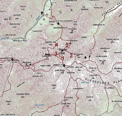
The path ascends towards the Ojstrica SE ridge. But instead of going steeply up (you can still do it), it goes far to the right, thus reaching the SE ridge very close to the summit of Mala Ojstrica. From there on, we just follow the SE ridge to the top. In the lower part, the path is clearly seen (it stays always marked), later it becomes weak and we must take some care not to lose it. On our left we see the Korošica Meadow and the markant summit of Dedec above it, on our right we look some more than 1000 meters down to Robanov kot. Higher on the ridge we pass by a natural rock window. Some 100 meters below the summit, rocks get steep enough to require some easy climbing, on the most exposed places the route is also protected. But in good conditions there are no real problems. After some 5 hours we reach the summit.
We can descend by the same route or, easier, by the South route, which leads us to Korošica hut (1808 m), from where we must do a 100 m ascent to Sedelce (1900 m) again. If we want to descend to Robanov kot, there are no other good options to choose, our path uses the only natural passage. All other trials would mean severe problems with orientation and climbing over the unknown, steep terrain.
 |
 |
 |
Essential Gear
Good shoes, poles. In summer no water on the route.