
|
|
Route |
|---|---|
|
|
36.39860°N / 50.96250°E |
|
|
Mountaineering |
|
|
Summer |
|
|
One to two days |
|
|
Hike and Scramble |
|
|
Getting There
From the shelter on the west end of the town of Roodbarak, drive a dirt road to a place called Vandar Bon. You will find another shelter at this spot. The road continues a little more to end at an elevation of 2350 m. Total distance from Roodbarak shelter to the end of the road is 12 Km.Route Description
All distances are per my GPSPlace………..…Elevation (m)…….Distance (Km)
End of Road……2350……………..Zero
Keshti Sang ……2700………………2.6
Rock
Sarchal Shelter….3750………………3.4
North Siah
Gook…………….4505………………2.0
South Siah
Gook……………4510……………….0.5
Total………………………………………….8.5 Km
From the end of the road, follow a well-established and well-signed trail to Sarchal Shelter/Alam Kooh (ie follow the left branch and not the right branch which goes to Kaljaran Pass/Kalahoo. Signs are in Farsi and in English). As the trail goes up the slopes, it generally remains about 100 m above the stream at the bottom of the valley. At an elevation of 2700 m, the trail crosses the stream near a huge boulder named Kashti Sang (Ship Rock).
At around 3450 m, you will see a huge hill made of dirt and crushed rock. This is probably the terminal moraine of the valley glaciers. Continue up the trail to reach the 3750 m Sarchal Shelter.
From Sarchal Shelter, head east and go up the steep slopes behind the shelter until you reach the saddle between Sar Espad Peak to the northeast and a Round-Top high point to the southwest. Turn southwest and follow the ridge-top to reach the summit of the Round-Top high point where a “plateau” appears. You can then follow any path to reach the summit of North Siah Gook Peak.
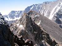
You can see South Siah Gook from North Siah Gook. A few jagged rocky high points stand between the two peaks. Descend a few tens of vertical meters on the west side of North Siah Gook and head south bypassing the jagged high points to the west of them until you reach the scree covered western slopes of South Siah Gook then head up to reach the summit.
 Western Slopes