
|
|
Mountain/Rock |
|---|---|
|
|
36.39860°N / 50.96250°E |
|
|
Mountaineering |
|
|
Summer |
|
|
14797 ft / 4510 m |
|
|
Overview
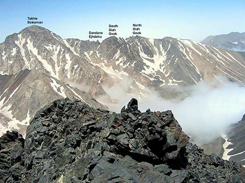
Click for Introduction to Central Alborz Mountains.Click to see the Map of the Takhte Soleyman Massif.
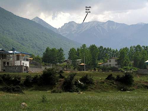
 South Siah Gook
In the central portion of the Takhte Soleyman Massif, between the Takhte Soleyman and Rostam Nisht Peaks you will find a jagged 1.5 Km long ridgeline that gives rise to many rocky high points. Detailed topographic information about this ridgeline is non existent. All of the topographic maps that I have ever seen depict the ridgeline as having a smooth top and give no information about the many ups and downs on the crest of this ridgeline. Three of the most prominent high points on the ridgeline have nevertheless been given names and other sources have provided approximate elevations for them North to south, these three points are as follows (the elevations of the first two points are per my GPS measurements):
1) North Siah Gook Peak 4505 m
2) South Siah Gook Peak 4510 m
3) Dandane Ejhdeha (Dragon’s Tooth) approx 4400 m
 Summit Summit | 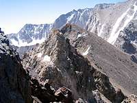 Summit Summit |  Summit Summit |
South Siah Gook is the most prominent of the mentioned high points. Its summit is made of a huge rocky block that is well-visible from most angles. The eastern slopes of South Siah Gook are wall-like and drop down into the tail end of the valley of Alam Chal Glacier near the Sarchal Shelter. A couple of horns stand below the summit of South Siah gook on the east side below its summit.
 Horns Horns | 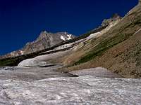 Horns Horns |
To the north, South Siah Gook is connected to North Siah Gook Peak via a number of jagged crags. The western slopes of South Siah Gook are steep scree slopes that go down to the bottom of the stream that drains the valley of Haft Khan Glacier. To the south, South Siah Gook is connected to a series of rocky towers that form a ridgeline which eventually merges into the northern slops of the Takhte Soleyman Peak. The most prominent of these towers is known as “Dandane Ejhdeha (Dragon’s Tooth).
 Haft Khan Haft Khan | 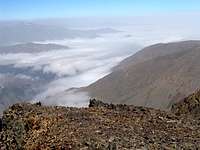 Siyalan/Sehezar Siyalan/Sehezar |  Chaloon/Siah Kamaan Chaloon/Siah Kamaan | 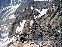 Steep Steep |
Despite its intimidating looks, thanks to its western slopes, South Siah Gook Peak can be climbed via a non-technical route. From the village of Vandar Bon (2350 m) you will hike to the Sarchal Shelter (3750 m) and then go to the summit of North Siah Gook Peak where you can gain access to the western slopes of South Siah Gook (see Route for more details).
 South Siah Gook
Getting There
 West Face, Photo by FereidounForghani
From downtown Tehran drive 40 km west to the town of Karaj and take the Karaj-Chalus Road north (This road crosses the Alborz Mountains taking you through the Kandovan Tunnel to the Caspian Coast). 30 km south of Chalus, you will reach the town of Marzan Abad. Turn left and follow a side road into the Sardab Rood River drainage and to the town of Roodbarak. Distance from Tehran to Roodbarak is roughly 200 km.
Red Tape
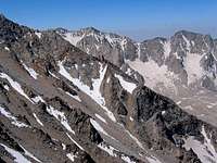
 (R) South Siah Gook, (middle) Takhte Soleyman Peak
Non-Iranian citizens will be charged a fee of around $50 in the town of Roodbarak.
Camping
 From Roodbarak Village
Anywhere.
External Links
 From the summit of Chaloon Peak
Add External Links text here.