
-
 8666 Hits
-
 74.01% Score
-
 4 Votes
|
|
Route |
|---|---|
|
|
36.37680°N / 50.96190°E |
|
|
technical rock climb |
|
|
A long day |
|
|
5.9 high altitude |
|
|
Approach
The quickest and most convenient way is to use a van from Rudbarak, then Federation Camp site and Akapol at 1900 meters. The dirty road goes to the southwest in a very deep valley, you'll see another dirty road going to the south just before a big shelter (still under construction during summer 2005) at about 2300 meters. Stay on the same road, the other one leads to the start of Alam kuh normal route.
From the top of the driveable road, a little bit after Vandar Bone at 2500 meters, take the trail on the right side of the valley (in orographic meaning), cross some steep avalanche couloirs and a bridge at about 2800 meters. Then stay on the left side of the valley, you'll see a flag at 3000 m and reach the Sarchal shelter at 3700 meters (wrongly indicated at 3850 meters for some maps)
From Sarchal shelter take the Alam glacier valley to the south, go straight ahead up to 4000 m, then turn right up to the destroyed shelter at 4100 m. From the building only remain some parts of the walls. From the shelter goto a pass at 4300 m at the beginning of the north ridge, which leads to the
top of Alam Kuh at 4850 m. Be careful between the destroyed shelter and the pass because of the avalanche danger, even during summer after snowfalls.
 |  |  |  |  |
Route Description
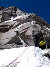
From the pass follow the ridge up to 4500 meters, it's sometimes necessary to leave the edge of the ridge in order to avoid difficult steps. Some equipments (scales...) hae been installed for difficult steps, so that the route isn't more difficult than 5.8+ with (normal conditions). The route can be much more difficult in winter conditions.
At about 4500 meters cross the north face to the right, then climb a corridor up to the summit.
I think the easiest way to stay on the right route is to look at the
equipments installed on the rocks and at the clues of human passage...
 |  |  |  |  |
Essential Gear
Classical climbing equipment, most of the route is already equipped with spits.
Don't forget the helmet because of the numerous rock falls.
On late spring and early summer snow/ice gear (ice axe, crampons...) due to the heavy snowcover. In early june 2005 the whole route was still in winter conditions, cracks were full of snow and the ridge was terribly windy, which prevented us from reaching the summit.
Miscellaneous Info
If you have information about this route that doesn't pertain to any of the other sections, please add it here.
 |
Casas - Aug 10, 2016 1:30 am - Hasn't voted
DescentNobody talks about the decent of Alam kooh back to Sarchal glacier and it's tricky. Notice that you see the las part of the descent from the base camp, to the left of the north wall, in the cha-lon pass. You have to go there after climbing and unclimbing siya-h sang. On the lower part of the path once in the sarchal slopes there is some snow but soft enough to surf it with boots and not too steep. If you plan to do that in esrly earlymorning/night, snow will be harder... You arribe on the summit after climbing the german ridge and you find all the teams that walk through the south slopes from hesarchal. You have to follow the path to hesarchal for some minutes until you arrive close to the long ridge that this path follows (east). Here you take the well traced path to the left instead of continuing going down with the rest of the teams. From one of this passes you will see the siya-h sang hut (red). I think you can also turn left in other passes but this first has some cans and is the one we used. After this first turn you continue going down north east and you can see a good path that follows next to a little wall but to arrive there you have to unclimb and descent through very vad rock little cliffs. It was free of snow for us. Then you have a good path and you are in the red hut after going up for some minutes. If you climbed a hard route in the north face you will probably sleep here as the next section is dangerous due to bad rock, and you don't want to do it at night. Unless you are very fast climbers and you arribe here with enough light. Climbers of the ridge usually have time enough to skip the romantic sleep in the dirty hut without glass windows (heaps of rocks cover the empty space) Now you have to cross siya-h sang summit climbing up and down following cans. Easy. When you arrive in a big pass, be carefull not to turn down left through some steep rocky slopes as you will end up in the middle of nowhere. Very dangerous, we found some people lost there and we told them to come back to the path. When you are near the top, you can see the disposition of the ridge you are following and the valleys it splits. You have to go to the left towards the north, north east. You will, at some point, distinguish, very far, the path that goes down from tha cha-lon pass to sarchal and base camp. When you start descending siya-h sang you find the famous cables recently changed (august 2016). At some point you have to follow the old wires as the new ones are thought for winter and they hung in the air impossible to follow them. The rock is extremely awfull all the time. We found mountaineers without helmet, crazy idea. After this unclimbing you reach the cha-lon pass. Now it's done, you just have to follow the path that leads to the last slope of the pass (the first ones have more snow and are steeper) and surf the rock first and snow after to finally reach the base of the glacier. Cross it where you better like it and you are in the base camp again. This descent is the same or similar for the rest of the routes in the north face. Schedule for us: 4h 15m for the german route, 15m to the summit and 3h 30m for the descent. Have fun.