
-
 12662 Hits
-
 81.18% Score
-
 13 Votes
|
|
Route |
|---|---|
|
|
51.20344°N / 116.39671°W |
|
|
Mountaineering |
|
|
Summer |
|
|
A few days |
|
|
5.4 (YDS) |
|
|
IV |
|
|
Overview/Approach
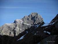
The “Goodsirs”, as this cluster of peaks is more commonly referred to, include North and South Goodsir Towers along with a sub-peak (basically a col between them) named Middle Goodsir. The true Mount Goodsir summit sits at the South Tower at 11,686’. This is an elusive and less commonly achieved group of the 11,000er’s in the Canadian Rockies. Even though Bill Corbett’s book (The 11,000er’s of the Canadian Rockies) has set off a local group of peak baggers intent on summiting all the 11,000’+ objectives (54) in the Canadian Rockies, those who have gotten to these three summits on one push are few.


Of my dozen or so seasons in the Canadian Rockies mixing technical rock and ice skills with a fitness regimen of mountaineering and scrambles and recording several speed ascents along the way via solo trips, I found this particular solo jaunt up the Goodsirs perhaps the most taxing of all, both mentally and physically. Conceivably it is my age (49) and/or possibly because I missed Corbett’s approach notes where he references an option of runners and shorts for the deep marsh approach. The direct trek through the marsh is how I recommend tackling the approach from the warden cabin (locked-2012) to Zinc Creek.
Relying on the “Book of Lies” (Selected Alpine Climbs in the Canadian Rockies) and errant beta from Peakbagger.com, I constantly thrashed from river bottom to several hundred feet above and back down again trying to find a referenced path through the deadfall and alders on the right bank of the Ice River, to no avail. If there ever was a path above the Ice River, it is no more. On return, I headed down to the marshy bog from Zinc Creek and waded back to the cabin in waterlogged boots.
Even avoiding the pitfalls I faced on approach, to do a zig zagged traverse of all three 11,000’+ peaks that make up the Goodsirs in three days involves a serious elevation gain (fitness) objective. The Ice River trail starts at approximately 4000’ and the South Goodsir Tower sits at 11,686’. Estimating the North Tower bivy at approximately 7000’ and the North Tower and Middle Goodsir col at approximately 9000’, your total elevation gain over three days is going to be approximately 13,000’ to 14,000’, steering this trip into the alpine IV grade realm. The rock climbing on both towers is published at 5.4 and I did not experience any ground any more difficult than that. I highly advise groups to not exceed two and definitely keep climbing teams down to one per tower on any given day. There is so much loose ground to cover, the rock fall was unnerving even though solo.
The approach is full of typical British Columbia dead fall and foliage (even to the Warden Cabin in 2012), the rock on the two towers is horrible (the worst I have seen) and the mosquitos can be unrelenting even as late as September. Yet the solitude of being the only human (saw moose and bear) back in this deep rooted valley on the edge of Yoho National Park can have its reward. Part of the suffrage can be alleviated in where and how you bivy, if your intent is to summit all three peaks.
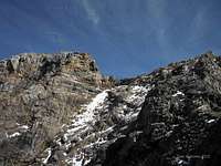
I chose the SW ridge ascent of the South Tower. There is a snow field that leads to a SW face option noted somewhere out there as a possible, more direct, route. I cannot advise anyone to ever ascend, or descend for that matter, this snowfield from the rock fall I witnessed coming down from the loose and fractured face above. I doubt if anyone actually has. The whole time I was cursing the rock on the ridge in general. I was curious what possibly prompted Cheesmond and Doyle to put up an Alpine VI route (1983) on the north face of the South Tower. The North Tower has just one route established as of 2012, the southwest face up the infamous sideways “V” which is by far the most interesting feature on either mountain. The Middle Goodsir is nothing more than a short scramble several thousand feet from the base of its col with the North Tower.
A trip report on-line at PeakBagger.com has hideous beta regarding the drive and approach. Corbett’s approach beta is much more accurate, unfortunately I did not have his beta with me on my trip. Reading it after the fact, his mile markers regarding the road are spot on. From Field, continue until you just leave the Yoho National Park. There is an on-off ramp about 1km to the west of the park that is marked as Beaverfoot Road. Beaverfoot Road is an active logging road that also services a resort lodge about 10kms in called Beaverfoot Lodge (cool place, hospitable manager-Raff as of 2012, check it out on return). This logging road is well maintained and plenty wide for two way traffic. At 19.4kms (no road sign, but a km sign) is a dirt road on the left named Ice Main Road. Turn left onto this road and either park at 3.5kms in the first clearing you come to or follow Corbett’s directions which might get you 5-10 minutes closer.
At the first clearing, an ATV club/concessionaire maintains (2012) an ATV sized road that connects into a logging road in approximately 15 minutes by foot. Hop on this logging road and follow it left to a large clear cut area where the North Goodsir Tower is in clear view in the far distance. Look for a well flagged trail (2012) on the left that descends the clear cut down to the signed (2012) Ice River trail, then turn right and follow this trail (full of deadfall and washed out in several locations in 2012) to the Warden Cabin. The erroneous Peak Bagger beta says 1-2 hours. Corbett says 2-3 hours. I am known to be fast, but with the deadfall issue and washouts it took a full 2 hours each way to the seldom used Warden Cabin.
Route Description
During a 50 hour period involving two complete and well rested bivies, I made the arduous approach up Ice River and Zinc Creek, ascended from below Sentry Peak and Zinc Mountain up the furthest south “southwest ridge” leading up to the South Goodsir Tower’s summit and returned back down the ridge, traversed to the west and ascended the south face of the North Goodsir Tower, then back down to its col with the Middle Goodsir and finished up via a scramble to its summit and return to the vehicle.Once at the warden cabin (not used or inhabited during 2012), remove pants you want to keep dry and don trail running shoes (will lose sandals in the mud) and just commit 100% to the Ice River Valley. This marsh is unique in that there is no consistent solid ground to follow between the very edge of the dreadful deadfall and alder laden forest and the wide expansive marsh river bottom. You need to commit to one or the other. I advise you push on out into the marsh proper a bit and then make a beeline northeast through shallow and sometimes deep water. If you commit to the marsh this way, I predict you will be at a flagged (2012) trail heading up the hill to angle into Zinc Creek within an hour. You do not want to wait for the actual meeting of Zinc Creek with the Ice River as the alders are too thick at this juncture. Instead, as the North Tower really comes into view and you can see that Zinc Creek might be over the next hump on the slopes to the right, start looking for a flagged trail (2012) that meanders up an avalanche clearing of sorts, not a large one. The trail is not well flagged and hard to make out. If you lose it, just remember, you are trying to angle up and left avoiding the alders and entering the forest along Zinc Creek. There are options if you get lost, bottom line, aim for the trees on your left and then keep moving left to Zinc Creek until you locate a distinguishable trail (2012) on its right bank.
The trail forks down left at a point as you are ascending Zinc Creek. This left fork takes you down to the creek so you can cross it, gain the trees on the right side of the drainage on the opposing slope (alders) and head for the traditional bivy below North Tower. However, my choice for doing both of these objectives (North and South Towers) together, yielding me a much better bivy and start for the South Tower on day two, was bypassing this Zinc Creek crossing and continuing up Zinc Creek trail until you hit significant fresh avalanche debris (2012). Pick your way through to the other side of the debris and exit the forest up onto a small rocky drainage (start of Zinc Creek) coming down from Sentry Peak, Zinc Mountain and South Goodsir Tower.
Head up this drainage for Sentry Peak and as it comes into view (a sentry looking tower on its summit), look for a cleared drainage slope on your left that is void of alders or trees. After ascending this grassy/rocky slope, traverse back left over at least one drainage (but full of alders down below) and ascend this pleasant slope up to a beautiful grassy boulder outcrop area that had an active drainage to its right. Several large boulders situated just below this further south ridge of the southwest ridge(s) of South Tower make for a bivy worth inclusion in Corbett’s list “top bivy-camping sites”.
There are two lower southern ridges on the South Goodsir Tower and either can be ascended. They meet at a broad section in the ridgeline. The higher summit ridge consists of endless amounts of rotten limestone. At one point you must traverse a rock filled bowl far left to keep with the ridge proper, below an independent sub-face. Rock fall was an issue at this juncture in late August from a recent freeze-thaw cycle. This is a potentially dangerous traverse. I advise doing it low (cairn in 2012 to the ridge far to the left) or high, avoiding the middle. Most of the middle ground consists of ball bearing type scree slowing you down below the objective hazard of falling rock above.
You will encounter mid-5th class climbing in bits and spurts for the last several thousand feet gain up the southwest ridge of the South Goodsir Tower. As it curves left I encountered some verglass on the west facing aspects of the ridge. It did not slow me down much because I was already moving at a snail’s pace due the poor nature of the rock. Tons of exposure and atrocious loose blocks litter the ridge as it continues to curve left at several junctures creating a few false summits. The final head wall has the most sustained 5th class section up and left to the true summit. On return I cleaned up three fresh rap slings near the summit, therefore South Goodsir Tower appeared to have seen at least one other ascent in 2012 or 2011. I free soloed the entire ridge without a rope and had no more worries down climbing any of the loose blocks and steps than I did climbing them.
On descent, I met back up with my backpack (tent, etc) I left along the ridge I ascended (important to pay attention and descend the proper ridge after they split if you need to regain gear, skiers left in this case). I then easily traversed to the right to the next southwest ridge line. I followed it down to where it met tree line (established bivy site, no water) and descended loose shale down to the drainage of the Middle Goodsir where I made my next bivy. Older beta referred to a higher bivy up and left on the last patch of grassy ground found below the North Goodsir Tower but no running snow melt was available in late August, thus I chose a bivy down by the drainage proper.
I chose to get an early start from this bivy location based on rock fall I witnessed the previous day. You can easily make your way up the right option, of two snow slopes above, in the dark. The left has much more rock fall hazard. Once level with the obvious sideways “V” ramp, traverse into it and follow it left then back right. In late August, 2012, the V (photo) had just the right amount of snow and scree to navigate quickly. The exit of the ramp is the crux of this route, but the rock was much more solid than anything on the South Goodsir Tower’s ridge. Once you exit the “V”, the summit of the North Tower is just a short distance by scramble. The climb and return of the North Tower took me half the time of the South Tower (not including the jaunt to the Middle Goodsir).
The Middle Goodsir is really not a mountain or tower, but I will play along since Corbett has it officially listed as one of the 54- 11,000’+ summits. The return to the bivy is quick and easy from the summit of the Middle Goodsir.
Descent
The return is not very pleasant down to Zinc Creek from the bivy below the North Goodsir Tower. Although from above the descent below looked all grassy and soft, in reality it is full of large scree covered with loose vegetation. The mosquitoes in late August were in full swarm (unusual in the Canadian Rockies this time of year) when I reached the top of the waterfall that feeds Zinc Creek. To avoid the mature alders (which is a must) at the top of this waterfall, angle left through a break in the alders to the forest. Travel far enough left through the trees to avoid descending into more alders and avalanche debris. Descend down to Zinc Creek which is fairly easy to cross due to so much deadfall. Ascend the opposite bank and don’t despair, the Zinc Creek Trail will show up eventually even though it is a short, but thick, bushwhack to reach it. Turn right on the trail and pay attention to the flagging (2012) and you will find your way back down to the Ice River valley without too many alders and deadfall in your way.If you took running shoes as I advise, take your boots off (will have to cross many waist high sections) and head out away from the hillside and just pretend you are hunting gators in the Everglades as you meander back west through the thick bog. When you reach a huge log jam where the valley starts to narrow, gain the left side of the marsh and attempt to locate a faint trail back to the warden’s cabin and Ice River trail.
Essential Gear
I soloed all three peaks which included down climbing, thus no rope. To each his own, but a 30m alpine rope should cover you. Obviously bivy gear is in order. Plenty of water opportunities to the southwest ridge of the South Tower and before heading up the north face of the North Tower. Highly recommend two poles to help with such a long trek including the long marsh slog. Most important recommendation is to take shorts and runners to use for the marsh, just leave them on the bank when you start up towards Zinc Creek. I retrieved several rap slings off of the west ridge of the South Tower. If you intend on needing to rap, bring plenty of tat. Expect verglass on both peaks. Unusual late mosquito presence, heavy in the valley directly below the North Tower. One of the thickest bushwhacks in the Canadian Rockies, do not take your favorite clothes. I saw bear and moose in late August, follow whatever your normal protocol is regarding same.External Links
100’s of Canmore and Banff National Park multi-pitch rock climbs, ice climbs, alpine climbs and scrambles, just scroll down to routesYoho National Park, Parks Canada
Best Climbers Hangout: Summit Café, most likely place to find me in season or my brethren shooting the bull about beta. Best “large” breakfast in town, good coffee as well, serve Mennonite meats from Valbella, which is the best place to buy free range products anywhere in the world, right here in Canmore.