
-
 9268 Hits
-
 71.06% Score
-
 1 Votes
|
|
Route |
|---|---|
|
|
40.71110°N / 110.8228°W |
|
|
Scramble with Exposure |
|
|
Half a day |
|
|
Class 3 - 4 |
|
|
Approach
See getting there (Hayden Pass ~ Highline Trail)
Route Description
6.81 miles round trip
3,300’ of elevation gain
Trailhead elevation = 10,370’
Summit Elevation 12,428
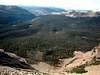
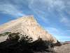
Do not take the Highline Trail; the route leads along the backbone of a ridge leading directly from the parking area east to the ridgeline. The route starts out with a gently grade and soon picks up while climbing through several small cliff bands. Only one area before hitting the upper (north south running) ridgeline requires some serous negotiating, this is about a 15’ ledge band scramble-climb. The ridgeline is about 1 mile and elevation 11,720 from the trailhead. Follow the ridgeline with its few undulations (see photos for the ridgeline) for another mile to the saddle below Mt. Agazzis (route coming in from Ryder Lake). An easier route would be to follow the contours on the west around the base of the few peaks of the ridgeline. One of the peaks offers a great view and a little vertigo when getting close for a good picture. From the Saddle the peak is another 0.75 mile and 1,000’ of vertical, no real trail exists so look for the path of least resistance.
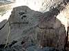
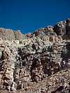
After reaching the summit you can either return via the approach or try a loop route via Highline trail. The route to Highline does not have any trail markings of any kind and requires some dicey down climbing through a natural drainage. After leaving the summit, heading in south direction the ridge to Ram Peak (11,641’) will come into view. Stay heading in a southwest direction down a drainage towards an amphitheater. Start getting some bearings for the travel through the forested area; I used Mt. Baldy as a point of reference. After about 0.5 mile some water falls (if water was present) is were some class 3-4 down climbing comes into play. After negotiating the cliff bands start heading down the natural drainage while heading towards Baldy (as reference). After 1.3 miles of cross-country bushwhacking an old trail is encountered. Follow this west until it intersects the Highline Trail just southeast of Scudder Lake. From here the route back to the trailhead is very straightforward.
 |  |  |  |  |
Essential Gear
No technical gear is required in the summer months. If attempting this in the winter, which SR 150 is closed due to snow, basic snow travel gear, crampons, ice axe would be recommended.
Miscellaneous Info
If you have information about this route that doesn't pertain to any of the other sections, please add it here.