
|
|
Route |
|---|---|
|
|
47.51910°N / 13.35520°E |
|
|
Hike, Ski-Tour |
|
|
Most of a day |
|
|
Walk-up |
|
|
Approach
Lungoetz may be reached by public bussesBy car:
from the north: leave the motorway A10 at Golling and follow the main road to Abtenau
from the south as well as from the north: leave the motorway A10 at the exit Hüttau, Lammertal and follow the main road via St. Martin to Lungoetz
at Lungoetz branch off to the West into the uppermost Lammer valley. Start your ascent at the small t-bar lift.
 |
Route Description
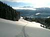
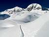
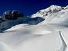
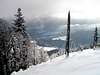
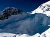
When climbing Hochkarfelderkopf with by ski you can shorten the ascent by using the drag lift. At the top of the lift you have to look for the ski track that usually runs up on the ridge between Labachrinne and Passruckgraben. Beautiful woods are crossed till a height of approximately 1600m a.s.l. Here only dwarf-pines can exist. At a height of about 1900m a.s.l. a small but impressive plateau, confined by steep walls, is entered. At the western end of the plateau a steep slope leads to the summit ridge of Hochkarflderkopf.This last slope might be dangerous if snow conditions aren´t stable.
Depending on snow conditions and whether there is a track or not the ascent may take 3 to 4 hours.
 |  |  |  |  |
More Photos From The Route
 |  |  |  |
Essential Gear
No special gear is needed.Best time for skiing is from December to April. For non-skiers autumn is most favourable.
 |