
-
 9662 Hits
-
 79.78% Score
-
 11 Votes
|
|
Route |
|---|---|
|
|
34.09306°N / 118.60972°W |
|
|
Download GPX » View Route on Map |
|
|
Hiking |
|
|
Spring |
|
|
Half a day |
|
|
trail |
|
|
Overview
Hondo Canyon is a lovely, small canyon to the west of the much larger Topanga Canyon in the Santa Monica Mountains of Southern California and part of Topanga State Park. The overall stats of about 3.5 miles one way with about 1,600 feet of elevation gain seem to prevent most city dwellers and occasional outdoor walkers from hiking the canyon. You will most likely not encounter too many people on the trail, much fewer for sure than on most other trails in the Santa Monica Mountains. The trail is part of the Backbone trail system, which traverses the entire Santa Monica Mountains. You can hike the canyon from bottom to top or vice versa. There are trailheads on both sides that are accessible by car. Of course the most demanding and rewarding experience is to hike it up and down. From the top of Hondo Canyon there are plenty of opportunities to extend the hike even further, depending on one’s strength, ability, and of course time constraints. The first part of the trail (near the canyon bottom) is mostly in the sun, but the upper portions are nicely shaded under an oak and later chaparral forest.
|
|---|
Getting There
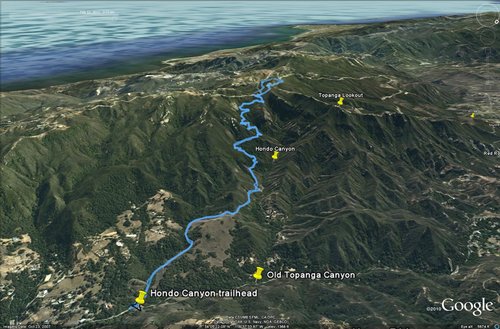
The trailhead is on the west side of Old Topanga Canyon Road 0.4 miles north of the intersection of Old Topanga Canyon Road and Topanga Boulevard. It is between Monte Vista and Hondo Canyon Road. There is a small turnout for some cars. The trailhead is not especially obvious and lies in a curve, so please drive carefully there. Park near the trailhead on the side of the road. There is a limited amount of parking. The trailhead sign reads “Backbone Trail” and there is no mention of Hondo Canyon there.
Route Description
From the trailhead at Old Topanga Canyon Road (791’), you walk down to a little stream, cross it, and begin your hike uphill first under the cover of majestic live oaks, later over sloping green meadows. The trail here is moderately steep and ascends a lesser, separate ravine. In a little less than a mile the trail turns west (1,190’) and enters the proper Hondo Canyon. Shortly, a little side trail leads you to a rocky point (1.1 miles, 1,190’), where you can see the entire Hondo Canyon and the stream tumbling through a little gorge below. This is an ideal spot to take a first rest and enjoy the surroundings.
| Rolling Hills | Rocky Perch |
|---|---|
 |
 |
From this point the trail switchbacks the south slope of Hondo Canyon through gnarled live oaks and further up under a tall chaparral forest. Along the way you will enjoy breathtaking views of sedimentary rock formations known as the Sespe Formation, which is a fossiliferous sedimentary geologic unit in southern and south central California. It is of non-marine origin, consisting predominantly of sandstones and conglomerates laid down in a riverine, shoreline, and floodplain environment between 40 and 24 million years ago (upper Eocene to the end of the Oligocene).
| Sandstone Cliffs | Hondo Canyon |
|---|---|
 |
 |
Along the trail under some majestic oak trees, you come across some ruins (concrete foundations, steps, gate). Those are the remains of two cabins, which belonged to the Bragg family. Paul C. Bragg is considered a pioneer of the Health Movement in the 20th Century. He died in 1976 at the age of 81. The cabins were eventually destroyed by the 1993 fire. Many wildflowers can be seen along the trail, including a vast number of Tree Poppies, Purple Nightshades, Milkmaids, Prickly Phlox, Wild Peas.
| Tree Poppies | Milkmaids |
|---|---|
 |
 |
After about 3.5 miles (2,330’) you top out on the Saddle Peak Road and sweeping views open up south over other parts of the Santa Monica Mountains with the Pacific Ocean behind. From this point after taking in the views you can retrace your steps and hike down the canyon for a total of about 7 miles and a little over 1,500 feet of elevation gain.
There are plenty of options for those who want to extend their hike from the top of Hondo Canyon. Shortly before reaching the Saddle Peak Road the Fossil Ridge Trail (trail sign) veers off and contours above the Saddle Peak Road around the west end of Topanga Ridge. On top of Topanga Ridge there are some towers, which were already visible for most of the hike up Hondo Canyon. You can scramble (steep and loose) directly from the Fossil Ridge Trail up to the towers (2,560’). One installment is obviously not functional and fenced off by barbed wire. That barbed wire does not seem to hold off everybody as judged by the many graffitis. A newer, functional tower installation is right next to it.
If you stay on the Fossil Ridge trail, you will come to the start of Topanga Tower Motorway at the intersection of three roads (Stunt Road, Schueren Road, and Saddle Peak Road). At that intersection is Lois Ewen Overlook, which is certainly very worthwhile for its sweeping views. From there you can cross Stunt Road and connect to another portion of the Backbone Trail that takes you to Saddle Peak. You can also stay on Topanga Tower Motorway and walk pretty much level for about 0.7 miles first on a paved road then on dirt to Topanga Overlook, the site of a former fire lookout.
| Saddle Peak | Topanga Ridge |
|---|---|
 |
 |