

-
 33085 Hits
-
 92.32% Score
-
 38 Votes
|
|
Area/Range |
|---|---|
|
|
34.08000°N / 118.72°W |
|
|
Hiking, Trad Climbing, Sport Climbing, Toprope, Bouldering, Aid Climbing, Scrambling |
|
|
Spring, Summer, Fall, Winter |
|
|
Overview
 Scott and Anya walking towards the Goat Buttes
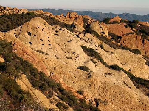
The Santa Monica coastal range extends some 40 miles (64 km) east to west from the Hollywood Hills in Los Angeles to Point Mugu in Ventura County. The mountains form a natural barrier between the San Fernando Valley and the Los Angeles Basin, separating "the Valley" on the north and west-central Los Angeles on the south. The Santa Monica Mountains run parallel to the Santa Susana Mountains, located directly north across the San Fernando Valley.
Geologists consider the northern Channel Islands to be a westward extension of the Santa Monicas into the Pacific Ocean. The range was created by repeated episodes of uplifting and submergence by the Raymond Fault that created complex layers of sedimentary rock. Volcanic instrusions have been exposed, including the poorly named Sandstone Peak, the highest in the range at 3,111 feet (948 m). Malibu Creek, which eroded its own channel while the mountains slowly tilted up, bisects the range.
The Santa Monica Mountains have dry, warm to humid summers and wet, mild to cool winters. In the summer, the climate is very dry, which makes the range prone to wildfires. Snow is very rare in the Santa Monicas, due to the mild Mediterranean climate and lower elevation.
The Santa Monica Mountains are in the California chaparral and woodlands ecoregion and are covered by hundreds of local plant species, some of which are very rare, and others of which have become popular ornamentals. The range is host to an immense variety of wildlife, from mountain lions to the endangered steelhead.
The mountains have more than 1,000 sites of archeological significance, remnants of the Tongva and Chumash people. Today, the Santa Monica Mountains face pressure from local populations, who see the range as a recreational retreat, a desirable residential area and as an increasingly rare wild place in urban Los Angeles.
Cahuenga Pass, present-day site of the U.S. Route 101, is the easiest pass through the range connecting the Los Angeles Basin to the San Fernando Valley. In the 1800s, two battles were fought there, and the Treaty of Cahuenga was signed nearby. In the heyday of Hollywood movie studios clustered on both sides of it. Sepulveda Pass is the main north-south pass to the west, connecting the Westside to Sherman Oaks via the San Diego (405) freeway. Further west are Topanga Canyon Boulevard, Malibu Canyon Road, and Kanan Dume Road. Mulholland Drive runs most of the length of the Santa Monica Mountains, from Cahuenga Pass to Sequit Point. The eastern end of the range, located in the City of Los Angeles, is more intensively developed than the western end of the range. The city of Malibu runs between the coast and the leading mountain ridge, from Topanga Canyon in the east to Leo Carrillo State Beach in the west. The term Malibu Ozarks is sometimes used derogatorily (or ironically) for the unincorporated part of Malibu beyond the leading mountain ridge and lacking an ocean view; the term is often used synonymously with "818 Malibu" (referring to the less desirable San Fernando Valley telephone area code prefix).
Much of the mountains are located within the Santa Monica Mountains National Recreation Area. Preservation of lands within the region are managed in part by the Santa Monica Mountains Conservancy. Over twenty individual state and municipal parks are in the Santa Monica Mountains, including: Topanga State Park, Leo Carrillo State Park, Malibu Creek State Park, Point Mugu State Park, Will Rogers State Historic Park, Point Dume State Beach, Griffith Park, Charmlee Wilderness Park, Runyon Canyon Park, and the Paramount Ranch.

Named Peaks
| Peak | Feet | Meters |
| Sandstone Peak | 3,111 | 984 |
| Tri-Peaks | 3,010 | 917 |
| Exchange Peak | 2,950 | 900 |
| Boney Peak | 2,825 | 861 |
| Castro Peak | 2,824 | 862 |
| Saddle Peak | 2,805 | 855 |
| Calabasas Peak | 2,165 | 660 |
| Temescal Peak | 2,126 | 648 |
| San Vicente Mountain* | 1,965 | 599 |
| Clarks Peak | 1,965 | 555 |
| Mesa Peak | 1,844 | 562 |
| Cahuenga Peak | 1,820 | 555 |
| Brents Mountain | 1,713 | 522 |
| Mount Lee** | 1,640 | 500 |
| Mount Hollywood | 1,626 | 496 |
| Mount Chapel | 1,622 | 494 |
| Mount Bell | 1,587 | 484 |
| La Jolla Peak | 1,567 | 478 |
| Laguna Peak | 1,457 | 444 |
| Mugu Peak*** | 1,266 | 386 |
* Former site of a Nike missile base. Now a Cold War Park.
** The Hollywood Sign is on the southern slope.
*** The westernmost in the range, it rises directly from the pounding surf of the Pacific.
Getting There
 Google Earth Image
The Santa Monica Mountains cover a large area north of Los Angeles along the coast. You can access the mountains via the Pacific Coast Highway (1), the Hollywood Freeway (101) or the 118. The southern Region (Griffith Park)can be acess via the I5 and 134 freeways.
Rock Climbing
 Climbing photo by MelbaToast
 Planet of the Apes Wall
The Santa Monica Mountains not only offer great hiking possiblities, but there is also some world class climbing as well. Some popular climbing spots are as follows:
Stoney Point
Malibu Creek State Park
Malibu Tunnels Boulders
Miniholland Boulders
Point Dume
Point Mugu Rock
Also, the Slab near Saddle Peak offers some great slab climbing, see photo.
Weather and External Links

Santa Monica Mountains National Recreation Area
Santa Monica Mountains Conservancy
Wildflowers of the Santa Monica Mountains
SMMNRA Interactive Locator Map
Google Map
Source
This material is from http://en.wikipedia.org/wiki/Santa_Monica_MountainsThe license Wikipedia uses grants free access to our content in the same sense as free software is licensed freely. This principle is known as copyleft. That is to say, Wikipedia content can be copied, modified, and redistributed so long as the new version grants the same freedoms to others and acknowledges the authors of the Wikipedia article used (a direct link back to the article satisfies our author credit requirement). Wikipedia articles therefore will remain free forever and can be used by anybody subject to certain restrictions, most of which serve to ensure that freedom. More Info.
Bob Burd - Dec 1, 2009 2:36 pm - Hasn't voted
westernmost peak"*** The westernmost in the range, it rises directly from the pounding surf of the Pacific." Actually, Laguna Peak is furthest west.