
-
 12507 Hits
-
 77.48% Score
-
 8 Votes
|
|
Route |
|---|---|
|
|
28.67997°N / 84.06153°E |
|
|
Hiking, Mountaineering |
|
|
Spring, Fall |
|
|
Most of a day |
|
|
easy hike |
|
|
Overview
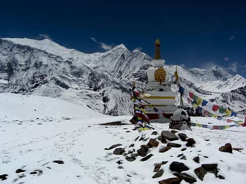 Stupa at Kicho Tal with Annapurna peaks
One of the acclimatization walks preparing you for the Thorong La traverse on Annapurna Circuit is the Ice Lakes Trail east of Manang.
Starting at the small village of Braga, alternatively at the even smaller village of Mugje, the Ice Lakes trail winds itself up the lower north slopes of Chulu East / Far East and ends at about 4650 m at the beautiful lakes, which are called Kicho Tal (Tal means lake) by the Nepali.
The lakes are embedded in two huge cirques which are bordered by several ridges coming down from Chulu East peak, separating the Chulu Khola with the Chulu East / Far East base camp to the east and the Ghatte Khola to the west.
East and north of Kicho Tal there are some unnamed peaks, 5155 m, 5035 m and 4989 m high, which do not, as far as I know, require an extra permit and can be climbed if you like so. The trail ends at the upper one of the two lakes and the continuing route to these peaks seems to be mainly off-trail. As there was fresh snow on our visit of the lakes in April, 2014, I cannot say how difficult the terrain is. It seemed to me that the 4989 m peak was the easiest to climb; the 5035 m peak has a rather rocky appearance and seemed to require a good climb at the end of the ascent.
 Annapurna III as seen from Braga trailhead Annapurna III as seen from Braga trailhead |  Upper Manang / Marsyangdi valley Upper Manang / Marsyangdi valley |
But even without summiting a peak the journey up to the Ice Lakes is a beautiful outing full of outstanding views of the Annapurna group towering south of the Manang valley. Even Annapurna I is visible behind the dark rock needle of Kangsar Kang. Half way up you can get a good look on Manaslu, too. And the fresh snow we had on our day at the lakes enchanted the whole landscape.
Getting There
Trailheads for Ice Lakes are at Braga and Mugje.These neighbouring villages are a bit east of Manang; Braga is roughly half an hours walk, Mugje about an hour away from the main village of the valley.
 Old Braga village with the Gompa at the top Old Braga village with the Gompa at the top |  Springtime! Springtime! |
Braga, or Brakha, is a beautiful and traditional village of the Manang valley with a very old Gompa (one of the oldest in Nepal), which can be visited (but sadly enough was closed when we were there). Many Tschörten, Mani walls and prayer wheels around the village tell you something about the deep spirituality of the people up there.
Both villages are lying at the main Annapurna Circuit route and everybody who starts the circuit at Besi Sahar passes through these villages after some days walk.
Primarily at Braga you will find good accommodation and some bakeries!
Route Description
Routes Overview
Both Mugje and Braga trailheads are marked with signposts for Ice Lakes.
Start at the signpost at Braga main road, cross the meadow up to the old village and walk the small and narrow paths across the village, following some marks, until you leave the village at its upper end.
 First traverse near Braga First traverse near Braga |  First flat zone with view of Pisang Peak and Manaslu First flat zone with view of Pisang Peak and Manaslu |
The trail ascends steeply, crosses two ravines and traverses the slopes above Braga in eastern direction. After about 20 minutes you arrive a trail junction and a huge resting place with a stone bench, where porters (and hikers, too) can rest with their luggage without putting it down.
The trail coming straight up a ridge is that one starting at Mugje.
Another trail going straight on in eastern direction is the upper route to Ngawal village.
 First flat zone with view of Annapurna II and IV First flat zone with view of Annapurna II and IV |  Gangapurna and Tschörten Gangapurna and Tschörten |
Take the left hand trail which zigzags steeply up to a first plateau like flat area with some old Tschörten and good views to Annapurna, the eastern part of Manang valley, Pisang Peak and the holy mountain Swargadwari Danda. If you are lucky you will see Manaslu behind Swargadwari Danda.
The trail steepens again and zigzags up to a ridge where you have great views to Braga, Manang and the upper Marsyangdi valley, leading to Tilicho Lake. After a short traverse and another steep ascending part you arrive at another plateau like flat part with meadows and some rocks.
 Viewpoint down to Braga Viewpoint down to Braga |  Trail an Annapurna IV Trail an Annapurna IV |
A short steep step leads you to more flat terrain with a first view onto the 4800 m high viewpoint above the lakes. A huge left curve with another good Manaslu view and another long traverse goes up to the upper end of Kicho Khola, the outlet of the Ice Lakes.
After a short ascent you arrive at the shores of the lower Ice Lake. From there you easily can visit a Tschörten some 10 minutes further west of the lake.
 Upper flat part and "Viewpoint Peak" (4800 m) Upper flat part and "Viewpoint Peak" (4800 m) |  Upper part before the traverse to Kicho Khola Upper part before the traverse to Kicho Khola |
If you follow the trail around the west shore in northern direction you arrive after 10 to 15 more minutes the upper Ice Lake (Kicho Tal) with a new Stupa above its south shore. You can rest there, go down to a wind shelter at the lakes shore or continue to tackle one of the surrounding unnamed peaks.
 Lower Ice Lake and unnamed peaks to climb Lower Ice Lake and unnamed peaks to climb |  Upper Ice Lake (Kicho Tal) Upper Ice Lake (Kicho Tal) |
Go back on the same route.
Red Tape & Accommodation
Red TapeYou need ACAP and TIMS permits as you do for the whole Annapurna Conservation area.
 Annapurna III as seen from the lower part of Ice Lakes Trail Annapurna III as seen from the lower part of Ice Lakes Trail |  Swargadwari Danda, the holy mountain and the world hugest ice polished rock; above Manaslu Swargadwari Danda, the holy mountain and the world hugest ice polished rock; above Manaslu |
Accommodation
The village of Braga and the surrounding villages (Manang, Mugje) offer accommodation; at Braga there are some rather good lodges, some with nice bakeries, along the main road to Manang.
Gear & Route Condition
The Ice Lakes are a trekking destination, which means, that there are no specific difficulties to reach the lakes. There is an obvious trail starting at Braga or Mugje up to the lakes.You need good weather, sufficient food and drinks, warm clothes and a good sun protection. If there is snow, gaiters and hiking poles are not bad.
 The trail connecting the two lakes, Gangapurna in the background The trail connecting the two lakes, Gangapurna in the background |  Clouds coming quickly up at the south side of Annapurna area Clouds coming quickly up at the south side of Annapurna area |
The trail should normally be free of snow in October / November. In February through April the chances of snow covering the trail are much higher and the route can be more difficult then. We had fresh snow from the valley up to the lakes in Mid-April. It melted away during the day but it was a bit of an obstacle in the morning.
If you feel first signs of altitude sickness: turn round and better stay some days around Manang!
 Himalayan Blue Sheep Himalayan Blue Sheep |  Kangsar Kang, Annapurna I and the upper Marsyangdi valley Kangsar Kang, Annapurna I and the upper Marsyangdi valley |
Maps
 Lower Ice Lake and Gangapurna
Nepa Maps / Himalayan Map House: Around Annapurna, scale 1 : 125000, Kathmandu, 2010
Himalayan Map House: Trekking Map 500 Series, number NA503, Around Annapurna, scale 1 : 125000, Kathmandu, 2012