
-
 5141 Hits
-
 88.91% Score
-
 28 Votes
|
|
Route |
|---|---|
|
|
46.48348°N / 12.09865°E |
|
|
Sport Climbing |
|
|
Summer |
|
|
Most of a day |
|
|
TD, UIAA VI- |
|
|
8 |
|
|
Overview
Il Ruggito del Coniglio (The Roar of the Rabbit)
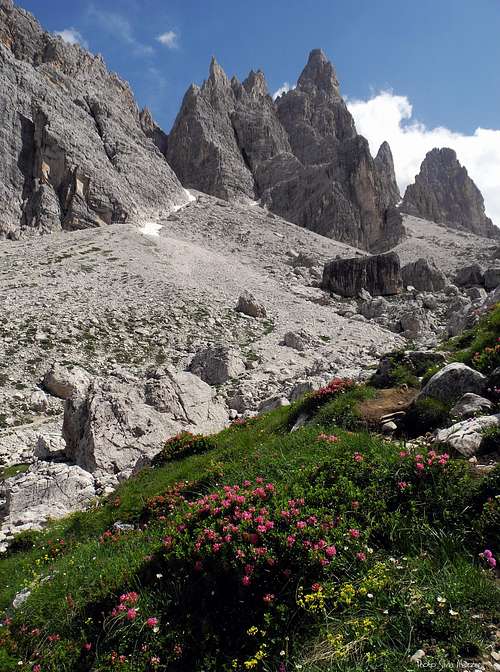
"Il Ruggito del Coniglio" is a beautiful route running on the left hand of the peculiar pyramidal West face of Campanile Federa, a superb spire overlooking the wild and lonely upper Val Formin. A direct line on excellent grey and carved “dolomia”, a steep and exposed climb on a compact wall located inside an astonishing environment, a fine summit with wide amazing views all over the Cortina Dolomites: all these distinctive features make this route an experience which can’t be missed, in spite of its rather long approach.
Getting There
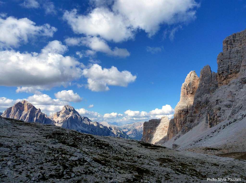
Approaching along Val Formin
Road access
The starting point is Ponte di Ro Curto m. 1695, along the road running from Pocol, near Cortina d’Ampezzo, to Passo Giau.
- From Belluno: follow the road SS 51 towards North, pass Longarone and reach Pieve di Cadore; from Pieve the SS51 turns to left, getting San Vito di Cadore and Cortina d’Ampezzo. From Cortina follow the road SS48 to Passo Falzarego. After 3 km., in Pocol leave the main SS48 and turn to left (signpost Passo Giau) following the road to Passo Giau.
- From Trento and Verona: take the Brennero Motorway towards North, exit Ora-Egna, then follow the road to Val di Fiemme and Val di Fassa, pass Cavalese and Predazzo; in Moena leave the main road and turn to right, following the Val di S. Pellegrino road to Falcade and Cencenighe Agordino. Here turn to left following the road to Alleghe, Caprile, Selva di Cadore, Passo Giau. From the pass descend along the other side, getting Ponte di Ru Curto.
- From Bolzano: take the Brennero Motorway towards North, exit Ponte Gardena and then follow the Val Gardena road to Selva di Val Gardena and Passo Gardena, reaching Corvara and La Villa. Turn to right towards Passo Falzarego, get the pass and here descent towards left along the road SS48 towards Cortina d’Ampezzo as far as Pocol. In Pocol turn to right and follow the road to Passo Giau (signpost) as far as Ponte di Ro Curto m. 1750.
Walking access
From Ponte di Ro Curto m. 1695 – parking area - follow the path n. 437 to Rifugio Palmieri, getting to the alpine hut of Cason di Formin (about 45 minutes from Ponte di Ro Curto). Here leave on the left the path to Rifugio Palmieri and follow on the right the path n. 435 to Forcella Formin and Forcella Ambrizzola (signpost). By a beautiful walking on this well marked path entering the amazing Val Formin, you’re reaching the upper tableland, just below the unmistakable pyramidal West face of Campanile di Federa. Here leave the main path getting the Forcella dei Lastoni and climb up the steep scree on the left, getting the bottom of the wall. A little cairn with a sling marks the starting point (2 hours from Ponte di Ru Curto).
Route Description
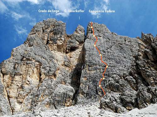
Il Ruggito del Coniglio (The Roar of the Rabbit)
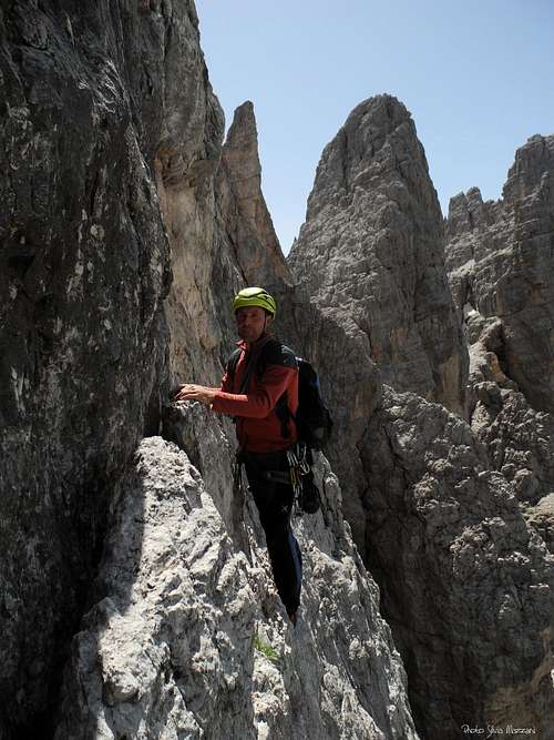
Ending the traverse
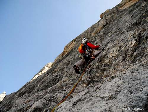
Upper wall
Il Ruggito del Coniglio (The Roar of the Rabbit)
Summit altitude: m. 2680
Difficulty: TD, UIAA VI-
Equipment: distanced fix, equipped belays
Climbing length: 280 m
Exposure: W
First ascent: S. Cannarella – G. Rosada – Margherita Sterni – Laura Albertacci summer 2002
Starting point: Ponte di Ro Curto m. 2100
The Roar of the Rabbit: sometimes the fixed protections – especially if distanced - don’t turn a rabbit into a lion. A provocative name for a route which remains demanding in spite of a handful of fix. A wonderful climbing on excellent steep “dolomia. The setting is alpine and secluded. The start of the route is situated in the left of West face, about 20 meters to the right of the edge. Little cairn.
Il Ruggito del Coniglio report - UIAA scale
P1 – Climb a vertical black wall, then slanting left reach a belay. V+, 25 m.
P2 – Up directly over the belay, then a few moves towards left, and finally traverse right on a narrow ledge. V+, 25 m.
P3 – Move slants to right, then climb directly. V, 25 m.
P4 – Climb a wall, then a crack. IV, 40 m.
P5 – Up on another steep wall, then a fine dihedral to a belay on a ledge. V, 45 m.
P6 – Climb a compact slab, slants to right, then slants to left, then traverse left on flakes to a crack. Climb it and traverse left to the belay. V, 35 m.
P7 – Climb directly a steep slab, then enter and climb a long yellow-grey dihedral. IV+, 50 m.


P8 – The crux pitch. Traverse left to catch a crack, becoming a chimney. Climb it, then a hard overhang on the right of the chimney. An easier chimney to the tiny summit. VI-, 35 m.
Descent: rapping on the same line (seven abseils, the starting two pitch of the route can be joined in one abseil)
Essential Gear
Rope 2x55 m, helmet, some excentrics and friends are useful to integrate the fixed protections, 10 quickdraws.
Climbing scale
| Rock Climbing Rating Systems | ||||||||
|---|---|---|---|---|---|---|---|---|
| French | YDS | UIAA | French | YDS (USA) | UIAA | French | YDS | UIAA |
| 1 | 5.2 | I | 6b | 5.10c | VII- | 7c+ | 5.12d | IX |
| 2 | 5.3 | II | 6b+ | 5.10d | VII | 8a | 5.13a/5.13b | IX+/X- |
| 3 | 5.4 | III | 6c | 5.11a | VII+ | 8a+ | 5.13c | X- |
| 4 | 5.5 | IV | 6c+ | 5.11b | VII+/VIII- | 8b | 5.13d | X |
| 5a | 5.6 | V- | 7a | 5.11c | VIII- | 8b+ | 5.14a | X+ |
| 5b | 5.7 | V/V+ | 7a+ | 5.11d | VIII | 8c | 5.14b | X+/XI- |
| 5c | 5.8 | VI- | 7b | 5.12a | VIII+ | 8c+ | 5.14c | XI- |
| 6a | 5.9 | VI/VI+ | 7b+ | 5.12b | VIII+/IX- | 9a | 5.14d | XI |
| 6a+ | 5.10a/5.10b | VI+/VII- | 7c | 5.12c | IX- | 9a+ | 5.15a | XI+ |
Red Tape
No particulary restrictions in climbing and hiking; Campanile Federa is situated inside Pelmo and Croda da Lago Area, one of the Dolomites’ nine areas admitted in the year 2009 in the list of Unesco Natural Sites. More info about Dolomiti Unesco World Heritage on SP in my dedicated article: Dolomites living mountains
Unesco Official website: Dolomiti Unesco


When to climb
Best season goes from the end of June to the end of September
Meteo
ARPAV Dolomiti Meteo
Dolomiti Meteo Veneto
ARPAV DOLOMITI METEO Phone +390436780007 fax +390436780008 CENTRO VALANGHE DI ARABBA Phone +390436755711 fax 043679319 e-mail cva@arpa.veneto.it
Where to stay

- Rifugio Palmieri
- Rifugio Passo Giau m. 2236 just on the col Link: Rifugio Passo Giau
- Col Gallina Hut on the SS48 between Passo Falzarego and Pocol
- Several possibilities in Cortina d’Ampezzo
Guidebooks and maps


“Arrampicare a Cortina d’Ampezzo e dintorni – Le vie più belle nelle Dolomiti” by Mauro Bernardi, Ed. Athesia
“Dolomiti Orientali Vol. I – Parte I” by Antonio Berti - Collana Guide dei Monti d’Italia, CAI TCI
Maps:
Tabacco sheet 03 – Cortina e Dolomiti Ampezzane 1:25.000
Kompass 1:50.000 - sheet 55 - Cortina d'Ampezzo