
-
 2873 Hits
-
 76.66% Score
-
 7 Votes
|
|
Route |
|---|---|
|
|
46.51146°N / 10.99935°E |
|
|
Download GPX » View Route on Map |
|
|
Hiking |
|
|
Summer, Fall, Winter |
|
|
Half a day |
|
|
Hike and Scramble |
|
|
Overview
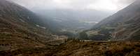
 Manndlspitze (left) and Ultener Hochwart (right) from Malga Cloz Manndlspitze (left) and Ultener Hochwart (right) from Malga Cloz |
In contrast to the East Ridge Route, which starts at the same trailhead, there is little to recommend about the route across the south slopes of Ultener Hochwart / Vedetta Alta. The first half is a hike along well kept and well marked traails, some of which runs allong Sentiero Bonacossa, the panoramic trekking trail from Gampenjoch / Passo Palade to Rabbi. In this section the trail always stays a little beneath the timber line and in a few places it runs across brittle slopes.
Once it reaches the Kesselalm pasture, however,, everything changes. Suddenly you are on the extremely brittle south slopes of the mountain. Maps indicate two different routes which turn out to be barelly marked and as you grope for your way you may switch from one to the other. If it were not for the summit, which clearly marks the destination, the route would be vary hard to find. In its topmost part it gets very steep and brittle making the ascent a real torture.
IMHO this route should only be done as a ski tour in winter when the snow cover hides the choss underneath.
Getting There
See the main page for the itinerary to Hofmahdjoch. The saddle itself can't be reached by car, as a tunnel cuts through it but before and after (better) there are parking lots. Right after the tunnel (to its south) a dirt road turns off to Malga Cloz / Cloz Alm.Route Description
- Start altitude: 1700m
- Summit altitude: 2627m
- Prevailing exposure: South
- Type: Hike and Scramble
nbsp; - Protection: None
From the southern parking lot at Hofmahdjoch retrace your steps for 200m, cross the road and enter on a dirt road, which leads to Malga Cloz / Clozalm. After several hundred metres you will reach the farm building, where several trails meet. Head out of the farmyard on its western side but immediately turn northward on trail no 7, which heads up the meadows above the alm. At first it follows a dried-up creek but then steeply crosses the meadows. After about an hour you'll reach the upper Clozalm near Glazner Joch Saddle, another trail intersection. The crossing trail Sentiero Bonacossa (no 133) leads west, always staying close to but beneath the timber line.
 |  |  |
Afer a while it reaches the valley of the Mairbach Creek, which is cut deeply into the south slopes of Ultener Hochwart / Vedetta Alta. In this place the littlle Kesselalm pasture can be found, after which a steep gully leads northward towards the mountain, leaving Mairbach Creek. Follow the signs and head up for some 100m until you reach a slope traversing trail. Turn west on it; it follows the valley of the Mairbach Creek in westward direction.
 Summit "view" into Ultental / Val d'Ultimo
Right before the valley ends turn north again where you quickly reach a broad valley heading for the west schoulder of Ultener Hochwart / Vedetta Alta. Follow the Valley until you reach a small lake. Here turn right and begin the summit scramble. Running across a rib at first, the trail remains fairly easy but the higher you get the steeper the trail. Additionally wear and tear has cut it down into the soil laying bare the underlying choss. In many a switchback - and with many a false start due to ambiguous markers - you'll reach the west ridge of the mountain just short of the summit, from where the remaining few steps are very easy.