
-
 6805 Hits
-
 83.1% Score
-
 16 Votes
|
|
Mountain/Rock |
|---|---|
|
|
46.65980°N / 10.63650°E |
|
|
7906 ft / 2410 m |
|
|
Overview
Geographical Classification : Eastern Alps > Ötztal Alps > Köpflplatte / La Lasta
With a mere 2410m Köpflplatte - or La Lasta, as it is known in Italian - is one of the least impressive summits of the Ötztal Alps. Located in the Saldurkamm Subgroup to the south of the Ötztal Alps it makes up for that lack in height by its perfect location. The Vinschgau / Val Venosta Valley bends northward at the town of Schluderns / Sluderno and it is here, directly to the north of the bend that Köpflplatte is located. The valley floor at that spot has an elevation of a mere 900m and this results in a perfect vantage point for viewing the Ortler - Cevedale Group to the south and the Sesvenna Group to the west.
The Saldurkamm Ridge of the Ötztal Alps is one of the loneliest regions you can find in the centre of the Alps. Apart from the main trafficway through Vinschgau you can only find very small hamlets hidden deep in the impressive valleys. The general elevation of the Saldurkamm Ridge reaches way above 3000m but the valley floors start at 1000 - 1500m. Therefore a climb of any of the summits of the group is a major undertaking - you certainly will have to climb more than 1000m.
The outlying summits - like Köpflplatte - form shallow overgrown ridges which are used for extensive cattle and sheep grazing. On the lower slopes you might come across a quasi wild flock of Haflinger horses but that will be all the civilization you will encounter. Nominally there are some four routes to the summit but all are very tough to find. Halfway up the mountain the paths vanish and from there on it is a bushwack - scramble combination which gets you to the top.
The summit is very exposed to high winds. There is supposed to be a shelter right west of the summit but during our visit we were not able to find it. Therefore be sure to bring wind-stopping clothes. Köpflplatte is one of the starting points for the beautiful ridge traverse Köpflplatte (2410m) - Schwarzer Knott (2811m) - Hohes Kreuzjoch (2992m) - Unteres Kreuzjoch (2763m) - Runnerköpfl (2593m). Due to the elevation gain (1600m+) this traverse is hiked / scrambled only very rarely, however.
Please excuse the poor quality of the old pics.
 |  |  |
Summit View
Hasenöhrl (3257m)Grabensprungspitze (3014m)Tuver Spitze (3097m)Flimspitze (3113m)Schwarzwand (2775m)Jennwand (2962m)Orgelspitze (3305m)Schluderspitze (3141m)Schluderzahn (3258m)Lyfi Spitye (3352m)Äuß. Pederspitze (3406m)Schafspitz (2657m)Schafberg (3306m)Tschenglser Hochwand (3375m)Pederfick (3114m)Ortler(3258m)
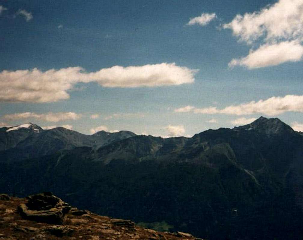 | 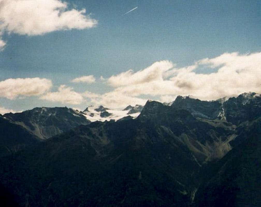 | 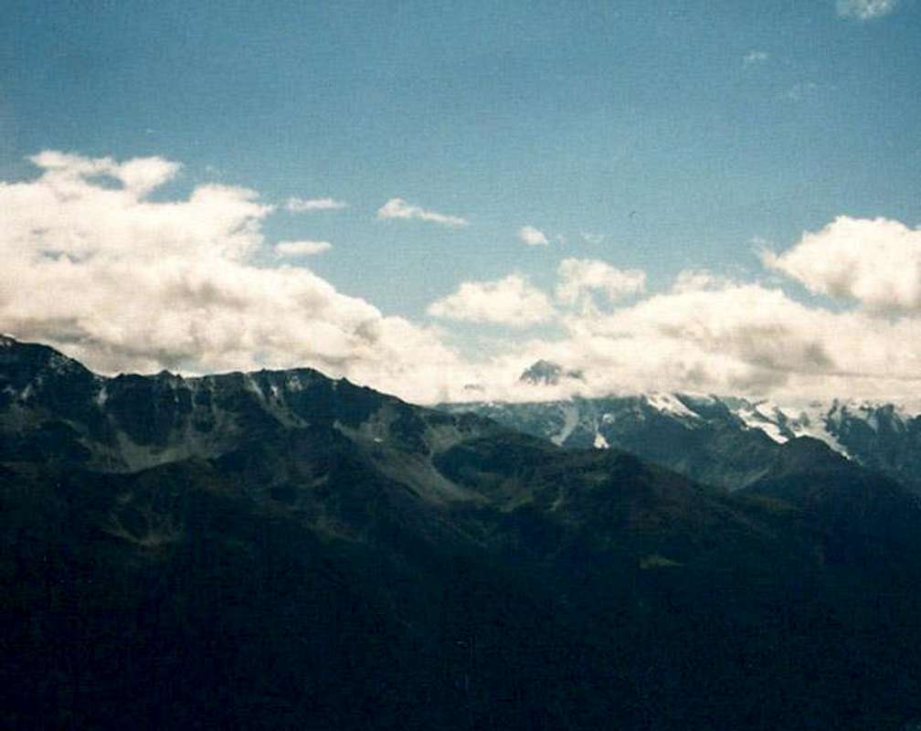 |
Summit view from Köpflplatte / La Lasta taken in September 2001.Hide / Show Annotations
Getting There
The most reasonable trailhead for the climb to Köpflplatte is located at Tannas / Tanas on the northern slopes of the Vinschgau / Val Venosta Valley. You also can start from Schluderns / Sluderno but that means an additional 500m of elevation gain.
From Italy
Take the Brenner motorway (A22) which you leave at Bozen (Bolzano) south. Take S38 (Vinschgauer Staatsstrasse) northwards towards Meran (Merano). The road follows the Etsch (Adige) Valley into Vinschgau (Val Venosta). Follow the road westwards until you reach Laas (Lasa). Here a side road turns off north towards the hamlet of Allitz. It follows the slopes towrds Tanas. There is a parking place at the eastern part of the village.
From Austria
Take Inntalautobahn (Motorway A12) westward from Innsbruck to Landeck. At Landeck turn onto road 180 which winds its way upwards the upper Inn valley towards Nauders. Between Nauders and Reschen (Résia) you cross the border and are directly on the shore of Reschensee (Lago di Résia). Go on until you reach Schluderns / Sluderno. In the town head for a side road which climbs the northern slopes of the Vinschgau Valley towards Tannas. In 2001, when we visited this road was closed due to a landslide. Since these slides are far from uncommon it pays to inform yourself beforehand. If the road is closed, take SS38 to Laas and from there follow the side road north to Allitz and Tannas.
From Switzerland
Take motorway A3 from Zürich or E43 from Bregenz southwards in the direction of Chur. Shortly after the motorways meet turn off onto road 28, direction Davos. Behind Davos at Susch the road splits (27 / 28). You can take either roads - the southern one (28) leads you over Ofenpass (Passo dal Fuorn) into Vinschgau (there take SS40 northwards to Schluderns), the northern one (27) goes to the Swiss Austrian border near Pfunds where you turn southwards again on 180 and head for Nauders, Reschen and Schluderns.
Red Tape
There is no red tape to speak of. Leave-no-Trace rules apply but nothing more. Take care of the grazing cattle and (especially) horses. Close any gates you have to cross.
When To Climb
Köpflplatte / La Lasta is an all year location. Due to its location on Vinschgau's sunny side it doesn't see much snow in winter. If it does a ski or snowshoe tour is highly advisable. The terrain is very smooth and the ridge traverse across Hohes Kreuzjoch should be easier in these conditions.
Accommodation
For accommodation you can contact the Vinschgau Tourism office at
Tourism association Vinschgau
Kapuzinerstraße, 10
I - 39028 Schlanders
Southtyrol - Italy
Tel. +39 0473 62 04 80
Fax +39 0473 62 04 81
E-Mail : vinschgau@suedtirol.com
Web page: www.vinschgau.org
Another worthwhile web page is www.suedtirolerland.it.
Weather Conditions
For up-to-date weather information look up the following link:
www.south-tirol.com
Maps 'n' Books
Maps
- Vinschgau / Val Venosta
Kompass Map WK 52
1:50000
Kompass Verlag
ISBN: 3-85491-058-4
- Latsch, Martell, Schlanders
Tabacco Map 45
1:25000
Editione Tabacco
Maps Online
Book
- Vinschgau / Ortlergruppe
Kompass Hiking Guidebook 950
Kompass Verlag
ISBN: 3-85491-404-0