


Comments
No comments posted yet.
|
|
Trip Report |
|---|---|
|
|
39.45565°N / 73.56704°E |
|
|
Aug 5, 2015 |
|
|
Mountaineering, Mixed |
|
|
Summer |
The plan was to do something exciting, something new. Not any of these routes which will be attempted from tens or hundreds of tourists every year.
A friend came up with the idea to visit the Transalai and climb Kurumdy with a group of the Austrian Mountaineering Club. Because I know the problems of those big groups I was going to bring together a small team for my own try: Katharina Pfnaisl, Melanie Grünwald, James Lam and me (Markus Gschwendt).
We could not find much information about the whole mountain range. Just one confirmed ascent to the main summit, russian military maps and a view expedition reports about 5000m summits.
Finally I had some problems to get my permit for the border area because my passport and other documents got stolen a month before the expedition. So we got directly to the Transalai instead of rock climbing to Karavshin.
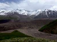
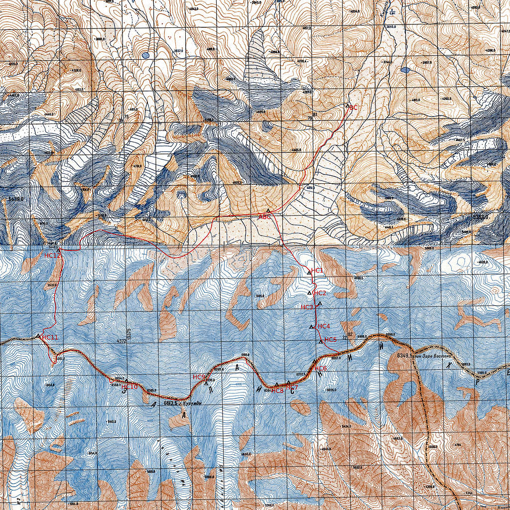
Finding a place for basecamp was easy and a week after arriving in Osh we set up our tents behind the west moraine of the East Kyzilsy Glacier at 3770m.
My personal style is to travel with less support from agencies and organize most things myself. On this trip we did it the same way. The only help were two horsemen and two horses to carry all the food and equipment until the basecamp.
The horsemen did not take the way along the moraine James and me checked out some days earlier and we could not convince them to no ride over a 4000m peak. This was too much for the horses. We had to leave some bags on the summit and do a back carry the next day.
Next we checked out a place for an advanced basecamp and were successful at 4100m. A small place with a big rock and some signs of a former camp. Behind the camp follows a long moraine which is nasty to walk because of the steepness and the loose big rocks.
We climbed a 5155m summit named Ekishak by the 2007 expedition.
We took a slightly different approach left of the couloir through a steep snow field, then walking towards the ridge, traversing blow the ridge towards the summit to find a good place to climb the cornice and reach the summit. The descent was real fun by just sitting in the snow and sliding down for 700m.
After some relaxing days in basecamp we decided to try Golova Orla 5440m a peak which is at the far end of the valley.
With supplies for 4 nights and without any idea if it is possible to cross the big serac fields we saw from the distance we gave it a try. Again we used the ABC for a night. We found a way around the seracs and after eight hours walking we set up our tents on the glacier at 4800m in a small basin below the peak. Melanie was fighting bacterias she got in Osh and decided to stay in the highcamp. James, Kathi and me tried to climb the face right of the summit. But we got stuck at a crevasse. We had to traverse south and climb the north face left of the summit and follow the ridge. The summit was a big cornice. The ice axes hardly found hold in the rotten snow and ice. Finally I could climb it and belay the others to the top of Golova Orla.
Then we had some days in basecamp. The other party from Austria arrived and made camp 20 minutes below of ours. They had the luxury of a cooking team, a mess tent, a bath tent and a toilet tent. For one evening we were their guests but we would not have changed with them.
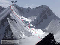
The weather forecast was bad for at least a week. But we packed big rucksacks and left camp. After repacking in ABC we crossed the glacier towards a steep 1500m face between Kurumdy East summit and Zarya Vostoka.
On the third day Meli was not better with the bacterias and James was not excited about the weather forecast which was still announcing bad conditions for the next nine days. They decided to retreat. Kathi and I wanted to try to reach the crest of the ridge and than - if the weather permits - do a first ascent on Kurumdy East II or a new route on Zarya Vostoka. With the two friends the SAT-device was gone. Now we only had a Radio for communication with the other group. My altimeter was broken. A russian military map and a compass would lead us from now on - old school.
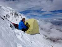
After another night on 4500m we started to climb the slope. Deep snow until the bergschrund. Than exhausting 10 meters vertical lose and rotten snow with a 30kg rucksack. Hard to find spots for ice screws. The conditions in the face were better. Climbing until dusk and then traversing to the rocks left of us. After an hour we had put together just enough snow for a platform to support the small tent. To not loose anything we secured everything with ice screws.
During the next day we has light snow fall and small snow slides during climbing. Most belays were good with screws - only at two spots it was almost impossible to setup a proper belay station. A second time we had to build a platform. But the snow was not as good as below. Inside the tent it was like sleeping on a barrel where it goes down on both sides.
For a few moments we had sun and blue sky in the morning before the clouds fell in again. The face was not as steep from now on but the snow deeper and sometimes I had to dig my way through crystal sugar snow which reached to my hips. Exhausting and frustrating. Sometimes only 10 meters per hour. We couldn't reach the ridge that day and dig another place for camp.
Not really knowing where we are on that big face and just heading upwards in the whiteout we suddenly topped out. There was no discussion what to do now. It was just clear that this will not be the target and we headed west towards Kurumdy.
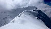
Finding the way on the ridge was not as hard. Even in the thick fog most of the time I could see a silvery line where the cornice and the void must be. Just follow it with a distance to not break through it. Because of many flat parts it would be no problem to set up a tent here.
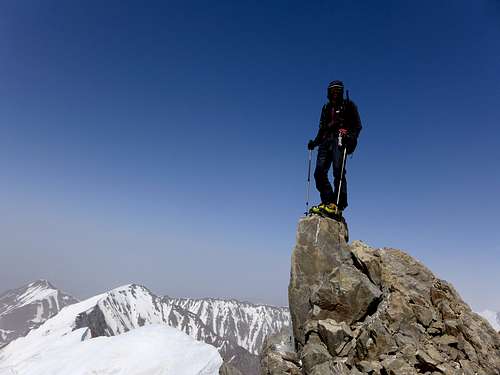
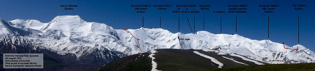
Next day we reached the unclimbed Kurumdy East II 6259 m. I named it Pik Kathi because it was her first 6000m peak.
I thought it would not be possible to get less sight. But a day later I had to stop. I could mot see my next step. After just 2 hours we decided to have a restday. Sitting in the tent, cooking, calculating food and gas and trying to find out how far we have come with the map and some pictures we had made the days before.
In the morning the sight was little better and the way to Kurumdy East I 6384m easy. From here we had the first time a view to the south side. Clouds are coming and going. Then we traversed all small 6000m summits an set up our tent below the east slope of the main summit. Perfect blue sky and strong wind. We build a snow wall to protect the tent.
The clear sky let the temperatures fall and the wind was freezing cold. But the cloudes came in again. One time I was shocked when the snow under my feet made a woom-sound and I changed my strategy of a zig zag line to go straight up to a field of gravel to get out of this avalange slope. After reaching some rocks it was flat and easy ground to the summit of Gora Kurumdy. We had reached our target as! The main summit of Kurumdy 6614m. We did the second ascent and were continuing to do the first traverse. And as a big gift the clouds shifted and the rest of the day was perfect. A overhelming view and an amazing landscape. The next big summit on the ridge looked great. The still unclimbed double summit of Kurumdy West I 6554m/6558m. We made Camp just before it.
No luck withe the weather. Fog again and on the smaller peak of the double summit I could not see anything. When the view got a little better I decided to head down immedetly and not to climb the just 8m higher south peak which would be just 20-30 meters from the col. The sight got better during the day. In a steep section Kathi fell and tumbled over but stood up and was well. Just before the last 6000m summit it got windy, very cold and and foggy. On Pik Chorku (Kurumdy West II) 6283m we found some from humans arranged stones. After some meters following the south ridge we were going around some rocks and traversing the west face to the northwest ridge. We set up camp for a windy night.
The next day we left the main ridge. The plan was to descend to a major north ridge which leads to our second acclimatisation peak Golova Orla 5440m. The strong wind had transferred snow from the south to the north face we had to walk down. I was not excited about the avalange risk but we had no choice. Following the west ridge would consume to much time and our supplies were already low. And so it came that I triggerd an avalange at almost 6000m. I was scared but happy that it was small enough to not get burried. we headed down between big crevasses and seracs to the north ridge. The first part of it was easy. Then we came to rocks. Loose rocks. Mixed terrain.
Not very hard but this needed much time. Several times we had to absail. In a crevacce not far from Golova Orla we had to set up another camp.
The way down from Golova Orla had changed a lot and not to the better. Already on the flat glacier I broke though the snow into a crevasse - luckily not completely and I could climb out myself. Late in the dark we found our ABC and were happy so sleep on solid ground again.
From this point on we felt really save. Just a days hike to the road. Even with big bags again because we had to clean up ABC and BC.
Back in Sari Tash we enjoyed relaxing and to have other people around. At this time we had not enough time left for climbing Pik Lenin and just waited for our flight home.
Markus Gschwendt