
-
 14472 Hits
-
 88.19% Score
-
 26 Votes
|
|
Area/Range |
|---|---|
|
|
29.25219°N / 13.50917°W |
|
|
Hiking |
|
|
Spring, Summer, Fall, Winter |
|
|
873 ft / 266 m |
|
|
Overview
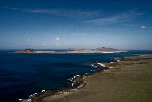 La Graciosa as seen from Risco de Famara La Graciosa as seen from Risco de Famara |
To the north-west of Lanzarote among the Islas Canarias you can find the smallish islands of the Archipelago Chinijo. They are five (sorted by size): La Graciosa, Isla de Alegranza, Isla de Montaña Clara, Roque del Este and Roque del Oeste. All islands are of volcanic origin but only the three former ones are large enough to be of interest. All islands are arid thanks to the fact that the perennial trade wind clouds rush by far too high to leave any precipitation other than an odd drop of morning dew.
Among these islands La Graciosa is by far the largest one. It is a veritable desert island, made up from sand dunes - and four volcanoes. Not much is known about the volcanism in the archipelago but generally it is assumed that the islands were created about 3000 - 5000 years ago, when across the straight on Lanzarote long and fierce eruptions changed the shape of the island completely. On La Graciosa two major and two minor volcanoes were created (see next section) and the land between was filled by ashes and sand.
Montaña AmarillaIsla de Montaña ClaraRoque del OesteMontaña del MojonMontaña BermejaMontaña Pedro BarbaIsla de Alegranza 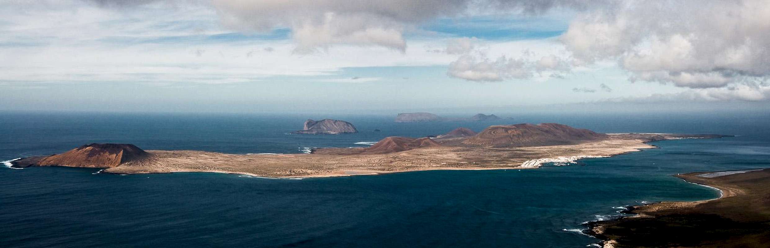  |
Today La Graciosa is a popular destination for all those who want to escape the sometimes hectic life on the larger Canary Islands. There are two villages, Caleta del Sebo, the ferry harbour and Pedro Barba a summer settlement. There is one small "supermarket" and the favourite means of transportation is a wheelbarrow. There are quite a number of Land Rovers (no other brand) of all kinds of ages which are used as taxis to shuttle the tourists from the harbour to the outlying beaches. Life is very relaxed for more than 23 hours of the day. Only the hour of the last ferry departure from the island can turn into a tourist stampede. Whatever you do on La Graciosa - if you don't plan to stay overnight - you'll have to hurry to take the last ferry back.
Apart from the surfing, kiting and beach going crowd, La Graciosa is also very popular among hikers. There is a northern loop and a southern one, both of which take the better part of four or five hours to complete. On these loops either Montaña Bermeja (north) or Montaña Amarilla can be climbed, both with beautiful views from their tops.
And then, of course there is Montaña Pedro Barba with its two summits Agujas Grandes and Agujas Chicas. It is the highest volcano on the island, hard to scramble up to but wonderful to lookout from. The hike and scramble from Caleta del Sebo takkes only 60 minutes and thus is a very interesting destination if you have enough time until the ferry departure. But most likely you will be forced to run ...
The volcanoes
Montaña Bermeja
 Montaña Bermeja on the north-west coast
Located in the north-west of the island, Montaña Bermeja is the northernmost outpost of La Graciosa. With only 152m it is the lowest of the four volcanoes. Its name means "Scarlet Mountain" and if you look at the deep reddish rock you'll understand why. The volcano is composed of red lappilli, the lava scree that makes any ascent a pain. Montaña Bermeja, however is old enough so that the lapilli have baked together. From Montaña Bermeja's top you have spectacular views of the neighbouring islands Isla de Montaña Clara and Isla de Alegranza.
Montaña Pedro Barba
 Montaña Pedro Barba seen across the straight between Lanzarote and La Graciosa
The largest and highest feature on La Graciosa is Montaña Pedro Barba, a twin-summitted and twin-cratered volcano. Its higher peak, Agujas Grandes is 266m high and one of the most popular hiking destinations of the island. The second summit, Agujas Chicas is 13m lower and accordingly much less visited. Agujas Grandes stands out for the waved patterns on its south side, which are plainly visible from Caleta del Sebo.There are two routes to Agujas Grandes. The shorter eastern one is extremely steep and brittle. You have to scramble up a cinder couloir towards the saddle between Agujas Grandes and Agujas Chicas. From there a short stroll takes you to the top, from which you have a perfect ooverview over La Graciosa, the Archipelago Chinijo and Risco de Famara on Lanzarote.
Montaña del Mojon
 Montaña del Mojon seen through the rocks at Punta Fariones
The second highest mountain of La Graciosa, Montaña del Mojon is 189m high. It is located to the south-west of the island "capital" Caleta del Sebo. It is a perfectly shaped crater, open to the east (rare in the area). The volcano is rarely climbed due to lack of time (ferry time table) and the fact that higher Agujas Grandes is close nearby.
Montaña Amarilla
 Montaña Amarilla above Playa de la Cocina
The yellow mountain, Montaña Amarilla is located at the southernmost end of La Graciosa. Seen from Lanzarote it is the most prominent feature of the island though at 178m it is only third in height among the volcanoes of the island. Its real beauty can only be seen from up close, especially from Bahia de la Cocina, the bay above which the east face of the mountain towers. This face is a combination of brightly yellow or ochre tuff capped with an equally bright layer of red lava. Like Montaña Bermeja, Montaña Amarilla is a wonderful place to look across the Archipelago Chinijo.
Getting There
 The ferry harbour, Caleta del Sebo
Getting to La Graciosa is a lengthy affair. Though there are ferries from the Spanish mainland to the Canary Islands, they take more than 24h for the trip. Therefore most visitors therefore go by plane. Every travel agency in Europe offers flights, hotel rooms, apartments, rental cars etc. so that reaching the Canaries is rather a matter of money than opportunity. During the summer season flight fares can be reasonable but during the Easter and Christmas holidays you have to be prepared for additional fees of 500€ per person.
Lanzarote has its own airport between the capital Arrecife and one of the main tourist centres, Puerto del Carmen. There are public bus lines but – like on all the islands – they don't run too regularly. If you plan to stay on your own, better take a rental car right at the airport.
From the airport take highway LZ1 through Tahiche and Arieta to Orzola, the northernmost village of the island. From the harbour the LLa Graciosa Ferry departs several times a day. The first departure is at 10:00 a.m, the last return ferry is at 4 p.m. in winter and 6 p.m. in summer. On La Graciosa the ferry lands at Caleta de Sebo from where within 2h you can reach the summit of any of the four volcanoes of the island.
Red Tape
 Basalt bridges on the north coast of La Graciosa
The whole island of La Graciosa belongs to the Parque Natural del Archipelago Chinijo. In this natural park the usual restrictions apply. La Graciosa is a desert island so any single plant or animal is unique. Don't pluck any flowers, don't disturb any animals, most notably nesting seabirds. In reality you'll be hard up to find any of both kinds.
Accommodation
La Graciosa doen't offer too many accommodation possibilities. Generally, most visitors take the first ferry in the morning and return by the last. If you miss the ferry there are opportunities to find a bed - you simply need to ask anyone who's hanging out at the harbour of Caleta del Sebo.There is a campground to the south of the village. Like everything on the island it is dry and sandy. However, a 15 minute walk will take you back to Caleta del Sebo.
As for holiday homes, hotels or apartments on Lanzarote either consult your nearest travel office, or – search for lodgings on Google. There are several sites on the web, dedicated to rent privately owned houses or apartments. Prices are generally a bit less expensive than for tour operators but you don't have as much security. With a bit of luck you even might find something in Caleta del Sebo but don't expect any luxury.
External Links
Maps & Books
Maps
Regular Maps
- Lanzarote
Kompass Map WK241
Kompass Verlag
1:50000
ISBN 3-85491-175-0
Digital Maps
Kompass is the only company known to me which offers GPS digital Maps. In addition for those of you with Garmin GPS receivers there is a map source map set of all Canary islands out there.
- Lanzarote
Kompass GPS4241
Kompass Verlag
ISBN 3-85491-223-4
- Islas Canarias
Map Source custom map
By Manfred Pepper
downloadable zip-file
Books
My recommendation is a guidebook by Rother Verlag, available in German. The book is an excellent hiking guide covering all the interesting areas of the island. Since it comes with small maps for each excursion it might even be used without a map to support them.
- Lanzarote
Rolf Goetz
Rother Verlag
ISBN 3-7633-4302-4