
-
 3806 Hits
-
 74.01% Score
-
 4 Votes
|
|
Route |
|---|---|
|
|
36.82512°N / 3.84011°W |
|
|
Hiking, Scrambling |
|
|
Spring, Summer, Fall |
|
|
Half a day |
|
|
Class 4 |
|
|
Hike and exposed Scramble |
|
|
Overview
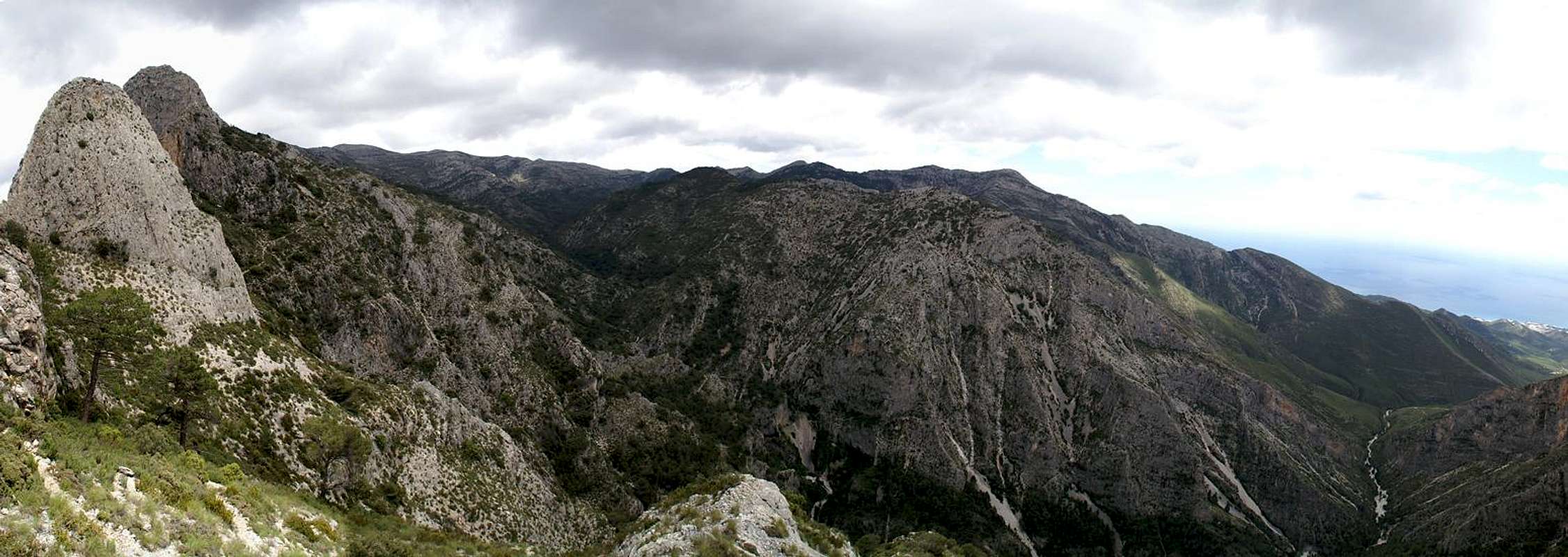
 La Puerta above Barranco de Cazadores La Puerta above Barranco de Cazadores |
The southern route to the Almendron summit is the shorter and easier one of the two. It strives for a saddle between the massive walls which close in Barranco de Cazadores and follows the ridgeline to the saddle La Puerta. There a big tower is passed on its eastern side after which the steep traverse of the Almendron east face follows.
Up to La Puerta orientation is easy but the traverse is trail-less with many possibilities of loosing the way. The best way is to cross the east face nearly all the way to head for the Almendron north ridge for the final ascent.
Getting There
 Costa del Sol above Barranco de Cazadores
The main page describes how you can get to the Almendrón trailhead. The routes start at the picnic area El Pinarillo, which is located at the mouth of Barranco de Cazadores.
Route Description
  |
- Start altitude: 300m
- Summit altitude: 1514m
- Prevailing exposure: E
- Type: Hike and exposed scramble
- Protection: None
From the parking lot in Maro follow the dirt road which leads to the picnic area El Pinarillo (also possible by car). Cross the picnic area and descend into the barranco, only to climb out of it on the other side. You'll reach another dirt road which you have to follow to the right. Take the left turn at the next intersection and the road leads you down into Barranco de Cazadores. After 500m, at the next intersection, again take the left turn. The road now winds westward and after a long loop a path turns off to the right.
The path heads for a saddle which it crosses to the western side of the ridge. It circumvents the southernmost summit of the Almendron south ridge, turns around it and climbs a valley to the saddle to the north of it. From the saddle you have great views of the eastern Sierra de Almijara as well as Barranco de Cazadores.
The route now basically follows the ridge, at first keeping on its western side. You reach the tower at La Puerta, where you pass back to the eastern side of the ridge. The tower is passed at its eastern base and then the long traverse of the Almendron east face starts. Descend a few steps to cross a shallow valley but then keep climbing until you have passed the Almendron summit. You pass a ravine after which you shold follow the path for another 300 - 400m before you turn west to attain the Almendron north ridge.
Follow the ridge on its eastern side. A scramble takes you to the blocky part on to where you have to cross over to a ledge on the very exposed western side of the mountain. The ledge leads to a small almond tree near the summit of the mountain, from where a second exposed climb takes you to the top.
 |  |  |  |  |