

-
 28787 Hits
-
 84.27% Score
-
 18 Votes
|
|
Canyon |
|---|---|
|
|
Canyoneering |
|
|
Summer |
|
|
Overview
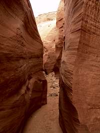
Labyrinth Canyon is a boat accessed slot canyon located in Lake Powell. The mouth of the canyon is located in Utah and the rest of it is located in Arizona. Current water levels make the canyon accessible to its fullest degree. If the water level rises even by as little as ten feet, a majority of the canyon will be underwater. This is a great entry level slot canyon with a few technical moves.
Getting There
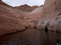
This canyon can only be accessed by boat. The nearest city is Page, AZ. Parking can be obtained for a fee at Antelope Marina, this is the nearest put in and it is eleven miles from the mouth of the canyon. After putting into Lake Powell follow the mile marker buoys until you reach number 18. At this buoy head in a southeastern direction until you reach a white buoy with " Labyrinth Canyon " printed on it. Here follow the main channel until your boat no longer fits, at this time you need to be on shallow water boat, such as a kayak or canoe. Bring the boat ashore in the mud that smells like sulfur. There are several warm springs emerging from the rock as you proceed into the beginning of the canyon.
Route Description
The beginning of the canyon is about six feet wide and has several small streams flowing into it. After several hundred feet the canyon becomes dry and sandy. It quickly narrows and becomes only shoulder wide. This continues until the canyon opens up into a wider more relaxed section. At this point, a choice must be made whether you want to continue with the obvious slot canyon to the right, or scramble up and over and see where the other fork goes. Due to time constraints, I only ventured right. The canyon then narrows again and this is probably the most enjoyable section of the whole thing. Soon after the canyon enters a more technical section, there are small potholes that have several inches to several feet of water in them.
These potholes are not big enough to swim in, but are challenging because once your feet are wet, the walls of the canyon become much more slick. Toward the last third of the canyon there are several rocks lodged in your path that make normal passage impossible. Bouldering/Scrambling moves are required to get over several of these obstacles. The crux of the canyon comes in the form of a deep pothole, followed by a sandstone trough leading to a 6-foot overhanging boulder. This rock must be done in order to top out of the canyon, I suggest the stronger of your party goes first and helps the others up.
After you get over the crux there should evidence of a large water basin that has been created by the waterfall above that only occurs during the monsoon season. This should be on your right. Go another hundred feet and climb any of the animal trails to the right. From here there are several trees to sit and relax under.
Red Tape
As soon as you leave the water and set foot on dry ground you are technically on the Navajo Indian Reservation. I do not suggest that you camp anywhere along the canyon, or on the mesa above the canyon unless you have permission from the Reservation leaders.