
-
 5327 Hits
-
 73.06% Score
-
 3 Votes
|
|
Route |
|---|---|
|
|
42.85837°N / 0.35041°W |
|
|
Hiking, Mountaineering, Mixed |
|
|
Spring, Summer, Fall |
|
|
A long day |
|
|
Class 4 |
|
|
PD (poco dificil, low difficulty) |
|
|
II |
|
|
Overview
This is the classic and most beautiful route to the summit of Lurien. Nowadays it's possible to evitate some meters of slope in the train of Artouste but it's not advisable.Slope: 1580m
Time: 4h 30 min or 5h to summit (Total: 9h)
Getting There
 Trailhead
See the main page to approach to the zone of lake of Fabrèges. In the middle of the parking of the lake we must search a little path with the signal.
Route Description Pt 1: Fabrèges-west ramp
 Col Lurien
We begin in the post of the sign in the middle of the parking of the lake (at present the signal is fallen and only the solitary post of wood indicates the direction). Initially a strong slope goes for the pretty forest that contains small rivers. The path is perfectly signaled with cairns until arriving at a great plain after the forest. We walk for the center of the valley between the walls of rock and soon appears to ours right the surprising image of the peak of the Midi d'Ossau.
 Barrier
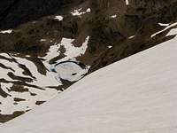
In the middle of the valley it's the hut of Lurien (Cabane de Lurien), free hut to rest a little time. We follow near of the river turning to right to reach a little col at 2115m under a rocky spun in left side. We turn to enter in a narrow pass (following the cairns of stones) in left side. After a first little lake we reach the nice lake, the Lac du Lurien (2211m) with the first view of the west face and the summit of Lurien in front of us. After a short walk-up we reach the wide Col of Lurien (2342m). We see the entry of route from Lake of Artouste in left side but the direction to the summit it's evident in right side. The only point of access it's a little barrier of rock. After this first little climb (grade I) we reach the bottom of the west ramp of the peak. This ramp it's covered by the snow a lot of time and because the important inclination it's advisable the use of winter material (crampons, ice-axe). Without snow it has a lot of stones and the walk is easiest.
In the middle of the ramp, when we see the highest point of the ridge to ours left, we have two options, the nortwest ridge (left) or the west ridge (right)


Route description Pt 2: access to the ridge
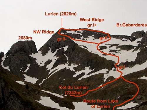 Sketch of routes
a) NW ridge- turn to left side to search the entry of the couluoir of 35-40º (without snow it's a easy climb of II-) reaching the NW ridge. A path goes in the west of the ridge to the summit in a short walk. Without snow it's probably the easiest route and the most advisable.


b) West ridge- we follow in SE direction to the end of the west ridge. Before the end of the ridge in a great gap (Brecha de Gabardères) we turn to left in direction to a visible chimney. With snow the last part to reach the chimney has 40º. The short chimney of II (PD) permits to climb the wall that separates us of the ridge. The easiest ridge goes to the summit to left side (grade I+).


In the summit of Lurien, we enjoy of the great landscape.
Essential Gear
 Lac du Lurien
In winter or early in the spring (may-june) it's needed the use of crampons and ice axe in the hard slope of the west ramp.