What's New
Nov 01, 2006 Up to now, only minor corrections have been made to the original text written by
Gangolf Haub, the submitter of the route and its previous maintainer.
Nov 02, 2006 Made further changes, mainly to the images describing the route.
Approach
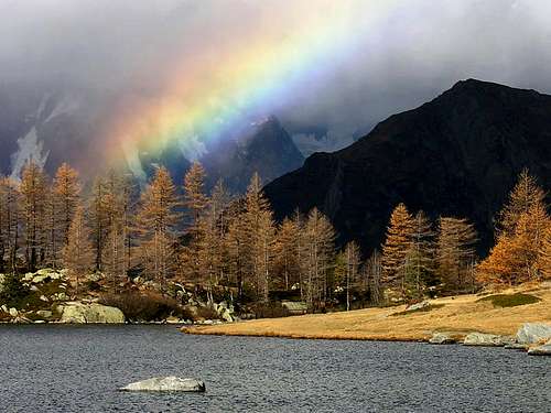
Rainbow at Arpy lakeAt Morgex, some thirty kilometers west of Aosta, you have to turn into a side road that climbs upwards through larch forests to the Colle San Carlo and eventually leads to La Thuile (and thus in the end to the Colle del Piccolo San Bernardo). There (in front of the Hotel Genzianella at Colle San Carlo) you can leave your car and start the ascent.
Route Description
Altitude gain: 1.200m Duration: 5h Trailhead: Colle San Carlo From the trailhead at Colle San Carlo head in the general direction of Lac d'Arpy. This is a weekend resort with lots of picnic places etc. Therefore over the weekend you will encounter quite a lot of people. The "lake" rather is a maze of small lakes and it is not so easy to find your way through. Head for the general direction of the valley and somehow you'll be able to disentangle yourself.
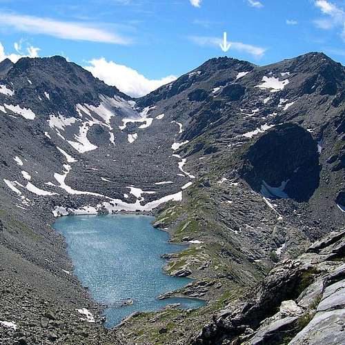
From the end of the lake you need to hike about an hour along the trail running alwayson the left of the waterfalls until you get to a wall wich has to be climbed using a ferrata wich is rather heavily secured. From the top of this wall take a couple of steps towards the first destination of the climb, Lago di Pietra Rossa. (You can avoid the ferrata going on the right and following the marks on the smooth rocks that lead, with some uncertainties, to the lake).
From this lake the trail leads over rocks and boulders towards the pass below Mont Colmet. This section takes forever and is not so very much fun! Don't miss the entry to the final ascent trail to Mont Colmet, which opens up after some 1 to 1 1/2 hours after leaving Lago di Pietra Rossa. The final and steep ascent is a very rough scramble through gravel, rocks and meadows (on the top). Slightly below the summit there is the ruin of a small military outpost. A couple of meters higher and you are at the summit with its closeup view of Rutor and all the 4.000m - Giants around.
Views from the Summit
Essential Gear
Hiking gear is sufficient in most of the passages. It might be a good idea to bring some rope for the final scramble. Combined with the tour over Colle della Croce the whole trip takes some
9h'00.

 7589 Hits
 83.1% Score
 16 Votes