
-
 2930 Hits
-
 75.81% Score
-
 6 Votes
|
|
Route |
|---|---|
|
|
46.52237°N / 13.88268°E |
|
|
Hiking, Via Ferrata |
|
|
Summer, Fall |
|
|
Half a day |
|
|
Medium hard walk up (T4 by the Swiss Hiking Scale), B/C for ferrata |
|
|
Overview

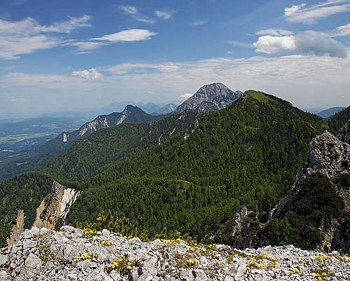
The summit ridge
On this half day round tour you can to a certain degree choose its difficulties and attractions you want to see, so no wonder that it is very popular. So, in the lower part you can extend the tour into the short gorge of Ročica/Rotschitza creek, where they have arranged a ferrata over its waterfalls. That can extend the tour for some 30 minutes. On the summit ridge you can also choose to go to the cross on the northern summit and so add a few minutes of easy rock scrambling. From some places along the route you have nice views down on Baško jezero / Faaker See, only the summit panorama is a bit obscured towards the south where the forested, and a bit higher Murnovec stands. So, of Julian Alps only a part of Martuljek group can be nicely seen.
Rating the Route (With Hiking Standards)
Eastern views
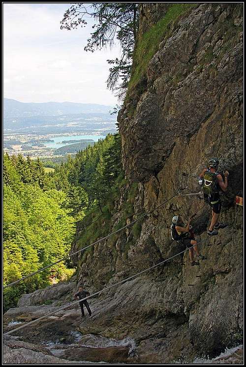
On the Ročica ferrata
The grading system for hiking and scrambling routes is here.
0. General: From 912 m to 1823 m, exposition N, E, S and W. At first through the gorge of Ročica creek (or passing it by), then through the woods on the upper meadows. The summit ridge is on some pleces narrow and exposed. From it you descend steeply towards the west and then return by mountain roads and comfortable paths back to the parking place. Gear: Good shoes and poles. For the ferrata less experienced will find a ferrata set useful. By the Swiss Scale for grading hikes the overall tour difficulty would be T3. The ferrata part is rated B/C by the Austrian scale.
1. Effort: 920 m, 3 h for ascent, 2 h 30 min for descent. If you skip the ferrata, some 5 h for the whole round tour.
2. Power: 3 - medium if you choose ferrata (otherwise 1 - only walk up).
3. Psyche: 3 - medium (a few places on the ferrata and on the summit ridge).
4. Orientation: 1 - no difficulties, well marked, the summit ridge is partly not marked, but evident.
Getting There
You best start the tour at Baumgartnerhof, 912 m, a nice pension above Altfinkenstein terrace. From the road which goes along the south bank of Drau/Drava you deter on the terrace either in Finkenstein/Bekštajn or in Latschach/Loče.
For broader overview the the parent pages.
Route description
If you go directly on the mountain, you start to walk up by the marked path No. 683 towards the south. If you go also in the Ročica creek, you follow the inscriptions towards the SE. Also from the path No. 683 you can get some 100 m higher, on the top of the ski slope, left to the lowest waterfall, where the ferrata starts.
The Rotschitza / Ročica Ferrata
Below the lowest waterfall you cross the creek and start ascendig over the plates up. Soon you reach an overhang, climb it and on top of it find two cables which cross the creek. Unfortunately in the beginning the upper cable (for hands) goes too much in front. The technique is to pull the upper cable with hands and to push the lower cable with legs, so you don't lean too much frontwards or lose equilibrium. Having no ferrata set it was even more important for me. The second passing of the creek on cables is a bit easier, then some more vertical rock sections come and two more crossings of water over the rocks. The ferrata overcomes only some 120 meters, during the climb we always have nice views on Baško jezero / Faker See.
Near Mitzl-Moitzl Huette
Maloško Poldne / Malestiger Mittagskogel Ascent
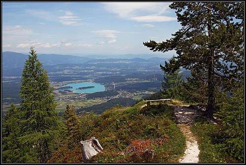
After exiting the ferrata, the path leads you right out of the gorge. After some 100 m you already reach the path No. 683, and continue by it uphills. In turns it goes all the time through the woods above the creek. On a nice lookout point (Gamsstand, 1240 m) the view into the creek opens for the last time, there the path turns a bit right. Partially through the woods, partially over some clearings it goes in turns up to the meadow where Panierhütte, cca 1400 m, stands. Above, a nice, light larch forrest begins. We walk close to the edge of steep northern landslides, but mostly by a shallow valley. Then the path crosses right over a small ridge to the private Mitzl-Moitzl Hütte (hut), 1639 m. On a nerby hill there's a cute bench with great panorama.
From the hut we already see our summits above us. Through a shallow, rocky ravine we ascend on the main Karavanke ridge, hitting a crossroads (plates). There we turn right and a nice, not marked ridge path soon brings us up on Maloško poldne. From it we continue down towards Ostra peč / Malestiger Mittagskogel (left goes an unmarked path along the frontier). In the ravine before this northern summit we hit the Austrian marked path No 684., coming up from the west. Following the marks you get to the cross in a few minutes. A part of this ridge route is narrow and a bit exposed, so it is also protected with steel cables.
Western Descent
From the northern summit you return to the crossroads, there turn right and start descending steeply towards the west. Later, the path No. 684 crosses the slopes towards the north, descending so around the walls of Ostra peč. Then it goes down to the highest forrest road. The return goes mainly by the roads. Only on few places the marked path cuts their turns. We pass the crossroads towards Iljč farm (going right), then the road descends into the valley of Rauscher Bach, after crossing the creek we leave the road and take the marked path which brings us to Zwanziger farm and further to Baumgartnerhof.
On return, don't forget to visit the ruines of Altfinkenstein castle! Nicely restaurated, a restaurant there.
External Links
In German: Rotschitza Klamm Klettersteig