
|
|
Route |
|---|---|
|
|
43.96070°N / 109.3393°W |
|
|
Steep Hike and Scramble |
|
|
A long day |
|
|
Grade II Class 2 |
|
|
Car Approach to the Trail Head
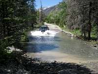 Driving in the river
 Trail head sign
From the town of Meeteetse, which is located about 32 miles south of Cody, turn west onto the signed road for Wyoming 290. The turn is located by the gas station. In 6.4 miles, turn left onto Wood River Road; at 11.6 miles, the pavement ends. The national forest boundary is at 21.7 miles, after you pass the Brown Mountain campground. Continue on the road as it climbs and crosses a few minor streams until you reach the main crossing of the Wood River, which in June and early July can be an exciting experience, but in late season is mostly rocks with little water. Look for the Meadow Creek trailhead on your right a little ways further down the road.
 Francs Peak (photo: Bob Sihler)
Route Description
 Just above the treeline
 Meadow Creek
Ascend Meadow Creek for 1.5 miles into its basin. There are several campsites with early summer water available between 10,000' and 10,400' to lessen the summit day. The trail has a couple of easy creek crossings before you reach the large open meadow, which is about 3.5 miles from the trail head, according to a measured GPS distance by NavySeabee. Gain the headwall at the western end of the basin to reach the long undulating south ridge of Francs. The ridge is mostly wide but a few narrow spots will require some decision making and scrambling.
The distance to the summit of Francs Peak via the Meadow Creek route is about 7.0 miles with approximately 4800 feet of elevation gain.
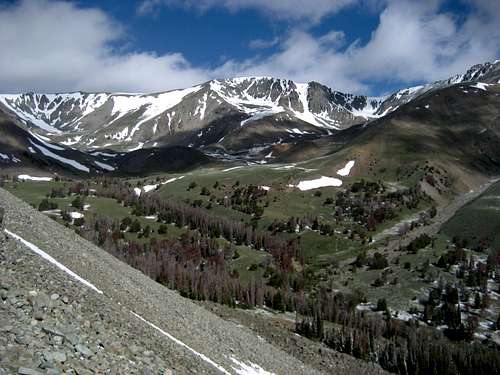 Meadow Creek Basin; your objective is the headwall at the center of the photo, which leads along the south ridge to the summit
Essential Gear and Miscellaneous Info
Bring wilderness backpacking equipment or full-weather dayhike gear; you can encounter numerous grizzly bears on this peak, and many summit register entries mention seeing anywhere from four to a dozen of them. Bring bear spray and know how to use it!The afternoon thunderstorms in this area can be intense, so keep in mind that you are on an exposed ridge for a very extended period of time.