
|
|
Trailhead |
|---|---|
|
|
40.60548°N / 111.69308°W |
|
|
8920 ft / 2719 m |
Overview
Mill B South is a trail approximately 4.5 miles in Big Cottonwood Canyon. This is a very popular trail, especially on the weekends. The trailhead is a big parking lot, right before the S-Curve. From the trailhead, there are two trails that branch off.
One is the Broadsfork trail, which obviously, goes up to the Broadsfork Meadow, and from there you can climb the Broadsfork Twin Peaks.
The Mill B South Trail, often referred as the Lake Blanche trail, obviously goes to Lake Blanche.
Lake Blanche is one of the most scenic places in the whole Wasatch Range. The Trail gains elevation at a steady pace the whole time. This means you don't ever loose any elevation, which is a real good thing. The trail is classified as a Class 2 trail, meaning it can be strenuous for the Average hiker, but not for an expert.
Lake Blanche Trail
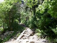
After you reach the trail, continue on the big road. This will eventually end. Before it ends, you'll see the Lake Blanche stream, mixing with the Cottonwood Stream. the stream goes along the trail some of the time. Right before this, the trail goes up southward, that is the Mill B south trail (aka Lake Blanche Trail).
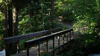
Stream Crossing
When you start hiking, you'll reach the stream crossing. There is also a bench to sit on there. Some people just hike until here and turn back, but the real journey has just begun.
Lake Blanche Valley
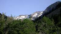
After that the trail curves and goes south again. Afterwards, the trail continues on still going along with the Stream and keeps going closer and closer to the Lake Blanche Valley.
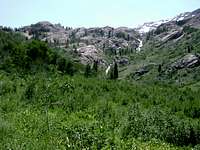
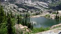
Lake Blanche Clearing. Sundial Peak is bearly Visible.
About half way there, you'll reach a place I call the "Broken tree place". This is the half way point. This place, according to the "Hiking In Utah" guidebook is a meadow or a clearing.
Lake Florence and Lake Lillian
The next portion of the trail is the shadiest. Tall Aspen trees block a lot of the sunshine from coming through. After some amazing Tree cover, the trail starts to switchback up the mountainside.There is a switchback near the end of the trail that goes over a small Boulder field. Make sure you keep going on the boulder field and curve until you reach the trail again. After you reach the lake, there are so many other places you can go. You can head down to the bottom two lakes. Lake Lillian, and Lake Florence, also very scenic.
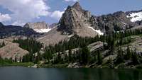
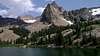
Sundial Peak.
This is the only peak I want to go into details because its so amazing to every extent.
Sundial Peak is one of the most amazing shaped peaks in the Wasatch. Sundial Peak really holds up to its name. Named for its natural sundial appearance, the peak really is a natural marvel. On a sundial, you have three points for the sun to cast a shadow to show what time it is, and when viewed from Lake Blanche, Sundial peak does indeed have three points. Its amazing how mother nature made a clock way before man even existed.
The different views of Sundial Peak.

From Lake Florence

From near the Boulder field
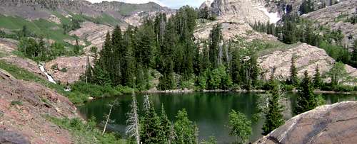
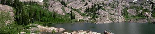
Lake Blanche.
Lake Blanche is the largest of the 3 lakes. Lake Blanche sits directly below Sundial Peak, and has a great view of Dromedary Peak, the back side of Superior, Monte Cristo, and the canyon below. At 8920 feet this is a very surreal scene. It is very peaceful, with big red rocks to view the lake from.
The water is a really nice blue, with green reflections of trees. When the sun shines in the water, it sparkles.
Lake Blanche looking South.
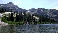
Lake Blanche looking West
Lake Florence
Lake Florence is the second and the smallest of the 3 lakes. a big stream from Lake Blanche, connects to this lake. This lake, like Lake Blanche, is a also very beautiful. You can also view this lake from the quartzite rocks. Also, like Lake Blanche, it has shimmering water, with sparkles during the sunlight hours. Lake Florence also has a view of Sunrise, Dromedary and Sundial Peaks.
 Panorama of Lake Florence with the stream.
Lake Lillian.
Lake Lillian is the third and last lake. It is almost Two-Third the size of Lake Blanche. This lake is also really beautiful and is also surrounded by quartzite rock. A small stream also connects Lake Florence to Lake Lillian and from there, all three lakes are drained down to the Big Cottonwood Canyon Stream.
 Lake Florence Panorama.
Waterfall
One more place you can go is, instead of climbing Sundial Peak, you continue on a trail that goes south, and this will lead you to a nice waterfall.
Obviously, lots of snow melts around this area. Lake Blanche is one of the major drainages. A waterfall comes off of Sundial Peak, and heads down towards Lake Blanche.
Peaks that can be Climbed.
Here are the many peaks you can climb from Lake Blanche.
Sundial Peak

Sunrise Peak

Dromedary Peak

Monte Cristo
For more information on these peaks, visit their pages HERE
Trail Info
Distance to Lake Blanche- 2 ¾ miles
Elevation Gain- 2720 vertical feet to 8920 feet
Some people often spell it as Blanche, but others might spell it as Blanch, so you might want to search both. In this thread, it will always be spelled as Lake Blanche.
Conditions
Depending on how much snowfall, the lake melts anywhere form Mid May to Mid June.
In the 2007 year, It melted in Mid May.
In the 2008 year, It melted In Mid June.
In the 2009 year, It melted in Late June.
External Links
http://www.localhikes.com/Hikes/Lake_Blanche_7160.asp
www.utahtravelcenter.com/activities/hiking/hiking-trailsnorth/lakeblanche.htm
www.utahtrails.com/Backcountry%20pages/Blanche.html
protophoto.com/subject.html?subject_id=615
utahpictures.com/LakeBlanche.php
climb-utah.com/WM/blanche.htm
Info on this page
Feel Free to add any Trip reports, Albums, Etc.... This is NOT a private page, IT'S public
Please if you have any pictures at all of Lake Blanche, post them on this page, or if you have already uploaded some, just attach them.