
-
 5095 Hits
-
 79.04% Score
-
 10 Votes
|
|
Route |
|---|---|
|
|
46.42144°N / 13.15235°E |
|
|
Hiking |
|
|
Spring, Summer, Fall |
|
|
Half a day |
|
|
Easy walk |
|
|
Overview
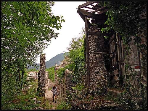
The ruined part of Moggessa di qua
This is a special hike - no summits, no broad panoramas, just wandering through a land which was once populated, but is now almost completely abandoned. Yet, people are still living in those villages. A few old, solitary inhabitants who don't want to quit. Hundred years ago, in Moggessa there were 200 people living. Then they started to leave for a better life and the final strike was the earthquake in 1980-ies, after which no significant renovation was done.
On this tour we shall visit three villages which even nowadays no road reaches. It's 1 h 30 min walk to Moggessa di qua (Muiesse di ca) and the same amount of time to Stavoli from the nearest road. And to Moggessa di la (Muiesse di la) even 30 minutes more. The route will lead us by old, paved paths which for centuries people have used. From Moggessa di la to Stavoli there's a narrow path, scarcely marked, but not difficult, even if we are walking through wilderness. In summer you will welcome several nice ponds of crystal clear water in the creeks, flowing towards the south. All in all, this is a tour which you should do when due to certain reason higher mountains are not an option. We went on a hazy, stormy June day, just appropriate for those gorges. We expected nothing much attractive, but the hike exceeded our expectations.
Five years later we did the alternative bike & Hike tour, visiting also the villages: Morôlz, Borgo di Mezzo, Badiuz and Grauzaria.
Basic data

Yellow lilies
Length of walk: some 15 km.
Cumulative altitude to overcome: some 850 m.
Time needed: 5 h 30 min to 6 h.
Difficulty: Mostly easy paths, on the descent from Moggessa di la to Torrente Glagno a steep path, which requires some safe step.
Remark: After a lot of rain, when creeks are wild, crossing them can become difficult.
Gear: Good shoes and poles.
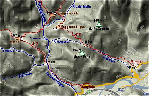
Map: Tabacco 018 (Canal del Ferro).
Getting There

Moggio Udinese
You can do the round tour in any direction, but the recommended start is Moggio Udinese, the parking place by the church (monastery San Gallo) in Moggio Alto, some 390 m. You reach the town by SS13 road, after exiting from Udine - Tarvision highway at Pontebba. From the south you get there from the highway exit at Gemona.
The small town of Moggio Udinese (in Slovenian: Mužac) is worth of a sightseeing tour. In the timest of Ancient Romans there was a settlement (castrum), or at least a watch tower. The first written documents are mentioning the town in the 11th century, in 1119 a Benediktine monastery was established. Despite of the 1976 earthquake, Moggio has preserved its charm. There you will perhaps first visit the abbey complex, rich in history and charm, then also the Medieval Tower (Prison Tower), which today hosts various art exhibitions and then do a stroll through its narrow streets.
Route Description
From the monastery in Moggio Udinese di Sopra you go towards the W-NW by Via Riu. At the end of the village you find inscription Moggessa di qua. After passing the last house the broad path enters the valley of Rio di Palis. It crosses the creek, continues up by the other side, and higher goes on the northern side again. in some 50 minutes you reach the saddle, 665 m.
On the other side the broad path is cut in steep slopes above Rio Moggessa. It is picturesque, descending all the time towards the NW. After 1 h 30 min (from the parking place) the nice, old path reaches the first houses of Moggessa di qua. It is worth sight seeing this small village, before you proceed.
 |
 |
In the village the marked path turns right and continues above Riu del Mulin in the N-NE direction. Ruins of an old mill which stopped operating in 1960-ies can be hardly seen, then you descend to the creek and cross it. The ascent to Moggessa di la takes another 15 minutes. Both villages are really picturesque, watching each other over a deep canyon.
 |
 |
 |
Also Moggessa di la is worth exploring. A very well marked path goes above the village (by the little church) - it crosses the slopes and later enters Torrente Glagno, following it several hours northwards, all the way to the saddle below Monte Sernio. Don't take that path, it's another tour, long, hardly done in one day!
Our path descends in the SW direction. In the lower part of the village you will find the inscription Stavoli - follow it. On Tabacco map this path is indicated as not marked, but you can follow rare red marks and the path is good. Across a nice grassy ridge you descend to the edge of the gorge, then the path turns down steeply and requires some care if slippery. You quickly lose altitude and the path brings you down to the place where Riu del Mulin flows into Torrente Glagno. The crossing of the latter creek is marked with ciarns. You go around the corner, some 50 meters downstream, where the path resumes. You will see a good red mark (arrow) showing where the path exits the valley (there's a ruined house a bit higher). But before attempting the ascent to Stavoli, consider taking a bath in the nearby nice pond. Or a relaxed sunbath!
 Crossing Torrente Glagno |
 Torrente Glagno ponds |
The ascent to Stavoli village will take you some 45 minutes. At first the path ascends in several turns, quite steeply in the SW direction, then it keeps just below a distinct ridge, going in the W direction. After reaching a (mostly) dry creek it crosses it and does a final ascent in several turns. Stavoli occupies a broad, grassy ridge. The village looks inhabited, you will see nice gardens nearby, but people are not keeping animals there, so they most likely make for living in the valley.
In the village you turn sharply left, following the marked path No. 417 (inscription: Campiolo). Over nice meadows the path passes a small church, then starts descending through the woods. A picturesque passage crosses a small ridge, then the path continues descending in several turns. It's a broad and well beaten mule track. In some 30 minutes it descends to Torrente Glagno again, you cross the creek by an iron bridge. You lost almost all altitude. The path accompanies the left bank of Torrente Glagno, you are still in a nice gorge.
 The church in Stavoli |
 Along Torrente Glagno |
After some time you reach the main railroad, but you see only a big tube exiting one slope of the gorge and immediately entering the other one. You ascend a bit, then continue through nice forrests away from the creek. In Campiolo you reach the asphalted road, by which you walk to Moggio.
Alternative Route
The round hike, described in this chapter, is less beautiful, but for it we can use bikes. We also visit both Moggessa villages, but before the hoke we prepare bikes in Badiuz hamlet, above Grauzaria village.
Description. From Moggio, 380 m, we go by Rio Palis westwards on the saddle, 665 m, and then further towards the NW down in Moggessa di qua. Then we continue by Riu del Mulin northwards. Just before the bridge, there is left below a decayed old moulin. Below it are nice ponds on the creek and further down a waterfall, which looks to be inpassable from above.
 Decayed moulin |
 Decayed moulin |
On the other side of the creek we continue in Moggessa di la, stroll through its houses and then continue towards the NE by the new, narrow mountain road. It crosses the slopes above Riu del Mulin. We ascend good 320 m and finally reach the Morôlz hamlet. Now we are on the meadows of long saddle between Monticello, 1362 m, on the east and Cimadors, 1639 m, on the northwest. Both summits can be quite nice objectives of a hike. From Morôlz, 855 m, we continue by the road, pass the renewed small church, reach Borgo di Mezzo, 832 m, and from there the nearby Badiuz, 838 m, where our bikes are waiting. The descent by narrow asphalted road is quick. Below we can ride also through the Grauzaria village, and then descend on the main road. To Moggio Udinese we have some 8 km of a slightly descending road.
Unusual wildlife
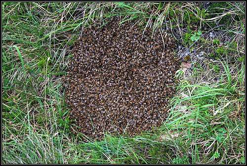 Bees |
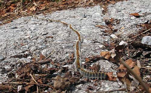 Caterpillars convoy |