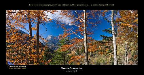
Monte Sernio and Creta Grauzaria. He and she. A beautiful pair of characters in the Central Carnic Alps. He is dominating this small group, monitoring over the broad territory around, she is a hard reachable beauty, all in fine towers and sharp ridges. Both mountains are leading a squadron of lower peaks, stretching like a tail towards the south. And a long and lonesome valley lies between the two.
Geology
The summit is made of dolomia principale, similarly as the neighbouring Monte Sernio, Zuc dal Boor and the stretch of mountains towards the mighty Montaž.
First ascent
Emilio Pico and Arturo Ferrucci with brothers Filaferro, on June 17th, 1893.
Geographical outline
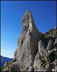
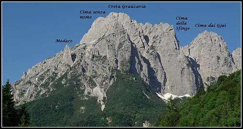
The narrow group of Creta Grauzaria consists of many wild summits and towers. North of the main summit stands the famous Cima della Sfinge, 1847 m. Its 650 m high northern wall is one of the most picturesque features of the whole group. The summit of Cima della Sfinge is connected with the main summit with a fine, sharp ridge. West of the big gorge, leading from the north to Portonat notch, the relatively independent Cima dai Gjai, 1916 m, stands. Finally, south of the main ridge the 1930 m high Cima Senza Nome stands. Actually on both sides of the steep valley, falling down towards the south from Portonat notch, a series of minor peaks stands.
What to do there?
Ascents on Creta Grauzaria are not easy from any side. The normal summit ascent is 200 meters of an UIAA II rock climb over the W face above Portonat notch. This nice cut in Grauzaria group can be reached either from the South or, more often, from the north. Around the narrow Grauzaria group, also a round marked path Arturo Ferrucci goes, on the southern part going by Cengle dal Bec (ledge). Even if it is marked, and on some places protected, it is more a climbing route than a path. Seen from the north, there should be very nice opportunities for hard climbing in Creta Grauzaria walls and towers. But I have no information about the importance of the mountain in this respect. Please add information if you have it! In the southern part of Creta Grauzaria group there's a remote area of rugged hills and deep, nice creeks cutting their way through them. There are a few villages which still until today have not the road connection to the rest of the world. Hiking through them is a nice experience.
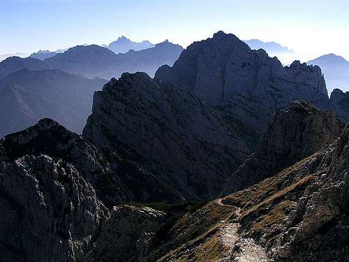
The panorama from Creta Grauzaria is great. But as the similar panorama was described on the page of the nearby standing Monte Sernio, I don't want to repeat the description here. Just the last sentence: "All in all, hundreds of peaks you have climbed are greeting you and hundreds of those you haven't climbed yet, are inviting you to visit them".
SW views
E views
N views
Getting There
Above Val Aupa
A self-made map of Carnic Alps
For the broader overview see the main Carnic Alps page and the Southern Carnic Alps GROUP page! As Monte Sernio, also Creta Grauzaria is a bit remote to the touristically developed world. Or may be also not so, because not so far away on the eastern side the Udine - Tarvisio highway runs. Even if also the western approaches from Incarojo valley, at the end of which Paularo lies, are not very long, the majority of visitors ascend on Creta Grauzaria from Val Aupa, lying on the eastern side of Grauzaria group.
Trailheads are listed in the Routes Overview chapter. From the south you enter Val Aupa at Moggio Udinese, lying close to the highway Udine - Tarvisio. From the north you reach Val Aupa from Pontebba (again by the highway Udine - Tarvisio), from where you drive towards the south over Sella di Cereschiatis (saddle), 1066 m.
Only one not hard climbing route is ascending the summit, the easy rock climb from Portonat notch, 1860 m, over the western summit rocks. UIAA II, marked, but not protected, 200 m, 30 min. In comparaison with Monte Sernio's normal (East) ascent, Creta Grauzaria's normal (West) ascent is about one UIAA step harder.
Portonat can be reached in 1 h 30 min from the north, from the Grauzaria hut by a marked path (No. 444), ascending through a steep gorge. From the parking place above Val Aupa valley you will need 3 h to Portonat notch.
From the south, Portonat notch can be reached either from Grauzaria village, 516 m, via La Forcje and the steep south valley to the notch (path No. 444), or from the remote villages Borgo di Mezzo, 832 m, and Morolz, 855 m, via Casera Cimadors, 1359 m (path No. 418a) and further to the notch by path No. 444. In all cases you will need some 3 h 30 min to 4 h to the notch.
The second marked path in the narrow Grauzaria group is the No. 446, which encircles the group, crossing its northern, eastern and southern slopes and then connects to the No. 444 path over Portonat notch. In the middle of this round path the Feruglio bivouac stands on 1700 m. It's a long partly secured path, with some easy alpinistic passages.
Summit ascent: Immediately above the Portonat notch you enter the summit rocks over the hardest climbing detail. A few meters high vertical step offers good rock to hold, but you are leaning a bit out of the wall, so the climb is rated UIAA II or UIAA II+ maximum. Exposition here is neglectable, so the step is easier psychically.
Above the first step a narrow ledge leads you towards the left. The exposition is rising quickly, but climbing itself does not exceed UIAA I degree. The route is well marked and goes again straight up and around the corner. In steep sections you gain altitude, crossing towards the left you approach the summit.
Soon the route goes around the next rocky ridge by another ledge, crosses the slopes towards the left again and so reaches the summit ridge. There it turns up directly, again climbs over a few harder details (not more difficult than UIAA II-) and finally over a quite exposed summit ridge reaches the highest point.
Harder Climbs
ganesh70> - Cima della Sfinge ( the sphinx ) and Cima dai Gjai ( the cocks' peak )
(Thanks to ganesh70, who added the following information): The Grauzaria group is very popular among climbers, because there are beautiful routes that can be climbed in almost anytime of the year. Here's a list of the most famous:
Creta Grauzaria
Via "Direttissima" - from the south crest of the east summit., diff. III/IV, 350 m.
From the south-west gorge, 350 m, diff. II.
Cima Senza Nome
From the south-west gorge of Creta Grauzaria, 200 m, diff. II
Via "Diretta Integrale" ( Via Bulfoni + spigolo De Infanti ), 700 m, diff. VII
On Cima della Sfinge there are also harder climbs (VII/VIII), opened by the famous climber from Tolmezzo Roberto Mazzilis.
Ski Tour
From Portonat notch towards the North also the ski descent is described. It is steep, but not exposed. If snow is very hard much care is needed, in soft snow conditions the tour is safe from sliding down, but there are higher risks of avalanche and falling rocks.
Creta Grauzaria can be climbed any time of the year, but as normal ascents require rock climbing, dry seasons are most recommended. In winter and early spring also the normal ascent would require a complete winter equipment - ice pick and crampons. But on the other hand the gorge, leading from the north to Portonat notch, can be easier to ascend in spring and early summer, when filled with snow.
Mountain Huts and Camping
ganesh70 - Bivacco FeruglioRif. Grauzaria, 1250 m. Stands in the valley of Rio Fontanaz, north of Creta Grauzaria. CAI sez. di Moggio Udiense, P.le G. Nais, 33015 Moggio Udinese, tel. 0433-51649. 20 beds. Tel.: 0433-51361. Access: From above Val Aupa (parking place on 727 m) by path No. 437 (1 h 15 min).
Casera del Mestri, 1512 m (in 2004 completely renewed). Stands in the valley north of Monte Sernio. Access from Paularo.
Bivacco Ferruglio, 1712 m. CAI di Udine, Soc. Alpina Friulana, via B. Odorico 3, 33100 Udine, tel. 0432-504290. 9 beds, permanently opened. Access: From Rif. Grauzaria by a secured marked path "Arturo Ferrucci", No. 446 (2 h).
Children refers to the set of objects that logically fall under a given object. For example, the
Aconcagua mountain page is a child of the 'Aconcagua Group' and the 'Seven Summits.' The
Aconcagua mountain itself has many routes, photos, and trip reports as children.
Parents refers to a larger category under which an object falls. For example, theAconcagua mountain page has the 'Aconcagua Group' and the 'Seven Summits' asparents and is a parent itself to many routes, photos, and Trip Reports.

 16782 Hits
 90.81% Score
 33 Votes
 Creta Grauzaria from the West, from the route on Monte Sernio
 ganesh70 - Needles
 ganesh70 - S face
 ganesh70 - W face
 Evening light
 Foran de la Gjaline
 SW views
 E views
 N views
 Above Val Aupa
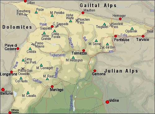 A self-made map of Carnic Alps
 Below the summit
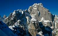 dante - The SE side with Cengle dal Bec