
|
|
Route |
|---|---|
|
|
42.63396°N / 0.88989°E |
|
|
Hiking, Mountaineering, Scrambling |
|
|
Summer, Fall |
|
|
Half a day |
|
|
Class 3 |
|
|
Scrambling and orientation |
|
|
I |
|
|
Overview
 From the Port de Caldès
Many routes lead to the Montardo, but one of them is very rarely described and very original.
This one, combined with a second route via the East of the Montardo (less original but also not very common) provides a very rewarding visit of this mountain.
Getting There
 Estany de Port de Caldès
To reach the starting point, we need to get first into the valley of Val d'Aran, at the village of Artiès where starts the asphalted road leading to Pont de Rius.
Artiès, near Vielha, is accessible from France via the exit of Montréjeau at the A64 motorway, or from Spain (sorry, Catalunya !), taking the direction of Montanuy from Lérida, then passing the tunnel to Vielha.
Agrandir le plan
Pont de Rius is the last asfalted point of the track, however it is possible to drive a bit further to get closer to the starting point, Pont de Loseron (near Pont de Ressec, and in the direction of Col de Prüedo).
There is no need to have a land rover, just a small car high enough on wheels, but there are good chances that this track is forbidden during the high season. In 2003 it was open to vehicles, but only during the autumn and the spring.
Route Description
 Lakes of Montcasau
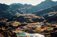
 Lakes of Ribereta
This route in fact is a loop, composed of 2 different ways to get to the Montardo.
There is a first approach via the East and the Port de Caldès, however not really a original route, but certainly more rewarding than the Restanca concerning proposed landscapes and panoramas.
Then, there is the N-E route whose aim of this page is to describe, which descends directly from the top to the starting point, via the lake of Sasloses. This route is described in the book of "Plus Beaux Lacs des Pyrénées" by Louis Audoubert, and I tried it in 2003. Following to this try, I sent an article to the "Revue Pyrénées", which was published in the number 230
For a first try, it is better to make them in this order, as the route is easier to find going down.
 Lakes of Colomers
 Port de Caldès
 Lake of Sasloses
 Basses de Montardo, NE route
1/ approach via the East (orange line on the map)
This route goes first via a well defined track for a few hundred meters, and becomes a single trail with the red marks of the GR11. It climbs to the lakes Estanhs de Montcasáu via a steep portion. The first lake is a dam, the second one is a natural one. Then, it heads to the pass Còlh de la Ribereta, just below the ridge of the Tuc de Salana, until we reach the two next lakes of Ribereta, Baish et Naut respectively (the "lower" and the "higher"), via a shy unmarked trail that leaves the GR11 on the right.
Circumvent the lakes on the left, walking on unstable rocky boulders.
Then we reach the pass Port de Caldès, where the view to the Cirque de Colomers appears, with all the lakes.
From this place, walk still a little bit until the pass to the West side of the ridge, where appears finally the Montardo, overlooking
Estanh des Mangades and Estanh des Monges. Descend in the direction of the lake Estanh de Port de Caldès, and walk along the Estanh des Mangades by the north shore.
When we reach the foot of the south ridge of the Montardo, it joins the normal route, heading to Col de Montardo. Then we reach the summit.
 Schema (from Tuc de Salana)
 Lake of Sasloses
2/ descent via the N-E (pink line on the map)
Below the ridge, on the north side, are lying two very small lakes, the "Basses de Montardo", occasionally named "Obaga" too. The descent starts here. Under the second lake starts a ravine, but we don't need to go in this direction. We need to walk to the East, following a large flat area, marked with scarce cairns.
Then it leads to a sort of small hollow that leads to two other very small lakes, the "Estanh del Agules del Port".
From here, the deep and wide lake of Sasloses, like a crater, appears below.
We have now almost finished the loop and there are now two options to get back to the starting point :
- Descend on the left shore via steep grassy slopes. In the place where the waters go away, is located a deep corrie with messy vegetation. With a bit of acrobatic skills, it is possible to climb down into it, and get back to the GR11 following the stream Arriu de Montcasau.
- Follow the very steep north side of the lake, without reaching the shores and staying on the high rocky slopes that overlook it. Circumvent as close as possible the south side of the Tuc de Sasloses, to get into the neighbouring corrie. This way, we reach back the Estanys de Montcasau, a bit higher, on the GR11 too.
 The N-E routes to the Montardo
Essential Gear
No essential gear is required during the high season, this is a typical hiking route, however with difficult orientation and wild terrain with occasional scrambles.In the spring, crampons may be required in few places, but it is not recommended at all to take the N-E route with more snow than few slices.
External Links
The page about my own trip to the Montardo, taking this route :http://h.visentin.free.fr/pyrenees/montardo.html