
-
 4274 Hits
-
 78.27% Score
-
 9 Votes
|
|
Route |
|---|---|
|
|
46.56267°N / 12.02500°E |
|
|
Download GPX » View Route on Map |
|
|
Hiking, Skiing |
|
|
Spring, Summer, Fall |
|
|
A long day |
|
|
Medium hard hike up (T4/T3)) |
|
|
Introduction

Tofana di Rozes from the ascent route
General Information

The section just below the notch is a bit unpleasant
Exposition: Exposed are only the last 50 meters of ascent, even if the slopes below our feet are nowhere really vertical.
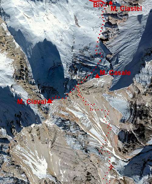
Orientation: Till the paths branching in Val Travenanzes the marks are very reliable. Further towards the Forcella Casale the marks on path No. 17 are weak and on those broad scree slopes we must choose carefully. On the main ridge there is only one right notch, but the slopes below the wrong ones also show some traces. See the GPX track (from Passo Falzarego) in the header!
Slope orientation: The slopes below the notch are south oriented. The summit slopes are north oriented. Be careful if snow lies on them!
Objective dangers: The route is objectively dangerous in the section just below Forcella Casale. The slopes are very friable, so rock fall is possible, especially if there are hikers above you.
Best season: Summer months, normally from July till October. In times of tour skiing till the Forcella Casale, or, depending on skills and with appropriate gear, even on top.
Gear: Good shoes and poles are sufficient. In times of tour skiing a complete winter equipment is needed (ice pick, crampons).
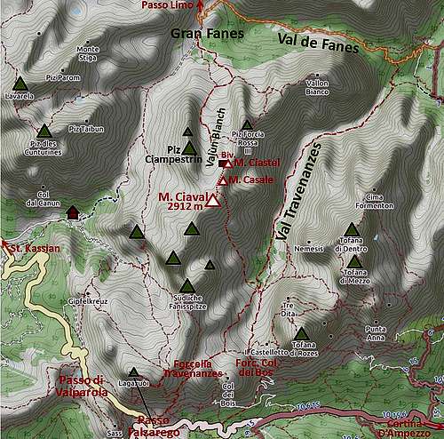
Tour start: There are two options: The first is Passo Falzarego, 2105 m, or Rif. Lagazuoi, 2752 m, reachable by cable way. The second option is the trailhead near Podestagno, on the road Cortina-Dobbiaco, ca. 1300 m.
Highest point: 2912 m.
Altitudes to overcome: Without using the Lagazuoi cable way, it's 1320 m up and 500 m down (on the return, you'll need to ascend those 500 m!). Using the Lagazuoi cable car, you only need to descend into Val Travenanzes, but the ascent is still there on the return. From Podestagno trailhead it's altogether 1720 m. From the paths branching it's 920 m to the top.
Times for ascent: From Podestagno you will need 6 hours altogether (3 h to the paths branching and 3 h to the top). From Passo Falzarego you will need some 5 h 15 min (only on foot) or 4 h 45 min (using Lagazuoi cable car).
Map: Tabacco. Cortina d'Ampezzo e Dolomiti Ampezzane. 1:25000.
Route Description

Red soil
1.b. Podestagno - paths branching in Val Travenanzes. You start the route by taking the mountain road to Gran Fanes. Only after Ponte Alto the path into Val Travenanzes branches left. Now almost the whole long valley is ahead of you and for altogether 700 m of altitude you'll certainly need 3 h, if not some more. On the ex Travenanzes pasture you keep right on the path No. 401, which then soon brings you to the branching (plate!).
2. Val Travenanzes - Monte Ciaval. The first part of ascent takes you through the woods in the W-NW directon. The path gains some altitude and then on some 2100 m turns right (northwards). We are now already close to the timber line, the path winds up over a rugged, with dwarf pines overgrown terrain and also crosses the slopes by some nice grassy bands. On some 2200 m the path slowly starts turning left, being well marked here. Over nice, grassy slopes we approach the big scree slopes, reaching them on some 2300 m. Now it will go in tedious switchbacks up. These are following a more solid terrain, while when descending we are shoosing of course the softest screes. On some 2560 m we keep right. We must reach a small saddle below the point 2587 m - that's an important orientation point, especially when descending. From the nice grassy saddle it's worth going to the nearby war post and up on the rock with great views on Tofana di Rozes.

Scree slopes

Scree slopes
On Forcella Casale we turn left and soon reach the base of Monte Ciaval. The final ascent goes up the northern slope in quite steep switchbacks. The path is just wide enough to walk up carefully, but on some places friable rock and exposition require additional attention. The turns bring us just below the summit. There the path disappears a bit and we need to carefully cross a few meters to the left, on the NE ridge. There's the mark and the remaining meters of ascent are an easy walk up again.
Descent. You can descend by the same route, or, if you are returning to Podestagno, can also descend by the north route and do a round tour. But in that case much more recommendable would be the opposite direction.