
|
|
Mountain/Rock |
|---|---|
|
|
49.00167°N / 113.85777°W |
|
|
Hiking, Mountaineering |
|
|
Summer |
|
|
8002 ft / 2439 m |
|
|
Overview
From the Waterton townsite if you look southeast across Upper Waterton Lake (the deepest lake in the Canadian Rockies at 148m/487 ft deep), you will see Mount Boswell. From the vantage point of the townsite “Bosy” (as Bob and Doug McKenzie types would surely call it) appears to have two peaks divided lower down on the mountain by a permanent snowfield angling north east up a valley. This 8000 foot mountain is pleasing to the eye making it a very inviting objective for mountaineers.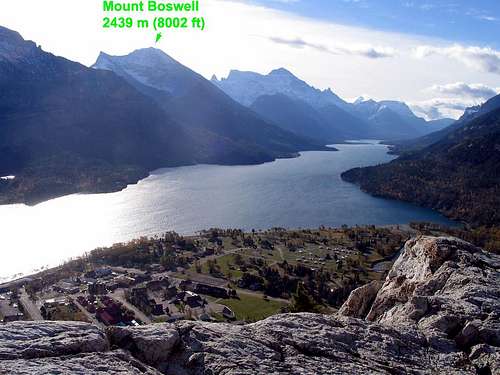
Looking southeast from Waterton Townsite area toward Mount Boswell.
Mount Boswell is located only about 1 km north of the Canada/US line, and is part of the Wilson Range. This peak was named in 1917 in honor of Dr. Boswell who was the veterinarian on the International Boundary Survey of the late 1800s. This mountain has also been known as Street Mountain in reference to Jack Street, friend of the infamous Kootenai Brown. Legend has it that Street and Brown used to run immigrants into the Canada via Upper Waterton Lake whose southernmost end crosses from Canada into the United States.
Getting There
Mount Boswell is located in Waterton Lakes National Park in Alberta, Canada. This Park is situated 270 km (162 miles) south of Calgary, Alberta, 43 km (27 miles) west of Cardston , Alberta , and about 80 km (48 miles) from the St. Mary entrance to Glacier National Park, Montana. When driving to Waterton Lakes National Park it can only be accessed from its eastern side.From Calgary take Highway 2 south to Fort Macleod, then west on Highway 3 to Pincher Creek, then south again on Highway 6. The drive requires about three hours.
From Cardston take Highway 5 west, through the village of Mountain View. The drive is less than 40 minutes.
From Glacier National Park, Montana, take the Chief Mountain International Highway (closed in the winter). From the St. Mary entrance of GNP it is approximately a 1 hour drive. In the winter take Montana Highway 89 to Alberta Highway 2 to Cardston, then Highway 5 to Waterton.
Once you arrive at the Park follow the entrance parkway (Highway 5) into the townsite, which is located 8 km (4.8 miles) down the road. En route, you will pass the famous Prince of Wales Hotel, about 1 km (0.6 miles) shy of the town.
Click here for a map.
Route
To climb this mountain you must first arrange to get to the other side of Upper Waterton Lake – adding to the both the adventure and appeal of tackling this striking peak. There is a dock on the east side of the lake at a place called Crypt Landing, so if you have your own boat you can anchor it there. Beginning in May and ending in October the Waterton Inter-Nation Shoreline Cruise Company (a family business) offers shuttle services across the lake from the Waterton Marina to Crypt Landing. The 2015 advertised price, for this 15 minute ride, is $22 per adult with shuttles leaving as early as 9:00 am and returning as late as 5:30 pm. Visit watertoncruise.com for the most up to date prices and schedule.Upon arriving at Crypt Landing the first four miles of the approach take advantage of the well-established Crypt Lake trail. For those unfamiliar with the Crypt lake trail, a quick Google search will soon bring you up to speed. As you start up the Crypt Lake trail you will initially be north of Mount Boswell, and soon you will be east of the mountain. In comparison from the townsite the view of Bosy is of its impressive west aspect. Once you leave the main trail you will be scrambling up Bosy’s east side.
Click here to see a photo displaying how Mount Boswell dominates the southern skyline along the Crypt Lake Trail.
At mile point 3.5, along the Crypt trail, you will encounter Burnt Rock Falls at which point you are going to need to begin studying the terrain to your right (west). Within another half mile you may notice a faint trail heading down to the west from the main trail. Follow that faint trail, which will soon peter out. As you descend into the Hellroaring Creek Valley from the main trail be sure to look up at Mount Boswell and notice the obvious gully that ascends the east face of Mount Boswell – this is the key to scramble to its summit. Leaving the main trail will find you having to bushwhack and shortly, at the base of the valley, you will need to cross a creek. Once you cross the creek begin the SW ascend up the aforementioned gully to the summit ridge. Upon gaining the ridge follow it southwest to a false summit and then due west to the true summit. Word of caution, if you are relying on the paid for boat shuttle to get back to Waterton Townsite the same day you likely will want to leave the peak no later than 2:15 pm.
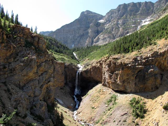  Above image is displayed from hikingwithbarry.com Boswell is visible above the falls (top/center of photo) |
See more helpful images of the Crypt Lake trail and Mount Boswell at enjoyyourparks.com.
Red Tape
You have to pay to enter the Park, and you have to pay to ride the boat shuttle across the lake.When to Climb
Late spring, all summer, and early fall, as those are the only times the lake shuttle boat operates.Camping
Parks Canada operates campgrounds in Waterton Lakes National Park. Click here for details.In the past backcountry camping was allowed at Crypt Landing, and near Crypt Lake. With time, and the increase popularity of the Crypt Lake hike this may have changed. Use the link above to enquire.
distressbark - May 6, 2015 1:15 am - Hasn't voted
typo re: boat shuttles"The 2015 advertised price, for this 15 minute ride, is $22 per adult with shuttles leaving as early as 9:00 am and returning as late as 5:30 am" I can only assume you meant 5:30pm? Hope this helps!
vanman798 - May 6, 2015 10:24 am - Hasn't voted
Re: typo re: boat shuttlesThanks for catching that. What I'm really impressed about is that someone (you) actually read the page!!! :)