

Comments
No comments posted yet.
|
|
Trip Report |
|---|---|
|
|
37.96720°N / 119.3192°W |
|
|
Aug 5, 2002 |
| Summary | Image Gallery | Trip Map |
|  Click Here
 | 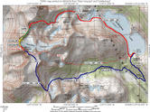 Click Here
 |
| |
| Selected Photos...
|
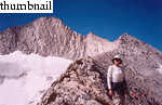
My watch broke a couple months ago, so I could only guesstimate the time of day by the sun's angle with the horizon. I figure we reached the start of the ridge by 09:30. By far the longest part of the ridge is the first part, an easy, somewhat exposed class 3 jaunt over boulders and scrub pines. This section probably required a mere half hour. For the sake of argument, let's assume that we reached the base of the so-called "first tower" by 10:00. We started climbing class 4 blocks, though in my case, quite gingerly, as I sported a 25-pound pack, full of our climbing gear. I'd have preferred a normal daypack, although since we'd been backpacking on our Mount Starr King trip, all we had were our internal frame packs.
Although the going is tough from here, the route technically does not start until one rappels from or downclimbs the "second tower". So we hoped not to have to rope up for a while. But as we approached the top of the first tower, we came to a 30-foot vertical section, with seemingly no alternatives to traverse. So we roped up and climbed. I found a wire gate carabiner with yellow tape. From the anchor, the climbing along the ridge looked tough, so we decided to traverse. By this time, Kim carried the pack, filled with our hiking boots, water, and food, while I carried the rack. We did a little downclimbing to the left side of the tower and started to traverse while simul-climbing. Kim got "gripped" at a couple points along the traverse: once when a large rock cut out from under her, another time when she came to a delicate move when she felt that the pack compromised her balance. In getting to this point, we'd wasted probably an hour and a half. In a sign of things to come, we free climbed the remaining traverse to the saddle between the first and second towers.
The second tower looks even more exposed and difficult along its crest than the first tower. Secor's advice is to "scramble" to the summit, and he gives no particular guidance, so we sought what we deemed the easiest route: up a scree-filled chute on the second tower's northwest slopes. Large rocks began moving as we clambored up the chute, so we stuck to climbing class 3-4 rock until we reached the summit of the tower. Although one trip report mentions that the rappel slings are 40 feet below the summit, we found good anchors just below the summit. A 60-foot rappel brings you to a ledge, from where the second rappel anchor is immediately visible. Aside from a brief scare with a mildly stuck rope, we were at Secor's "notch" between the second tower and the start of the route.
On the first two pitches, I fastidiously placed nuts and cams at the anchors. However, since time was running short and the setting and cleaning of the anchors was taking a long time, I changed my strategy to find solid flakes to which I anchor with a sling. Pitches 3-5 were climbed this way, and we were really moving by the time we hit the last one. I placed less and less pro on subsequent pitches, to reduce rope drag and speed things along. I started the sixth pitch high on the ridge. The fifth had been the most exposed pitch of them all, and I knew we were getting close to the summit. I had to gently traverse a large "chimney" between two towers, then climb up the west side of the highest tower. When I topped out, the other side was blank. I believe we were at the "blank section of 5.12X down climbing" mentioned in this trip report. I opted to downclimb about 30 feet of exposed, 5.4ish terrain.
Upon returning to the anchor, we decided to do a short (30-40 foot) rappel. From there, we traversed, and then free-soloed one last 60-foot pitch of west-facing rock to the ridge. Although the climbing was solid 4th class and harder in some spots, Kim bounded up the pitch with confidence and without a shred of reluctance. We had come a long way from the early portions of this climb, when we wanted the rope for every exposed move. Was it foolishness, confidence, or both? Regardless, freeing the sixth pitch saved us a crucial half-hour or so. However, I came very close to possibly profoundly regretting the decision, as a softball-sized rock careened down at me from forty feet. Were it not for a last-second shift of the left leg, that screamer would've done a job on my knee in the best case, and tossed me to the bottom of the west face in the worst case.
From the top of the sixth pitch, the last jaunt to the summit is a short, exhiliaratingly-exposed walk. I estimate that we topped out around 18:30, over nine hours after we started. Photos were taken, food belatedly eaten, and our short entry proudly squeezed into a full summit register. Amazingly, a party of two sauntered up the narrow East Ridge as we were preparing to leave.
Oops, I almost forgot the wind. From the moment we poked our heads onto the ridge at 09:30 to the moment we got down from the summit at 19:00, it blew. It always blew from the west and rarely had a speed of less than 30 mph. At times, I'd be unable to hear Kim talking to me from two feet away. As I'd belay, the snot from my nose would blow out in horizontal ribbons onto my glasses.
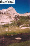
In my opinion, the initial descent from the saddle is the ugliest trail I've ever seen! Mercilessly beaten scree over slick granite boulders. Quite a bit of now-hard snow remained in the lower sections of the headwall. After clearing the initial jumbles, we expected an obvious, continuous use trail to pop out to us in the failing light. If anything, the trail became harder to follow the lower it went. As the light faded away for good, we found ourselves in a field of cliffs, permeated by the occasional impassible field of willow bushes. In short, not a fun place to be in the dark, particularly if you've never been there before.
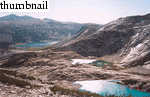
In our outdoor pursuits, I always ridiculously underestimate the time it will take to finish. However, this deluded demon must coexist in my mind with a pragmatic angel. The angel told me to take both headlamps, and made this non-negotiable. Otherwise we went very light. I knew we couldn't get lost; all we had to do was descend the drainage of the stream and we would eventually run into the Saddlebag Lake Road. Still, to save distance, I wanted to head left, hopefully for the dam. Soon after passing the cliff bands, we came to some fairly flat meadows, and eventually, to a well-worn trail. Unbeknownst to us at the time, the trail heads southeast, rather than northeast. Still, we preferred mindless slogging on a trail to cross-country travel at night. After a seemingly interminable walk along the trail, past the Saddlebag walk-in campground, we came to the road and slogged uphill for another mile to the truck. Time: 22:10. Car-to-car time: 15h,10m. Not exactly a speed record, but we were down, safe, and amazingly, incredibly satisfied at our accomplishment.