
-
 15979 Hits
-
 79.62% Score
-
 11 Votes
|
|
Mountain/Rock |
|---|---|
|
|
37.46965°N / 118.77771°W |
|
|
Mountaineering |
|
|
12405 ft / 3781 m |
|
|
Overview
Mount Huntington can be found out of Rock Creek up in the Hilton Lakes basin area sharing a ridge with Mount Stanford and eventually with Mount Morgan (North). This peak has routes ranging from class 2 to class 3 on the majority of routes.First ascent was on July 14, 1934 by David Brower, Norman Clyde, and Hervey Voge.
Getting There
If in the Mammoth/Bishop region, get on the 395 to Tom's Place and drive up Rock Creek Road to the Hilton Lakes / Davis Lake trail head. Head up the trail on the way to Hilton Creek Lakes. Follow this to the upper Hilton Creek Lakes all the way to Lake 10353. From here pick your route and head up.There is another approach from the west from either Pioneer Basin or the Fourth Recess. These can be easily reached out of Rock Creek after heading over Mono Pass then north towards the peak.
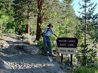 Trail head.
Red Tape
This climb is within the John Muir Wilderness, so any overnight stays will require a permit. Due to high traffic through this area, from May 1st to November 1st a quota system is in effect. 60% of permits can be reserved ahead of time with a $5 per person fee and the other 40% of permits available on a first come first served basis starting 11am the day before the trip.Bear canisters are required for overnight stay. In addition no campfires are allowed over 10,000ft.
More information can be found here.
Camping
Camping either at Lake 10353 or one of the other Hilton lakes is very accessible and might be a better alternative instead of the decent hike in and out. If going for primarily Mount Huntington, Lake 10353 is the closest. Though it also can be done in one day and even linked by traverse to Standford or even Morgan by a fit fast moving party. The link to Mount Standford is much more doable.Of course, camping is also possible on the west side in either Pioneer Basin or the Fourth Recess depending on the chosen ascent route.
Routes
Southwest Ridge: Class 2. First ascent July 14, 1934 by David Brower, Norman Clyde, and Hervey Voge. Ascend the ridge from Pioneer Basin.Northwest Ridge: Class 3. Descended July 14, 1934 by David Brower, Norman Clyde, and Hervey Voge. Traverse the Sierra crest from Mount Standford.
North Face and Northwest Ridge: Class 2. First ascent August 22, 1987 by Jerry Keating, Dick Agnos, and Elton Fletcher. Ascend the far right-hand (western) side of the north face almost to the crest of the northwest ridge. Traverse beneath the northwest ridge across the top of several loose chutes on the north face to the summit.
Northeast Ridge: Class 2-3. First ascent June 23, 1973 by Bill Schuler, Bill Sanders, and Ed Treacy. Climb a steep chute on the north side of the northeast ridge and follow the ridge to the summit.
All information in "Routes" section taken from The High Sierra: Peaks, Passes, and Trails by R.J. Secor.