A Second Attempt on Lamarck
Ruvicha and I set out about 8:00 am on August 14 to summit Mt Lamarck from the North Lake trailhead. We had attempted the route in 2010, with a third hiking partner, but turned back at about the half-way point … tired, in my case fighting a serious head cold, and severely discouraged by the appearance of a steep moraine slope that looked like anything but fun, with darkening clouds that suggested bad weather farther up. So we put Lamarck on our must-do list for this summer’s week in the Sierra.
![View from North Lake]() Looking Up from the North Lake Parking Lot
Looking Up from the North Lake Parking LotThe First Two Miles
We started from the North Lake parking lot (note: if you can get one of the walk-in camping sites directly at the trailhead, you can knock a half-mile each way off the hike). From the trailhead, the clearly marked sand trail rose consistently in a series of switchbacks through a pleasant pine forest after separating from the path to Piute Pass. We made good time and after a mile-and-a-half found ourselves looking down on Grass Lake. In another half-mile we reached the eastern shore of Lower Lamarck Lake, at about 10,600 feet (the trailhead was 9400 feet). With a bright sun and cloudless blue skies, the lake’s azure waters mirrored the mountains on the lake's northern side.
![Lamarck Trail]() Early Going on the Lamarck Trail
Early Going on the Lamarck Trail![Lower Lamarck Lake]() Lower Lamarck Lake
Lower Lamarck Lake![Lower Lamarck Lake]() Lower Lamarck Lake
Lower Lamarck Lake![Lower Lamarck Lake]() Lower Lamarck Lake
Lower Lamarck Lake![North of Lower Lamarck Lake]() North of Lower Lamarck Lake
North of Lower Lamarck LakePassing Lower Lamarck Lake
After proceeding a short distance along Lower Lamarck’s southern shore, the trail angled up, to the south and over a small ridge. From there, we walked down and found a place to cross the Lamarck Creek, which flows out of Lower Lamarck Lake. The simplest crossing was at the eastern end of a small pond on the creek, where two logs made for a handy bridge. The rocks that we had crossed the previous year were close to the logs but underwater, given the higher than usual creek flow due to the year’s high snowpack.
![Crossing Lamarck Creek]() Crossing Lamarck Creek (headed down)
Crossing Lamarck Creek (headed down)![Lamarck Trail]() Creekside Trail
Creekside Trail![Lamarck Creek]() Lamarck Creek
Lamarck CreekLeaving Lamarck Creek
Once across the pond, we found the trail again. It worked its way to the southwest and eventually along the creek linking Upper and Lower Lamarck Lakes. At about the midway point between the two lakes, the trail climbed up, away from the creek to the south and up the side of the ridge to the left.
![North and Grass Lakes]() Looking Down at North and Grass Lakes
Looking Down at North and Grass Lakes![View from Lamarck Trail]() View from Lamarck Trail
View from Lamarck TrailThe Dreaded Moraine Slop
Once over the ridge, we had great views to the south but were out of sight of Upper Lamarck Lake. This brought us to the three-mile point, about halfway to the summit of Lamarck. From there we caught sight of the dreaded moraine slope from the previous year and saw that the lower third was still snow-covered. The trail headed pretty much straight for the slope. (Note: check your trail carefully here; we found a clearly visible trail going up but, as noted below, lost it in this area on our return.) When we arrived at the bottom of the slope, we found a trail switchbacking up through the snow. We were able to skirt some of the snow and stay on sand and rock. The trail broke clear of the snow about a third of the way up, and the switchbacks moved to the left (south) of the moraine slope, not nearly as bad as it had looked. From here we were able to get a view of Upper Lamarck Lake to our north. The trail then angled around a ridge, where the path narrowed, with a sharp drop-off on the left side as we continued to gain elevation.
![Moraine Slope on Way to Lamarck]() First View of the Dreaded Moraine Slope
First View of the Dreaded Moraine Slope![Moraine Slope on Way to Lamarck]() Looking Up the Moraine Slope
Looking Up the Moraine Slope![Upper Lamarck Lake]() Upper Lamarck Lake
Upper Lamarck LakeApproach to Lamarck Col
As the trail crested a ridge, we found ourselves crossing a small treeless meadow and beginning to look up the slope toward the Lamarck Col, although neither the Col nor Mt Lamarck were immediately visible. We encountered plenty of sun-cupped snow, now well above 11,500 feet. There were plenty of ways to skirt the snow though, when we had no choice, crossing it posed little problem (the snow had been warming for hours in the morning sun). We encountered a couple of groups of hikers descending, having crossed over Lamarck Col from the backcountry to the west.
![Approach to Lamarck Col]() Approach to Lamarck Col
Approach to Lamarck ColVia the Col or Direct Ascent?
After a couple of more slopes, we could see the Col and Lamarck summit. A well-used trail worked its way up the snowbank leading to the Col, which lies about a quarter-mile south of the summit. We watched a couple of hikers gingerly descend the trail – understandably so, as a slip would have meant a 150-foot slide into the small icy lake directly below the Col.
![Approach to Lamarck Col]() Approach to Lamarck Col; First View of Lamarck Southeast Face (center right)
Approach to Lamarck Col; First View of Lamarck Southeast Face (center right)![Lamarck Col]() Lamarck Col (trail rising above lake on left)
Lamarck Col (trail rising above lake on left)![Lamarck Col]() Lamarck Col (viewed from part-way up Lamarck's southeast face)
Lamarck Col (viewed from part-way up Lamarck's southeast face)To the Summit
Not wanting to chance the swim, we elected to skip the Col, save some distance, and directly ascend the southeast face of Lamarck, which had some snow but also plenty of clear areas. The last quarter-mile – and 600 feet of elevation gain -- featured scree slogging before we gained altitude and found larger rocks to scramble up. By 2:00 pm we attained the summit plateau and found and signed the register. (We were the only two to sign the register that day, unless someone summited after 2:30 pm; the traffic that we encountered on the trail was heading to or from the Col, not the mountain.)
![Southeast Face of Lamarck]() Lamarck Southeast Face
Lamarck Southeast Face ![Atop Lamarck]() Atop Lamarck
Atop Lamarck![Atop Lamarck]() Ruvicha Atop Lamarck
Ruvicha Atop LamarckSummit Views
The Lamarck summit offered stunning views in all directions: Mt Darwin and Mt Mendel to the south; Wishbone, Upper Lamarck, Lower Lamarck, Grass and North Lakes to the east (with Bishop in the far distance); Mt Emerson and Mt Basin to the north; and all kinds of mountains to the west. A stiff cool wind, however, kept us from lingering, and we headed back down about 2:30 pm, quickly descending the southeast face. (There was also a cool breeze during our aborted 2010 attempt – take some layers if you wish to comfortably spend time soaking in views on the summit.)
![View from Mt Lamarck]() Looking toward Bishop
Looking toward Bishop![Darwin and Mendel from Lamarck Summit]() Darwin and Mendel
Darwin and Mendel![View from Mt Lamarck]() View to the North
View to the North![View from Lamarck Summit]() View to the South
View to the South![View from Mt Lamarck]() View to the South
View to the SouthHeading Down
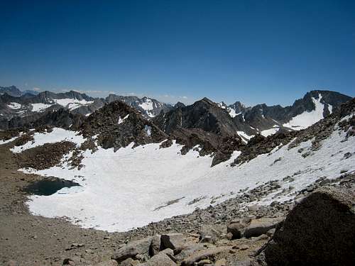
We made good time heading down below the summit until we had one of those “uh-oh” moments. We came up on a beautiful view of Upper Lamarck Lake. The only problem was that we were viewing the lake end-on – we were heading directly for the lake rather than back down the normal path from the Col. We retraced our steps, hiking back up a couple of hundred feet, and moved south to regain the path which we had followed up.
![Upper Lamarck Lake]() If you see this view of Upper Lamarck Lake, you are off route
If you see this view of Upper Lamarck Lake, you are off routeCompleting the Return
We continued downward, crossing some snow before again reaching the trail. Once below the moraine slope, however, we again found ourselves off route. I’m not sure how we missed the trail, which seemed very clear on the way up. After a bit of searching, we climbed up on the ridge, from which we could see the creek linking Upper and Lower Lamarck Lakes and the creekside trail. After some more fruitless searching for a trail down, we decided to work our way down a cliff of jagged slate to the creek and trail below. Once on the trail again, it was a straightforward hike back to the trailhead and North Lake, though we had to swat away the evening mosquitoes.
A Great Hike!
Ruvicha and I took about ten hours to summit Lamarck and return, but we aren’t particularly fast and expect others would likely complete it more quickly. At 12 miles roundtrip and 4000 feet elevation gain, the hike was fun and challenging at spots, provided great views, and offered some easy climbing – as in equal use of hands and feet – with manageable exposure vice just hiking. We found Lamarck a thoroughly rewarding day-hike and highly recommend it.


Comments
Post a Comment