
-
 39368 Hits
-
 77.47% Score
-
 8 Votes
|
|
Mountain/Rock |
|---|---|
|
|
37.19500°N / 118.67°W |
|
|
13417 ft / 4090 m |
|
|
Overview
Mount Lamarck lies on the crest of the High Sierra about 1 1/2 miles north of Mount Darwin. While easily climbed from the cross country trail over Lamarck Col ( class 2 ), Mount Lamarck also has a moderate ice gully on the North Face which provides excellent snow and ice climbing. The South Slope and Southeast Slope are also class 2.
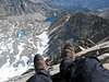
Mount Lamarck has an excellent view of Mounts Darwin and Mendel!
 |  |  |  |  |
Getting There
Take Highway 168 from Bishop, CA. Follow the road to the North Lake trail head. Take the Lamarck Lake trail to Lower lamarck Lake. To climb the ice gully on the North Face, continue to Upper Lamack Lake. From here, rock hopping up the moraine past a glacial tarn leads to the pocket glacier at the base of the North Face.
For the class 2 route from Lamarck Col, leave the Lamarck Lakes trail between the Lower and Upper Lakes and head southwest along a faint path ( see R. J. Secors The High Sierra, Peaks, Passes and Trails guide book ).
The maps for this area are the Mt. Darwin and Mt. Thompson 7.5 minute USGS quadrangles.
Red Tape
Wilderness permits are required for overnight camping. There is a wilderness permit quota in effect from May 1st to November 1st. 60% of the wilderness permit quota is advance reservation ( $5.00 per person ) and 40% is available on a walk in first come first serve basis ( free ). See the Inyo National Forest website at http://www.r5.fs.fed.us/inyo/ for the most current information.
Inyo National Forest - Wilderness Permit Office - 873 North Main Street, Bishop, CA 93514
Reservation Line - 760 - 873 - 2483
Wilderness Permit Fax Line 760 - 873 - 2484
Wilderness Information - 760 - 873 - 2485
When To Climb
The best time for climbing Mount Lamarck is generally June - October.
Camping
Excellent camping sites can be found at Upper Lamarck Lake. There are also several campsites at the end of the road at North Lake ( fee required ). Wilderness permits are required for overnight camping - see the Red Tape section above.
 |
Mountain Conditions
The most current information can be found at the Inyo National Forest website at http://www.r5.fs.fed.us/inyo/. The website www.395.com is another good resource.
External Links
- Eastern Sierra Webpage
Good information on the eastern High Sierra
- WWW.395.COM
Good information on the eastern High Sierra region
- Inyo National Forest Website
Current Forest Servive information and wilderness permit information
- Mt Lamarck - July 2002
- A visit to Evolution Valley - Sept 11, 1994
- My photos of our trip to Mount Lamarck
Pictures of the trip from North Lake, Lamarck Lakes, Lamarck Col and Mount Lamarck.
- My trip to Mount Lamarck
- Muriel/Goethe/Lamarck dayhike - Aug 12, 2004
schmed - Sep 24, 2011 11:27 pm - Hasn't voted
NW LamarckHi There, I'd really like to move information from my existing “Northwest Lamarck” page to this page, and then delete my page. I don't think it really makes sense for them to be separate given the proximity of these two summits. Perhaps it might be sufficient to include one section labeled “Northwest Lamarck” on this page? Please let me know what your thoughts are on the matter. Thanks, - Chris
Craig Peer - Sep 25, 2011 5:18 pm - Hasn't voted
Re: NW LamarckSure - ask a moderator the best way to do this. Craig
Bob Sihler - Nov 4, 2013 11:47 am - Hasn't voted
Re: NW LamarckAs page owner, you can simply create a new section on the page and copy over whatever Schmed wants. I can do this as well if you're too busy but prefer to ask before going and messing with people's pages. Alternately, I could adopt this page if you're no longer interested in maintaining it. I climbed the peak last summer and could add some route details from the col and also update information about the trailhead, which is a pain to access unless you can snag a campsite at road's end.
Alpineskier7 - May 7, 2022 10:42 am - Hasn't voted
Mt Lamarck from Lamarck ColGreetings fellow mountaineers. I remember climbing this peak when I was in Troop 276 aka “The Mountain Men” from Palos Verdes Estates, CA back in August, 1977. I was 15 back then and a Star Scout. It was towards the end of our 8 day long term Sierra hike where we started backpacking from the Pine Creek trailhead and ended at North Lake, approx 75 miles total, half of the hike was cross country travel, part of it was on the John Muir Trail. What made this backpack trip very challenging was to go over several cross country passes, particularly Lamarck Col, with heavy external frame packs. The route we used started in Darwin Canyon, we scrambled up class 2 talus on the South side of Lamarck Col at approx 12,900 feet. From Lamarck Col we climbed up easy class 2 talus up the SSE ridge to the wide summit plateau, the true summit was further to the north. This was the first peak I climbed doing the sport of mountaineering off trail, I didn’t know what mountaineering was back then. I would rate this climb 4 out of 5 stars as it is a nice short scramble up the SSE ridge on stable class 2 talus and bracing and great views on the summit plateau; also it is an excellent 13,000 foot peak for beginning mountaineers to climb. The photos already posted (any that were shot from Darwin Canyon and the SE Ridge are helpful, there are over 100 photos) might be the best bet to document this particular route. Hopefully, I can find some photos, wait and see!