
|
|
Mountain/Rock |
|---|---|
|
|
37.11790°N / 118.5164°W |
|
|
12967 ft / 3952 m |
|
|
Overview
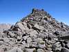
Mount Robinson is located just north of the prominent palisade peaks which are the envy of many a California mountaineer. Robinson is easily seen from the frequently traveled N. Fork of Big Pine Creek trail and camping spots near the Palisade Glacier. Even though there are relatively easy routes on Mt. Robinson, because it is located amongst other more popular mountains (including five fourteeners) it is seldom climbed. Yet for those who endure the long approach across infrequently visited areas of the Inyo wilderness, the summit of Robinson offers spectacular views of the Palisades to the south and Sam Mack Lake to the East.
 |  |  |
Approach and Routes
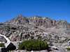
Mt. Robinson generally can be approached from either the Bishop Pass or the North Fork of Big Pine Creek trailheads. If following up the N. Fork, stay the trail to Sam Mack Meadow at which point split off and follow up to Sam Mack Lake; here one can ascend the class 2 SE slope. If coming from the north (Bishop Pass), one must gain Agassiz Col and traverse around Mt. Agassiz to reach the base of Mt. Robinson. This puts one in position to climb the more difficult west ridge.
Alternatively, if climbing other prominent peaks which line the area, Mt. Robinson can also be approached from a base camp near the Palisade glacier. The route leads one along the rarely traveled East sides of Mnts Winchell and Agassiz and offers great views of the glacier lakes and streams.
Some routes are outlined in the following table:
| route | first ascent | brief info |
| NE Face | Class 3 | First ascent by Norman Clyde in 1930 |
| W Ridge | Class 3 | First ascent by Brower & Voge in 1934. route finding makes it very difficult to maintain class 3 along the ridge; be prepared for class 4 and possibly mid class 5 climbing to reach the summit. |
| South Face | 5.7 | First ascent by Roper, Clark, Lonne, & James in '68. This route follows one of the aretes on the south side; for more info see Secor. |
| SE | Class 3 | Descended by Brower & Voge. To climb, you can follow any of the chutes on the SE side. Many of them look like nice class 3 fun. |
The easiest routes on this mountains are the SE slopes and the NE face. The long ramping west ridge looks quite inviting and Secor rates it as class 3; yet in reality one would have a difficult time climbing this ridge and keeping it to class 3 as there are many sections along the ridge that are strict class 4 moves. Mid class 5 rock routes also exists on both the north and south sides of the mountain. For more detailed information on the established routes up Robinson refer to Secor's High Sierra Peaks Passes and Trails).
 |  |
Red Tape
All over night traffic in both the Inyo Nation Forest and Kings Canyon National Park require a wilderness permit. Permits are reseravable in advance from both the Lone Pine and Bishop Ranger stations. The current cost is $5 per person for any number of nights. Walk in permits (if available) are free; day hikers/climbers require no permit. If going in winter, one can self issue a permit at either Ranger station prior to entering the wilderness. There are plenty of hungry marmots in the area. Bring a canister or make sure to properly store your food by hanging it in a tree.
When To Climb
Robinson, if climbed at all, is typically ascended in the summer and fall months. If attempting in the winter, this would make for a fun multi day alpine excursion.
Camping
Wilderness camping is only allowed with a valid permit. There are some nice camping spots near Sam Mack Meadow and others at the base of the Palisade Glacier. If wanting to camp closer to the west ridge, be aware this area can be very windy and currently there are no nice stacked rock shelters to protect tents from the wind.
Mountain Conditions
Current condtions of all of Inyo Nation Forest may be attained by calling the Ranger station at (760) 873-2400.