

-
 20043 Hits
-
 74.92% Score
-
 5 Votes
|
|
Mountain/Rock |
|---|---|
|
|
0.08085°S / 77.65823°W |
|
|
Hiking |
|
|
Spring, Summer, Fall, Winter |
|
|
11686 ft / 3562 m |
|
|
Overview
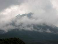
El Reventador is an active volcano in northern Ecuador which displays explosive and effusive behaviour (lava flows). The name itself 'El Reventador' is indicative as it translates as 'The Exploder'. Activity is currently centered at a 1300 m tall strato-cone that has grown within a 4 kilometre wide caldera, a relic of a pre-historic sector collapse (visible in the below map). For a great overview photo see this external picture. While well east of the main axis of the Cordillera Oriental, it remains the most active of any volcano of that range. When quiet when there is solely effusive activity, it may be relatively safely climbed, though not necessarily to the summit in the latter case. It is not a popular peak to attempt, due to its relative remoteness, volcanic hazard and the lack of obvious means of access (much of the journey is spent wandering in jungle and then scrambling over old lava flows and mud). There are several possible routes referenced here, each visiting a different part of the caldera prior to heading up the cone proper. Summiting would require ~ 6 hour hike from the trailhead, or 4 hours if camped inside the caldera. Expect rain and eruptions any time of year. The largest eruption at Reventador in recent times was in 2002 when after a 19 year quiescence a huge eruption produced a 17 km cloud visible from Quito, pyroclastic flows and lahars that travelled many kms and damaged roads and an oil pipeline. Many of the photos here were submitted by others so thanks to them for helping illustrate this amazing place. Thanks also to chris_2112 for starting this page.
View Larger Map (if no image above, right-click area and refresh)
Getting There
Take a bus from Quito (leaves 7 am, ~$10, 5 hours) or drive down (3-4 hours) the Quito-Lago Agrio road to the San Rafael Waterfall. Take your passport as you'll be crossing a checkpoint along the way and have your ID checked. If taking the bus buy a ticket to 'El Reventador' town, but ask to be dropped off at 'Hostería El Reventador' which is by the waterfall. Don't rely on the bus driver remembering where you want to be dropped off so know you're close when you see a a sign saying 'Rio Salado', cross an obvious pyroclastic flow deposit then spot a big river scarp on the other side of the river. It's a bit hard to see the waterfall from the bus. Also feel free to ask people what town you're in at any time as signs are rare.Buses back go past the hostería around 10 AM but you'll want to check this info at with them before relying on it.
 Reventador Reventador |
 San Rafael San Rafael |
 Trailhead Trailhead |
Routes
Given that Reventador's activity changes regularly where you can go and where you'll want to go will change regularly. The original page author chris_2112 went to a different part than I did so there are two sections here, the first most of the way up the cone to see an active lava flow front, and the second to the summit, though it is rather vague. Also see the attached Trip Report for another route choice. A note on footwear: Wellington/rubber-boots are pretty essential if the weather is wet as the terrain will be very muddy and boggy. Unless you have pretty hardcore gaiters you'll want these and as the access route itself isn't technical it's not a big deal for the most part. You can get these from Hostería El Reventador / a guide service (see below) if you don't have your own. Umbrellas are also nice.Current route info (by Baarb):
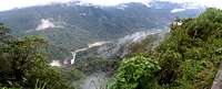
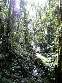
Getting into the caldera (2 hours): The route begins 2 miles NE up the road from Hostería El Reventador (1400 m) just over a bridge at 1600 m. Heading straight into the jungle there's a path which heads somewhat steeply upward past waterfalls and partially along a small stream (40 mins). You come out onto a relatively flat and open area which will be pretty boggy if it's been raining. Go through the barbed wire fences till you come across a tree covered hill (20 mins). There's a very specific opening in these trees where the path starts which is why going by yourself isn't a wise move. Continue along the regularly twisting and double-backing path which seems barely visible at times unless you know where it is. All you can see is green, there is no edge to the jungle it seems (40 mins). Eventually you'll hit the caldera rim and start heading down again and catch fleeting glimpses of the caldera interior and a lava flow snaking down out of the mist. Finally you'll make it out of the trees onto a carpet of mosses that cover every patch of ground a rock. (20 mins).
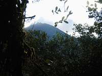
Getting up the cone (3.5 hours): Hike west and cross the channel the lava flow was coming down then following along its edge till you get to where it meets the bank. This is a good spot for camping as you can dry stuff by the steam vents on the lava flow and leave a lot of your gear here while going higher. Altitude here is ~2200 m. Clamber onto the lava flow and carefully go along for ~ 200 m distance till you can drop back down again. Keep going keeping the lava flow on your right. Around 2800 m you'll start walking on potentially very slippery mud and moss covered ground so be careful here. Presumably you can take this route all the way to the top, but personally only went to 3100 m as we were interested in the lava flow front that was there at the time. Take the same route all the way back, making sure to stick close to the same flow on the way up else you'll end up on a plant covered old flow that makes for very slow going owing to the amount of times your legs will disappear down invisible holes. Photo sequence below of the general route below.
 Rio Reventador Rio Reventador |
 Winding paths Winding paths |
 Into the jungle Into the jungle |
 Almost there Almost there |
 Into the open Into the open |
 Caldera floor Caldera floor |
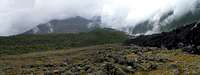 Reventador cone Reventador cone |
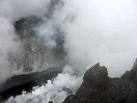
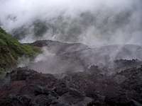 Steaming lava Steaming lava |
 Route ahead Route ahead |
 Flowing lava Flowing lava |
  |
Previous route info (by chris_2112): The trail to the base of the mountain begins about a mile up the road from Hostería El Reventador and is marked (Cayambe-Coco National Park), but following the trail will be VERY difficult without a guide. The hike to the base of the cone takes 4 hours through dense jungle, but you experience little net relief change (lots of ups and downs though) and the trail is in okay shape. A machete is not required, but useful. A camping area is obvious at the end of the trail, and is a good place to stop and spend the night for an early ascent the following morning. The trail to the summit starts to the north of a thick old lava flow, and proceeds up an old lahar bed. You can't really miss it. Photo sequence below.
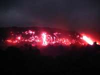 Incandescence Incandescence |
 Hot ash fall Hot ash fall |
 Active lava Active lava |
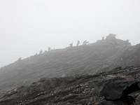 Paramilitary types Paramilitary types |
 Summit crater Summit crater |
Video of crater area by yotubyron.
Speculative route info (by Baarb): Judging by this external picture of the caldera and the road down below, it might be possible to simply climb up the pyroclastic flow deposit snaking its way down on the left-hand side. Given that it actually meets the road, following it up should in theory be pretty straight forward. Saves getting lost in the jungle at least but then again the more vegetation there is the less the volcanic hazard given that it's still there.
Guides / Camping / Accomodation
Guide and equipment rental information: (via jplemarie)It is possible to hire tents, sleeping bags and cooking stuff with Victor A. Cansino, so you don’t have to carry that weight. He lives down from the Hosteria, his house it has a satellite dish. He works for the hydro-project company but he can make some time to guide you for $40 per day. This is his new mobile number (593) 09 7677176 it is on the Claro network, there is no Movistar signal at the Hosteria. The email address turismovolcanreventador@yahoo.com may still work.
Again, this will be a very difficult experience indeed without a guide or someone else's GPS track, 99% chance you will get lost. At least take a map and a sat phone. The adjoined trip report contains some GPS information which may help general progress towards the cone but unless you're on the exact fairly invisible path you're going to have a hard time regardless.
Camping: Depending on your ambition there is no need to camp on the mountain, as the return trip to the caldera floor is doable in a few hours. However if you want to climb up on the cone you'll want to camp at its base within the caldera where there are large open areas, but no huts or refuges exist (contrary to some guide book information, presumably they were destroyed in 2002). Remember it rains a lot so bring something good.
Accommodation: Hostería El Reventador in San Rafael - a good place to stay while in the area, has many reasonably priced rooms (~ $12 US), private bathrooms, a restaurant, several pools fed by mountain streams etc. A variety of guided tours are available from here. Phone number: 09-312-9515 (or 09-758-2198?).
Supplies: Water on the mountain is limited to a few places, the only one I know being quite close to the trail head but there are some others mentioned in the attached trip report. Just depends where on the mountain you're going I suppose. I don't know if the water's good to drink given potential metal or chemical content from the volcano. Best to get all food you need from a town en route unless you want to try making arrangements ahead.
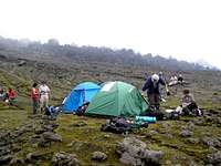 Camp wherever Camp wherever |
 Hostería Hostería |
When to climb, weather and volcanic activity
It's better to climb in the dry season of the January-March months, but can be climbed at any time. Climbing during the wet season means a lot more cloud, lower visibility, rain, mud, time hiking and difficulty climbing up the cone which will be pretty damn slippery. Also remember that you are on the equator here so you only get daylight from ~ 6 AM to 6 PM. Unless you have the mother of all headlamps you do not want to be wandering around in the dark. Temperatures are cool year round given the altitude you're at.Safety wise the climb is determined by eruptive activity, more than the season, but given the beauty of the place and presumed intent on seeing some small explosions or moving lava, the dry season is your best bet. There is no red tape at present, though there probably would be in the case of huge explosions or the likelihood of them.
You should check current activity with the Geophysical Institute in Quito before going to see if you're allowed and what there is to see when you're there. You should have a good idea about that so you know where to head to with / without your guide.
(Check the index of monthly reports for photos and descriptions of dramatic recent activity, particularly 2002).Instituto Geofisico Escuela Polytechnica Nacional (See "Informes volcánicos")
Global Volcanism Program page