Overview
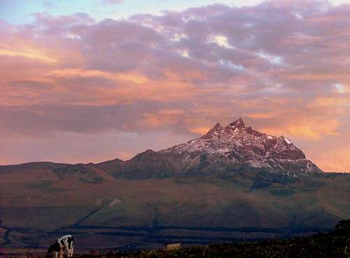
![Sunset on Sincholagua.]() Sincholagua (4,899 m / 16,073 ft) as seen from village of El Pedregal.
Sincholagua (4,899 m / 16,073 ft) as seen from village of El Pedregal. is the twelfth highest peak in Ecuador and one of the less visited due to its proximity to
Cotopaxi (5,897 m / 19,347 ft) which is the second highest volcano in Ecuador and the most popular. It was ascended for first time by Edward Whymper and the Carrels in 1880, one of Whymper’s very first climbs in Ecuador.Its name comes from the indigenous language, Sinchijajua, which more or less means “steep upwards”.
Sincholagua along with
Rumiñahui,
Pasochoa,
Morurcu and
Quilindaña forms part of the long range of eroded and extinct volcanoes that surrounds Volcan Cotopaxi and the Eastern Cordillera de Los Andes. It is a sharp pointy peak, regularly covered by thick mist and clouds, and occasionally covered by a thin layer of snow or hail.It is located 17 km north of Cotopaxi and 45 km southeast of Quito from where it can be seen in a clear day right outside the National Park’s boundaries, towering up right in front of volcan Cotopaxi.Sincholagua lost its glacier a couple decades ago, but sprinkles of snow and temporal snow fields can cover its flanks, especially after a heavy snowstorm which occurs very often on this peak.4,899m/16,073Views from Sincholagua of the surrounding mountains such as Cotopaxi and Antisana are stunning as well as of the Western Cordillera and the Amazon Jungle to the East.
Getting There
![Approaching to Sincholagua.]() Track to Sincholagua.
Track to Sincholagua.Enter
Cotopaxi National Park by the Park Ranger’s north control and head left as soon as you cross the gate. Drive for about 10 minutes on a dirt road until it splits in two. Take the left road heading north for about three km until it reaches a gate and a stream. Continue on this road for about 5 minutes to the southern shores of Rio Pita. There’s a gate there, which is usually locked (it’s advisable to get the key ahead of time at Tambopaxi lodge or Chilcabamba lodges). Follow the unmarked track on Sincholagua’s foothills up to a survey marker at 4,000 m (13,120 ft) and a radio transmission antenna. This track will take you as high as Sincholagua’s southwestern ridge at 4,350 m (14,268 ft). High clearance, dirt bikes or 4WD SUV’s only.In the event of finding the bridge gate locked, continue up on foot from the river (about 3 hours) following the same track or straight up through the grasslands to the survey marker.
Climbing Sincholagua
(4,899m /16,073 ft)Try to start as early as possible in order to take advantage of the frozen scree and compacted rotten rock. It is always good to avoid the afternoon stormy weather which is very common in Sincholagua.After leaving camp, follow the flat ridgeline located on the western flanks of the peak, until getting to the very base of the mountain. There are cairns everywhere, but try to follow those heading to your left side (north). The normal route continues up from time to time until it contours the mountain northbound reaching a steep ridge.
![Sincholagua s Direct Route.]() Sincholagua. Western Direct Route. The normal route starts at the base and goes behind the small spire on the left. The summit is reached from behind.
Sincholagua. Western Direct Route. The normal route starts at the base and goes behind the small spire on the left. The summit is reached from behind.Follow the ridge until getting to a sub summit, located at the northwestern side of the mountain. The route is well cairned here and drops down behind this false summit where it reaches a small scree or snow-filled basin right at the bottom of the main summit.You’ll see a steep scree gulley at your left side (20 m. Class 4). Scramble it up until getting to a sharp flat ridge and finally to the summit. The descent can be done by placing a webbing as an anchor on the top and rappelling down to the basin.It takes about three and a half hours to reach the summit from the camping site if the weather conditions are ideal.
Camping
![Sincholagua camping spot.]() Camping spot.
Camping spot.Camping is allowed anywhere in Sincholagua, but the best spots are located just 100 meters north of the survey marker (in case of thunderstorms) or at the end of the track, right where the flat ridge starts at 4,350 m.
Red Tape
No fees to enter into Cotopaxi National Park.Water is hard to find near the camping spots. The best option is to get water before the hike in Rio Pita (bridge).Be aware of cattle, they tend to chase hikers mostly when they are alone.
Transport
Buses to the town of Machachi (Mejia or Carlos Brito) leave from Terminal Quitumbe, south of Quito every 10 minutes. (USD. 0,75 / 1:15 h).Pick up trucks can be hired at the main square in Machachi (USD. 25,00 / 1:15 h) One way.There’s a bus Company (Machacheñas). They offer their services to Machachi – Pedregal – Loreto. Buses depart every 2 hours. This is a good option if you choose to save a few dollars or if you find yourself in the town of
Loreto or
El Pedregal, after descending by Sincholagua’s western flanks. (USD. 0,75 / 1:15 h).
Miscellaneous Info
GuidebooksEcuador, Climbing & Hiking Guide – Viva Publishing Network. (6th Edition)Rob Rachowiecki, Mark Thurber. 2008.
Other InformationMontañas Del Ecuador – Dinediciones.Marco Cruz. 2000.
MapsIGM 1:50,000 Sincholagua topographic maps are available at Instituto Geografico Militar (IGM) in Quito, and must be bought personally. Instituto Geografico Militar (IGM).Senierges y Gral. Paz y MiñoSector El Dorado.

 23053 Hits
 92.04% Score
 37 Votes
 Sincholagua (4,899 m / 16,073 ft) as seen from village of El Pedregal.
 Track to Sincholagua.
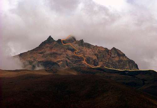 Sincholagua. Western Direct Route. The normal route starts at the base and goes behind the small spire on the left. The summit is reached from behind.
 Camping spot.
chugach mtn boy - Feb 11, 2023 9:07 pm - Voted 10/10
ElevationRecent sources generally put the elevation of the highest summit at 4899m/16,073 feet.
Boriss Andean - Feb 15, 2023 8:00 pm - Hasn't voted
Re: ElevationJust updated it. Thanks!