
|
|
Mountain/Rock |
|---|---|
|
|
41.14921°N / 120.12674°W |
|
|
Lassen |
|
|
Hiking |
|
|
Spring, Summer |
|
|
8737 ft / 2663 m |
|
|
Overview
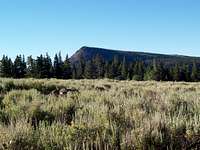
Hat Mountain is a classic fault block peak with a steep eastern face and a gentle slope to the west. It has a surface of volcanic rock overlaying older sedimentary beds. Sage brush is the dominate plant life on the summit plateau with stands of aspen while the lower slopes are covered with Jeffrey pine and white fir.
The views from Hat Mountain are expansive. To the west is the Modoc Plateau and the sentinel of Northern California, Mount Shasta. Lassen Peak can be seen to the southwest while Eagle Peak and the rest of the Warner Mountains lie to the north. To the east is the Surprise Valley and the range and basins of the Great Basin. To the south, the tablelands of Hat Mountain merge with Red Rock Mountains
Getting There

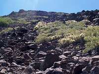
To get to the peak you can set off cross country through the sage (as I did) or follow the worsening road you were on until it comes to a ravine and follow the faint trail along a very small stream to the north shore of Lost Lake. From the south side of Lost Lake head off south, cross country (there are no trails to the summit) through the forest until you come out to the open plateau, turn east and hop rocks and wade through sage to your destination. Another option from Lost Lake is to move to you left through the forest to find a large boulder slope and rock hop your way to the summit.
There is a rough 4WD jeep road to Lost Lake from the east, but not having traveled it will not attempt to give mileage or directions.
Red Tape
No permits are required except for a fire permit (obtainable for free from any Forest Service or BLM office) if camping at any of the primitive campsites.When to Climb
June or when the roads open through late October or when the snow flies, which ever comes first. It gets hot in this area in the summer time and on occasion fire closures can stop you from entering the area. It would be wise to check with the local ranger district prior to making the effort to get to this rather remote area.Modoc Ranger Station: 530-299-3215
Camping
There is primitive camping (no water or toilet facilities) at either Camp One Spring or Lost Lake.The closest developed camp ground is the Patterson Campground along FR 64 at Approximately 14.2 miles from the junction. It is a small 5 site campground (tents or RV's up to 20 feet in length) which has no fee. Due to the elevation (7200 ft.), this CG is rarely open before July Drinking water, picnic tables, fire grills and vault toilets are available.
Blue Lake campground is larger campground on a 160 acre lake. There are 48 Tent and RV sites with picnic tables and fire pits. There is water, vault toilets and even a boat ramp. Cost is $7 per night
There are other campgrounds in the area but these are the two closest
Climate and Weather Conditions
Summer temperatures in the Wilderness provide mild, warm days; cool nights; and light rainfall. Summer lightning storms can occur any time. Maximum high temperatures can be expected during August. The most consistent warm weather is in July and August. Severe snowstorms are likely after mid-September. Snow typically stays in the Wilderness until mid-July. Winter temperature are well below zero degrees Fahrenheit, with snow depths from 6 to 8 feet. Rain or snow can occur during any month of the year. Travelers should always be prepared for inclement weather.Modoc Ranger Station: 530-299-3215 is the place to call for up to date information.
