
|
|
Mountain/Rock |
|---|---|
|
|
47.00280°N / 11.06190°E |
|
|
11027 ft / 3361 m |
|
|
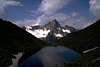
Overview
The 11th highest mountain in the Stubai mountain range. A significant mountain which can be seen from all over the surrounding area. It is a mountain with no easy ascent, the easiest one (normal route) is UIAA grade III. All ascents are partly glacial routes. Though it is possibly the mountain with the most difficult normal route in the vicinity, it is - as given in the "Alpenvereinsführer" - frequently visited.
 |  |  |  |  |
Getting There
The mountain is usually approached from either the Amberger Hütte or the Hochstubaihütte (both from the Ötztal). A further ascent starts at the Stubai cable car.
Via the Amberger Hütte:
Start in the Sulztal (goes from the Ötztal) to the Amberger Hütte (2 h). From there towards the Sulztalferner and the Wilde-Leck-Ferner to the red marked climbing route.
Via the Hochstubai Hütte:
Start in Sölden to the Hochstubai Hütte (6 h). From there to the Wütenkarsattel, down the Sulztalferner and into the Wilde Leck Ferner to the red marked climbing route.
The normal route (UIAA grade III) is red marked (1.5 h) and goes along the east ridge. No bolts are in the route.
Further routes are the direct east ridge (III-IV) the westridge (III) and the north ridge (III).
Descent is possible through the south wall (I).
When To Climb
Summer: June - October
Winter: March - April (Ski ascent - please note: skis can be used only for the approach - climbing is essential; I do *not* know whether climbing is possible in winter or spring )
Guides and Maps
The recommended guide is the "Alpenvereinsführer" "Stubaier Alpen" by Walter Klier (Bergverlag Rother, 2002)
ISBN: 3-7633-1271-4 (Description)
A detailed map is available from the Alpenverein (Stubaier Alpen - Hochstubai - 31/1 1: 25000)
This map is available with or without routes for ski mountaineering (Description).
A good map is sold by freytag & berndt (Innsbruck, Stubai - Seelrain, Brenner 1:50000, WK241).
(Description)
A guide describing the climbing routes is written by Andreas Orgler: STUBAIER ALPEN - Fels & Eis
Mountain Conditions
Mountain conditions are available from the huts in the vicinity.
Winter climbing: Propability of avalanges can been found here: Lawinenwarndienst - Österreich
Information of alpine weather is found here: Wetter
Huts in the Vicinity
General Information on huts is given in Jo's Hüttenliste
Amberger Hütte: 2135 m, Tel.: +(A) 05253 / 5605 (open end of Feb. - 15. May and beginn of July - 15. Sept.)
They have a homepage: Amberger Hütte
Hochstubaihütte: 3173 m, Tel.: +(A) 05254 / 3240 and 0664 / 3587637 (1. July - 15. Sept.)
They have a homepage: Hochstubaihütte
Red Tape
No fees, no closures.
Camping
The whole area is a "Naturschutzgebiet " (similar to a national park) which prohibits camping, possibly bivouaking is allowed (at least tolerated). Sleeping is of course possible in the surrounding huts.
Camping is possible in Volderau (some kilometers from Neustift in the Stubaital)and in the Ötztal in Längenfeld (30 km from Vent) (Homepage)
Further camping sites might be in Sölden (15 km from Vent) and Huben (20 km from Vent) in the Ötztal.
First Ascent - Historical Facts
First ascent by Zachäus Grüner from Sölden about 1865. First touristic approach by F. Drasch, L. Purtscheller and Qu. Gritsch at 1. Sept. 1877 from SO.
External Links
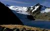
- Picture of the Wilde Leck
The Wilde Leck from east. Left-hand is the Wilde Leck Ferner (from where the normal route starts). In the front the east-ridge.
- East ridge - tour description in a weird language
A topo and a picture of the east ridge is given. I do not know which language this is.
- Austrian Map online
Online digital maps of Austria (OEK 50, OEK 200 and OEK 500) by the BEV (Bundesamt für Eich- und Vermessungswesen) - in German
JoPo - Jan 14, 2003 5:26 am - Hasn't voted
Untitled CommentTnak you for the additional information.
JoPo
Mathias Zehring - Jan 11, 2003 1:01 am - Voted 10/10
Untitled CommentHi JoPo,
I have only some small additions to make:
- the Stubai Alps are no National Park (like Yellowstone, Hohe Tauern etc)
- Wilde Leck has probably the most difficult normal route of the mountains of the area. Is it really "frequently visited"?
- Link to the map 1:25000 AV-Karte Hochstubai is http://www.dav-lifealpin.de/ProductDetail.asp?ProductID=13801&NextPage=%2FProductTree%2Easp%3FCategoryID%3D3923%26PPP%3D%26SP%3D0
- ski can only be used for the approach. This can only make sense in late spring if the rocks are free of snow
- you should tell what gear is necessary. Are there bolts? An extra route would be nice.
Mathias
JoPo - Jan 14, 2003 5:26 am - Hasn't voted
Untitled CommentTnak you for the additional information.
JoPo