
|
|
Mountain/Rock |
|---|---|
|
|
42.90700°N / 19.40700°E |
|
|
Mountaineering |
|
|
7470 ft / 2277 m |
|
|
Overview
 Impressive Babji Zub peak
SINJAJEVINA range belong to the group of most impressive mountain ranges of Montenegro and also of Dinaric Alps. That's a huge massif which streches between DURMITOR on the NW, BJELASICA on the SE, MORACKE PLANINE on the SW and VOJNIK on the E.
The highest peak of Sinjajevina is Babji Zub (2277 m)(Torna) which is located on the S part of Sinjajevina massif. Babji Zub is beautiful peak, its impressive eastern wall is placed above green paradise of Gornje Lipovo village and its surroundings. On the other, western side, Babji Zub and its rocky slopes dominate above green Dragovica Polje valley, Moracke Planine range and impressive Moraca Canyon, which is located between Sinjajevina and Moracke Planine.
 Panorama of Babji Zub
 NE side of Babji Zub
Babji Zub is placed between Gradiste (2174 m) on the N, Stolovi (2172 m) on the NE, Jablanov Vrh (2203 m) on the E and Moracke Planine range on the W-SW. From Gradiste, Babji Zub is separate by beautiful grassy pass which is amazing viewpoint to three sides - to the whole range of Moracke Planine (2226 m) on the W, to Gradiste and Stolovi group on the N-NE and to Jablanov Vrh on the E. Of course, we can't forget the northern side of Babji Zub.
Babji Zub is peak which offer an unforgetable experiencies, lot of enjoyment and fulfilment of soul. Its beautiful summit ridge is exposed on some places, so the use of hands is necessary. Classical climbing route starts from Gornje Lipovo village and continue accross wonderful grassy pass Djedov Do (1943 m) which is placed on the N side of Babji Zub. After that the path leads on the eastern rocky slopes of Babji Zub from where you can reach the summit ridge and finally the summit of Babji Zub.
Summit View
 On the ridge of Babji Zub
 Gradiste and Stolovi
The summit of Babji Zub (2277 m) offer many impressive views and panoramas.
NW: DURMITOR (Bobotov Kuk 2523 m, Bezimeni Vrh 2487 m), Prutas 2393 m)
SE: MORACKE PLANINE (Kapa Moracka 2226 m, Tali, Stozac 2141 m,...), MAGANIK (Medjedji Vrh 2138 m,...)
E: BJELASICA (Crna Glava 2139 m, Zekova Glava 2122 m,...)
NE: Gradiste (2174 m), Stolovi (2172 m)
NE: Jablanov Vrh (2203 m)
Routes Overview
 Going to Babji Zub
 Babji Zub from Gradiste
BABJI ZUB (TORNA, 2277 m)
Coordinates: 42°51'47.5'' N ; 19°23'01.0'' E
Route: Kolasin town (940 m) - Gornje Lipovo - Klisura (1189 m)(T2) 1h - Katunina (1418 m)(T3) 1.30h - Djedov Do - Dzavrlje - Babji Zub (Torna, 2277 m)(T3+T4) 2.30h: 5h
Height difference: 1088 m
Lenght: 7.5 km
Duration: 5h
Trail: Partial marked
Registration book with stamp on Babji Zub (2277 m) summit
ACCESS: Gornje Lipovo and the settlement of Klisura (1189 m) is where the trails begins. The marked path goes above the locales of Katunina, steeply ascends through the forest, to 1600 m. It then goes above the forest and beside the rock through called Popov Do, then breaks through the Djedov Do valley Pass (1943 m). From this pass the view opens to Moracke Planine and Mt Maganik (2139 m). From there turn east, and then a slight descent northward along shortcuts through the rocky slopes of Torna and the former katun of Djedov Do. Continue to the end of this amphitheatre to Dzavrlje, a classic glacial trough. From this point there is a marked path leading west to the upper ridge Mt Torna. The ascent crosses steep grassy steppes, made up of loose stones that easily slide and represent a potential danger. On the highest peak of Torna - Babji Zub (2277 m), there is an official register book. The view from the summit includes the Plasnica Valley, the hamlet of Lipovo and towards the south, the Moracke Planine (Moraca Mountains, 2226 m).
As an alternative, the return from Babji Zub can be made by steep descent on a former livestock trail through the village of Redice, then to the settlement of Polje Dragovica (T3, 4h). Farther on, there is an asphalt road 14 km long to the settlement of Mioska on the Kolasin-Podgorica road.
 Djedov Do (1943 m) pass
Getting There
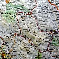 Sinjajevina Map
By plane:
The closest airport is the one in Podgorica (70km away).
If you are planning to come via Serbia, you can use the Belgrade (Beograd) Airport in Beograd (Belgrade) city, capital of Serbia and Montenegro.
Information about flights and tickets on JAT Airways web page.
By train:
Beograd - Bar (Bar - Beograd) railway passes through Mojkovac and Kolasin. In winter, there is a special ski-train for Kolasin from Bar and Podgorica. When you get off it, a ski bus will take you straight to the ski resort. After coming to Kolasin town, turn back by road (Kolasin-Mojkovac direction) and than go left (before "Djevojacki Most" restaurant) to Gornje Lipovo village.
By Bus:
From Beograd (Belgrade):
Beograd (Belgrade) - Cacak - Uzice - Zlatibor - Nova Varos - Prijepolje - Bijelo Polje - Mojkovac - Gornje Lipovo village
From Podgorica:
Podgorica - Kolasin - Gornje Lipovo village
For the bus tickets and informations about but lines see Belgrade Bus Station page.
By car:
From Beograd (Belgrade):
Beograd (Belgrade) - Cacak - Uzice - Zlatibor - Nova Varos - Prijepolje - Bijelo Polje - Mojkovac - Gornje Lipovo village
Crossroad (on Kolasin-Mojkovac road) - Gornje Lipovo village: 12 km (asphalt road)
From Podgorica:
Podgorica - Kolasin - Gornje Lipovo village
You should drive along the central Montenegrin highway, which connects the seaside to the towns: Cetinje - Podgorica - Kolasin - Mojkovac - Bijelo Polje; and goes to Serbia (Belgrade city). This road is passable during most part of the year. It is closed only in case of abundant snowing or great rockslides. The landscape along the highway is particularly picturesque in the segment of the Moraca River Canyon between Podgorica and Kolasin. This part of the canyon is called "Platije". The highway is built along the edge of the narrow canyon.
From Podgorica you can also take the village road for Kolasin. It goes across Lijeva Rijeka, Verusa and Matesevo. One part of it goes along the Tara River, which in this area is like a small, gentle and playful spring. The road is narrow, but in good condition. From the north, you will reach Kolašin if you take the highway that passes through Mojkovac. If you are coming from the east you should go across Andrijevica through Matesevo to arrive to Kolasin.
Camping
 Camping in Gornje Lipovo village
Optimal camping place for climbing of Babji Zub is Gornje Lipovo village. Here you can camping for free, without any payment of camping taxes. Near grassy meadow for camping you'll find one house where you can use water spring.