
-
 10613 Hits
-
 90.48% Score
-
 32 Votes
|
|
Mountain/Rock |
|---|---|
|
|
34.94674°N / 101.6852°W |
|
|
Randall |
|
|
Hiking, Scrambling |
|
|
Spring, Summer, Fall, Winter |
|
|
3245 ft / 989 m |
|
|
Overview
 The Sunday Flats seen from the summit of Capitol Mesa
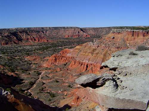
The Palo Duro Canyon is one of Texas’ greatest natural wonders. Slicing through the unrelenting flatness of the Llano Estacado for over fifty miles, the canyon provides a dramatic contrast to the vast plains that surround it. Often referred to as the Grand Canyon of Texas, the Palo Duro is a canyon of surprising magnitude. Like the Grand Canyon, it is a region unto itself, with countless subordinate canyons and draws, peaks, mesas and expansive badlands formations. Capitol Mesa is one of the best examples of the terrain one can expect to find in the canyon, many of the finest attributes of the Palo Duro being represented in abundance along the rim of the mesa. Brilliantly colored badlands formations line Capitol Mesa’s flanks, rocky pinnacles jut suddenly from its slopes and stark white caprock boulders rest at unusual angles as if washed off the rim by some great flood. Hoodoos, so commonly associated with Bryce Canyon and other areas in the southwest, make a dramatic appearance on Capitol Mesa. In addition to the small formations on the mesa itself, the nearby Lighthouse is one of the most spectacular hoodoos anywhere.
The Palo Duro Canyon is a fairly narrow affair for its first twenty miles, from the town of Canyon, Texas, to the northern boundary of Palo Duro Canyon State Park. Once it enters the park, it begins to widen considerably. The central portion of the park is generally low and flat, surrounded by cliffs exceeding 800 feet in height. Into this flat area extends Capitol Mesa, providing fairly dramatic relief. The mesa begins on the southern rim of the canyon and extends north along a narrow spine. At the mesa’s terminus is Capitol Peak, so named presumably because of the peaks’ resemblance to the capitol dome (in Austin rather than Washington D.C. no doubt). Capitol Peak is one of the more dramatic summits in the Palo Duro Canyon because of its steep walls and conical shape. However, climbing it is strongly discouraged since no route to the top exists that would not disturb the fragile, colorful badlands formations. In many ways, the mesa is a much more satisfying climb, since one retains views of Capitol Peak.
 A caprock pinnacle on the flank of Capitol Mesa
Capitol Mesa is classic Llano Estacado terrain. The lower flanks are bright red and gold badlands. The higher areas consist of thick sandstone and caliche (a form of calcium carbonate). This is the caprock from which the region, the Caprock Canyonlands, gets its name. To the north and west of the mesa is the drainages of Sunday and Little Sunday Creeks, which join the Prairie Dog Town Fork of the Red River just north of Capitol Peak. East of the mesa is Capitol Peak Canyon. The mesa generally rises 200 to 300 feet above the surrounding canyon floor.
Perhaps the primary attraction of Capitol Mesa is the views it provides and the opportunity for easy off-trail hiking to the Lighthouse. The typical trail to the great hoodoo is possibly the busiest hiking trail in west Texas. By hiking Capitol Mesa, one is absolutely guaranteed solitude en route to the lighthouse. In addition, the views from the top of the mesa are far better than any of those along to the Lighthouse Trail. If so desired, an excellent loop can be assembled by hiking the length of Capitol Mesa to the Lighthouse and then returning to the park road via the Lighthouse Trail.
Route
A detailed description of the route to Capitol Mesa can be found here.Capitol Mesa Map
 Capitol Mesa Area
Getting There
From Amarillo, drive south on I-27 for 17 miles. Drive east on Highway 217 for 11 miles to the entrance of Palo Duro Canyon State Park. Continue on the park road, making a steep descent into the canyon. Once on the canyon floor, follow the road south, making two crossings of the Prairie Dog Town Fork of the Red River. Immediately following the second crossing, park in the signed parking lot for the Lighthouse Trail.Red Tape
 Looking east toward the Fortress Cliffs from the ravine accessing the top of Capitol Mesa
A $5.00 entrance fee is charged per person.
Most Texas state parks are generally not noted for the wilderness characteristics. Despite the numerous campgrounds, picnic sites, amphitheatres and such, most of Palo Duro Canyon State Park is de facto wilderness. Consequently, normal wilderness rules and ethics should be followed. In particular, pay special attention to the fragile clay formations on the colorful badlands that form the lower flanks of Capitol Mesa. Once these have been trod upon, it will take many years for the tracks to be washed away.
Palo Duro Canyon State Park
11450 Park Road 5
Canyon, TX 79015
(806) 488-2227
Camping
 Little Sunday Creek and Capitol Mesa from near the Lighthouse
Palo Duro Canyon State Park has an overabundance of camping facilities. In addition to equestrian campsites and three large RV campgrounds, the two developed primitive campgrounds “Fortress Cliff” and “Cactus” are available. These are the most desirable in terms of ambience, price and slightly more “wild” feeling. Dispersed camping is allowed south of the park road turnaround, provided one packs in at least 30 minutes before setting up camp.
When To Go
Capitol Mesa can be climbed any time of year. Summer can be brutally hot, so it would be best to hike it early in the morning.External Links
Palo Duro Canyon State ParkPalo Duro Canyon